Our 3D Scanning Process: Precision in Every Detail
In the modern world of architecture, construction, and engineering, precision is everything. Whether you’re restoring a historical monument or planning a new build, accuracy in measurement and design is essential. 3D laser scanning services deliver a level of precision and detail far beyond what traditional methods can achieve. At our company, we specialize in delivering as-built documentation using 3D laser surveys that produce point clouds, 3D models, and 2D drawings. Our build information modeling (BIM) solutions offer clients the most accurate visual representation of their projects.
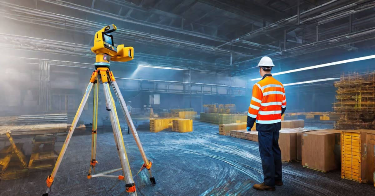
Our 3D scanning services follow a comprehensive, structured process that ensures you receive the most accurate and actionable data. With the use of high-end equipment such as Leica, FARO, and Trimble X7 scanners, we can scan a wide range of objects—from historical buildings to complex industrial machinery. This enables us to deliver precision solutions to architects, builders, and designers across the United States. Let’s take a closer look at our scanning process.
Before starting any project, we collaborate closely with our clients to gain a thorough understanding of their specific requirements. If the client does not provide a detailed technical assignment, our team will assist in drafting one. This crucial step allows us to customize our approach for every 3D laser survey, whether you’re looking for 3D models for Scan to BIM or detailed as-built documentation. We take time to align on every detail, ensuring that the results meet your project’s specific requirements.
Once the project scope is clearly defined, our team schedules a time to visit the site for scanning. We understand that flexibility is key, so we coordinate with you to select a time that minimizes disruption to your business or ongoing construction. Whether you’re located in New York City, Los Angeles, or a smaller town, our team will be on-site and ready to perform 3D scanning services with meticulous attention to detail.
The scanning itself is where cutting-edge technology meets skilled execution. Using laser scanners from Leica, FARO, and Trimble X7, we perform high-precision 3D laser surveys of any structure or object. The scanning process involves the following key steps:
This scanning process can be completed within a few hours or, for larger projects, over several days. Despite the complexity of the project, we ensure minimal disruption to ongoing operations on the site.
After the on-site scanning is complete, the data undergoes detailed post-processing. This phase is where raw scan data is transformed into useful deliverables for your project. Using specialized software, we clean, refine, and optimize the point cloud to remove noise and ensure the highest quality. From here, we produce a range of outputs, depending on your needs:
No matter the final output, all data is checked for accuracy before delivery. We guarantee that every measurement, drawing, and model is precisely aligned with your project’s unique specifications.
Our goal is to deliver results that are both accurate and usable. Depending on the project size, you can expect to receive your final results within as little as two days for smaller projects, or up to two months for large, complex sites. Regardless of timeline, you will receive your 3D models, 2D drawings, or point clouds in your preferred format, whether that’s .DWG, .PDF, .JPEG, or another compatible file type.
What makes us stand out in the 3D scanning services market is not just the cutting-edge technology we use but the meticulous care and precision we bring to every project. Here’s why clients across the U.S. choose us for their laser surveys and as-built documentation:
With scanning technology that achieves accuracy down to 1 millimeter, we guarantee highly detailed and reliable data for every project. Whether it’s a complex 3D laser survey of an industrial plant or capturing the intricacies of a historic building, our results are second to none.
Our team is capable of reaching any site in the United States, from bustling metropolitan areas to remote locations. No matter where your project is based, we take pride in delivering the same exceptional level of service across the board. From scanning sports facilities in Texas to surveying historical landmarks in Washington D.C., our process remains seamless and efficient.
We believe in making cutting-edge technology accessible. One of our primary advantages is our ability to offer 3D scanning services at competitive prices, especially for projects that require 2D drawings or simple as-built documentation. Our clients enjoy top-tier results at a price significantly below the market average.
Our commitment to quality is uncompromising. Each data deliverable undergoes thorough scrutiny and review to ensure it upholds our strict quality standards. We focus on accuracy, completeness, and delivering results without errors or omissions. Our unwavering commitment to quality is the reason clients trust us with their most critical projects.
Our 3D scanning services can be applied across numerous industries, providing accurate data for a variety of uses. Whether you’re an architect, engineer, or project manager, the information we provide can assist in:
With our expertise, the possibilities are limitless, ensuring you receive the most precise results for your project.
Our 3D laser scanning technology provides measurements accurate to within 1 millimeter, ensuring highly detailed and precise data.
We deliver results in multiple formats, including .RVT, .DWG, .PDF, .3DS, and .JPEG, among others.
Yes, we specialize in scanning both small and large-scale projects, including bridges, highways, and other extensive infrastructure systems.
For smaller projects, we can deliver results in as little as two days. Larger, more complex projects may take up to two months.
Yes, we operate throughout the United States and can provide 3D laser scanning services in any location, whether urban or rural.
We cater to a wide range of industries, from architecture and construction to engineering, infrastructure development, and historic preservation.
In conclusion, our 3D laser scanning process is designed to provide fast, accurate, and affordable solutions for projects of any scale. From generating 3D models to creating as-built documentation, we ensure every client receives results that exceed their expectations. Our team is ready to take on projects anywhere in the United States, delivering precision data that drives success.