Welcome to SCANM2.COM – Your Premier Destination for 3D Point Cloud Laser Scanning Services
Embark on your projects with confidence, backed by the precision of our As-Built Surveys. We provide various services at SCANM2.COM. These include 3D Laser Scanning, 3D Point Cloud Stitching, 3D Modeling, BIM Models, and 2D CAD Documentation. Our services cater to engineering, technology, architecture, design, and landscaping projects.
Elevate Your Projects with As-Built Surveys
Every successful project begins with a solid foundation – an As-Built Survey, also known as an Existing Conditions Survey. This survey serves as the bedrock upon which your vision takes shape. Our surveys capture intricate details and accurate measurements of decorative features and engineering networks. We design our cutting-edge 3D point cloud laser scanners to precisely capture the intricacies of your project.
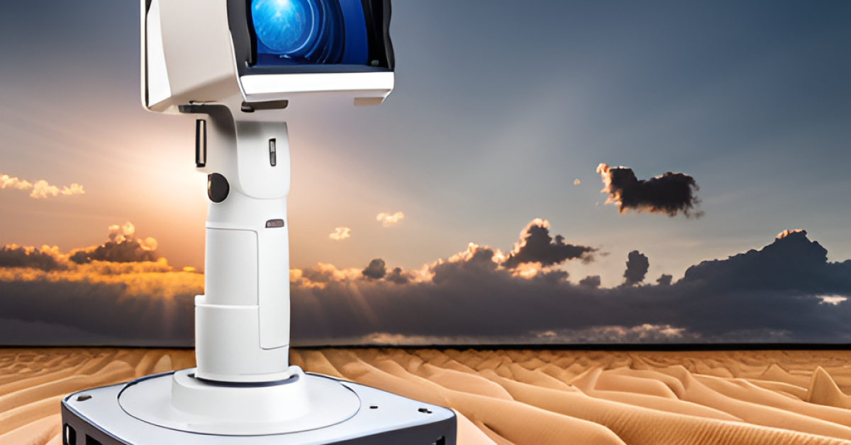
Precision Beyond Compare
Our cutting-edge 3D Laser Scanning Technology (TLS) ensures unparalleled precision, performing a staggering 1 million measurements per second. Compared to traditional methods, this is a staggering 100-fold increase in efficiency. With a margin of error as low as 1-2 mm, you can trust in the accuracy of every data point.
Our team designs our 3D laser scanners for the real world, ensuring they produce high-quality data for your projects. These scanners produce data that forms the foundation of your project’s success.
Unmatched Expertise in 3D Point Cloud Processing
Post-scan, we meticulously process and clean the 3D point cloud data, ensuring clarity and accuracy in every detail. Skilled engineers in our design department receive the data and create 2D and 3D documentation and models.
Seamless Integration with Your Preferred Software
Our engineers are skilled in using a variety of standard industry software such as Archicad, AutoCAD, Revit, Sketchup, among others. This ensures seamless integration with your existing workflow, maximizing efficiency and minimizing disruptions. We’re experts in building information modeling, allowing you to work with the file formats that best suit your needs.
Short Turnaround Times, Global Excellence
Backed by advanced technology and years of expertise, we proudly complete an impressive 3.5 projects every day across the globe. From Poland and Germany to France, the UAE, and the USA, our commitment to excellence knows no bounds. Our terrestrial laser scanner technology enables efficient reality capture for your projects.
Scan to BIM – Where Precision Meets Efficiency
Experience the transformative power of Scan to BIM with SCANM2.COM. We are experts in laser scanning. We provide precise 3D measurements in point cloud format to enhance your projects with accurate data.
Trusted by Industry Leaders
We help various businesses and individuals with their surveying needs, including project companies, design studios, engineering firms, and private investors. After all, as the old adage goes, “Measure seven times, cut once.”
Elevate Your Projects Today
Unlock the full potential of your projects with SCANM2.COM. Contact us today and experience the difference precision makes in scanning processing and data quality.
FAQs
What is 3D Laser Scanning?
3D Laser Scanning is a technology that uses laser beams to capture the precise shape and dimensions of objects and environments. It rapidly measures and records millions of data points to create a detailed 3D representation, known as a point cloud.
What is an As-Built Survey and why is it important?
An As-Built Survey, also known as an Existing Conditions Survey, provides accurate measurements and details of existing structures or environments. It serves as the foundation for planning and designing projects, ensuring that new elements integrate seamlessly with the existing surroundings.
How precise are your 3D Laser Scanning measurements?
Our 3D Laser Scanning Technology performs a million measurements per second, with a margin of error as low as 1-2 mm. This level of precision ensures that you can trust the accuracy of every data point.
What services do you offer at SCANM2.COM?
We provide a range of services including 3D Laser Scanning, 3D Point Cloud Stitching, 3D Modeling, BIM Models, and 2D CAD Documentation. These services cater to engineering, technology, architecture, design, and landscaping projects.
How do you process and clean the 3D point cloud data?
After scanning, our skilled engineers meticulously process and clean the data to ensure clarity and accuracy in every detail. This involves refining the point cloud to remove any noise or inaccuracies.
Can I use my preferred software with the data provided?
Yes, our engineers are proficient in using standard industry software like Archicad, AutoCAD, Revit, Sketchup, and more. This ensures seamless integration with your existing workflow, maximizing efficiency.
How long does it take to complete a project with SCANM2.COM?
Backed by advanced technology and years of expertise, we complete an impressive 3.5 projects every day globally. Turnaround times may vary depending on the scope and complexity of the project.
What regions do you serve?
We proudly serve clients globally, including regions like Poland, Germany, France, the UAE, and the USA. Our commitment to excellence knows no geographical bounds.
What industries and clients do you work with?
We work with a diverse range of clients, including project companies, design studios, engineering firms, and private investors. Our services cater to a wide array of industries that require precise surveying and measurement solutions.
How can I get started with SCANM2.COM?
To get started, simply contact us through our website or reach out to our dedicated team. We’ll be happy to discuss your project requirements and provide you with the precision and expertise that SCANM2.COM is known for.