Laser Scanning Topographic Survey for Landscape Design in Abu Dhabi
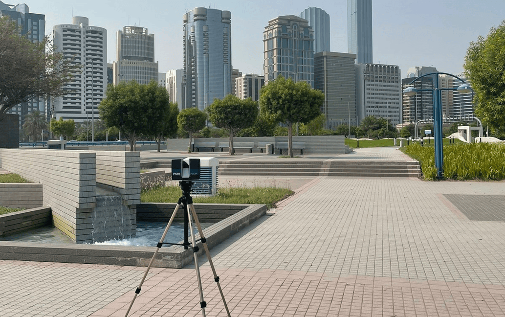
At ScanM2, we pride ourselves on providing 3D laser scanning and modeling services with the highest precision, tailored for clients working in landscape design and architectural fields. Recently, our team completed a project at Corniche Seaside Park, located in Abu Dhabi, using cutting-edge laser scanning technology to deliver precise 2D drawings and BIM-ready 3D models.
Through this project, we helped a landscape design firm gather accurate topographic data with an unprecedented precision of 2 millimeters, surpassing standard LIDAR methods and empowering them to create detailed, functional designs.
Corniche Seaside Park Laser Scanning for Accurate Landscape Design
- Industry: Landscape Design
- Location: Abu Dhabi, UAE
- Year of Completion: 2024
- Total Area Scanned: 700 square feet

For this project, our goal was to provide detailed laser scanning topographic surveys to assist the design firm in creating an accurate landscape plan for Corniche Seaside Park. Using the most advanced 3D scanning technology, we provided our client with critical topographical data, ensuring that all terrain features were captured with high precision.
3D Laser Scanning for Topographic Surveys: Delivering Precision and BIM Models
For the Corniche Seaside Park project, we deployed state-of-the-art Faro, Leica, and Trimble stationary laser scanners, ensuring that every detail of the park’s topography was recorded with maximum accuracy. The primary objectives were to:
- Capture precise topographical data for landscape design purposes.
- Convert this data into accurate 2D drawings and a detailed 3D model that could easily integrate with BIM (Building Information Modeling) workflows.
- Provide documentation that exceeded the client’s expectations in terms of accuracy, quality, and cost-efficiency.
2D Drawings and 3D BIM Models for Enhanced Design Workflows
Upon completing the laser scanning process, we delivered the following results to the client:
- Detailed 3D Laser Scanning: Our 3D scanning captured the park’s terrain with an unmatched precision of 2 millimeters. This level of detail enabled the client to design more effectively, using exact data for each landscape element.
- 2D Drawings for Architectural Documentation: From the scanned data, we created 2D drawings, which were essential for understanding the elevation changes and features of the park’s landscape. These As-Built drawings deliverables were indispensable for the designers.
- 3D BIM Models: Using the point clouds generated from the laser scanning, we constructed a 3D model ready for BIM integration. This model gave the landscape designers a clear and comprehensive visualization of the park’s current conditions, facilitating seamless design planning and future project phases.
Advantages of 3D Laser Scanning Over LIDAR for Land Surveying and BIM
3D laser scanning offers significant advantages over traditional LIDAR systems, particularly when it comes to projects like Corniche Seaside Park, which require high levels of precision. Here’s why ScanM2’s laser scanning services stand out:
- Unmatched Precision: Our laser scanners offer 2-millimeter accuracy, which is far superior to the capabilities of LIDAR technology. This level of precision ensures that every topographical feature is captured in detail, critical for successful landscape design.
- Cost-Efficient: Despite offering such high-quality services, our pricing remains competitive. Our clients benefit from precision data without the hefty costs associated with traditional land surveying methods.
- Versatile Deliverables: We provide both 2D drawings and 3D models, which can be directly integrated into BIM systems. This makes it easier for clients to transition from planning to implementation.
- BIM Models and Point Clouds: Our point clouds and BIM-ready models give clients a detailed, up-to-date digital representation of their project areas, perfect for As-Built Survey and future planning.
3D Scanning in Abu Dhabi: Process & Results


Why Choose ScanM2 for 3D Laser Scanning and BIM Modeling?
Choosing ScanM2 for your 3D scanning and BIM needs means benefiting from technology that allows for unprecedented accuracy, cost savings, and adaptability. We provide:
- 2D Architectural Drawings: Essential for accurate planning and landscape design.
- 3D Models: Ready for BIM integration, these models offer the highest level of detail available.
- Point Cloud Data: Our point cloud technology ensures that every element of your project is captured, with the flexibility to update and refine as needed.
3D Scanning: The Future of Landscape Design
As the industry moves towards digital design and BIM integration, 3D laser scanning has become an essential tool for landscape designers, architects, and engineers. Some of the major benefits include:
- Improved Planning: The precise data obtained from laser scanning topographic surveys allows for more informed decision-making and reduces the risk of errors during the design phase.
- Enhanced Visualization: 3D models created from the scanned data provide clear, detailed visualizations, helping clients to see the final product before construction even begins.
- Seamless Collaboration: Our BIM models enable seamless collaboration across different teams and project stages, ensuring that all parties are working from the same accurate, up-to-date information.
FAQs
What is 3D laser scanning and how does it differ from LIDAR?
What is the advantage of using 3D scanning for landscape design?
How does BIM integration improve the design process?
What is As-Built Survey and how does it help?
How accurate is laser scanning for land surveying?
What are point clouds, and why are they important?
Contact Us
If you need high-precision 3D laser scanning for your next landscape design or architectural project, ScanM2 has the expertise and technology to deliver outstanding results. Get in touch with us today to discuss how we can support your vision with our advanced laser scanning and BIM modeling services.