LiDAR in Civil Engineering: Applications and Advantages

In the evolving world of civil engineering, precision and efficiency are paramount. Introducing LiDAR (Light Detection and Ranging), an innovative technology that has revolutionized the way engineers and construction specialists tackle their projects. From topographic mapping to 3D laser scanning, LiDAR offers a suite of tools that enhance accuracy, reduce costs, and streamline workflows. This blog will delve into the applications and advantages of LiDAR in civil engineering, shedding light on why it has become a cornerstone of modern construction and design.
What is LiDAR Technology?
LiDAR operates by emitting laser pulses to accurately calculate the distance between the sensor and various objects on the ground. LiDAR generates highly detailed 3D representations of the environment by emitting thousands of laser pulses each second. These models, often referred to as point clouds, offer unparalleled accuracy and can capture intricate details of terrain, structures, and vegetation.
LiDAR sensors are typically mounted on drones, airplanes, or ground-based systems, making it a versatile tool for a variety of applications. With its ability to gather data in real time, LiDAR has revolutionized how civil engineers approach their projects, enabling data-driven decision-making at every stage of development.
Key Applications of LiDAR in Civil Engineering
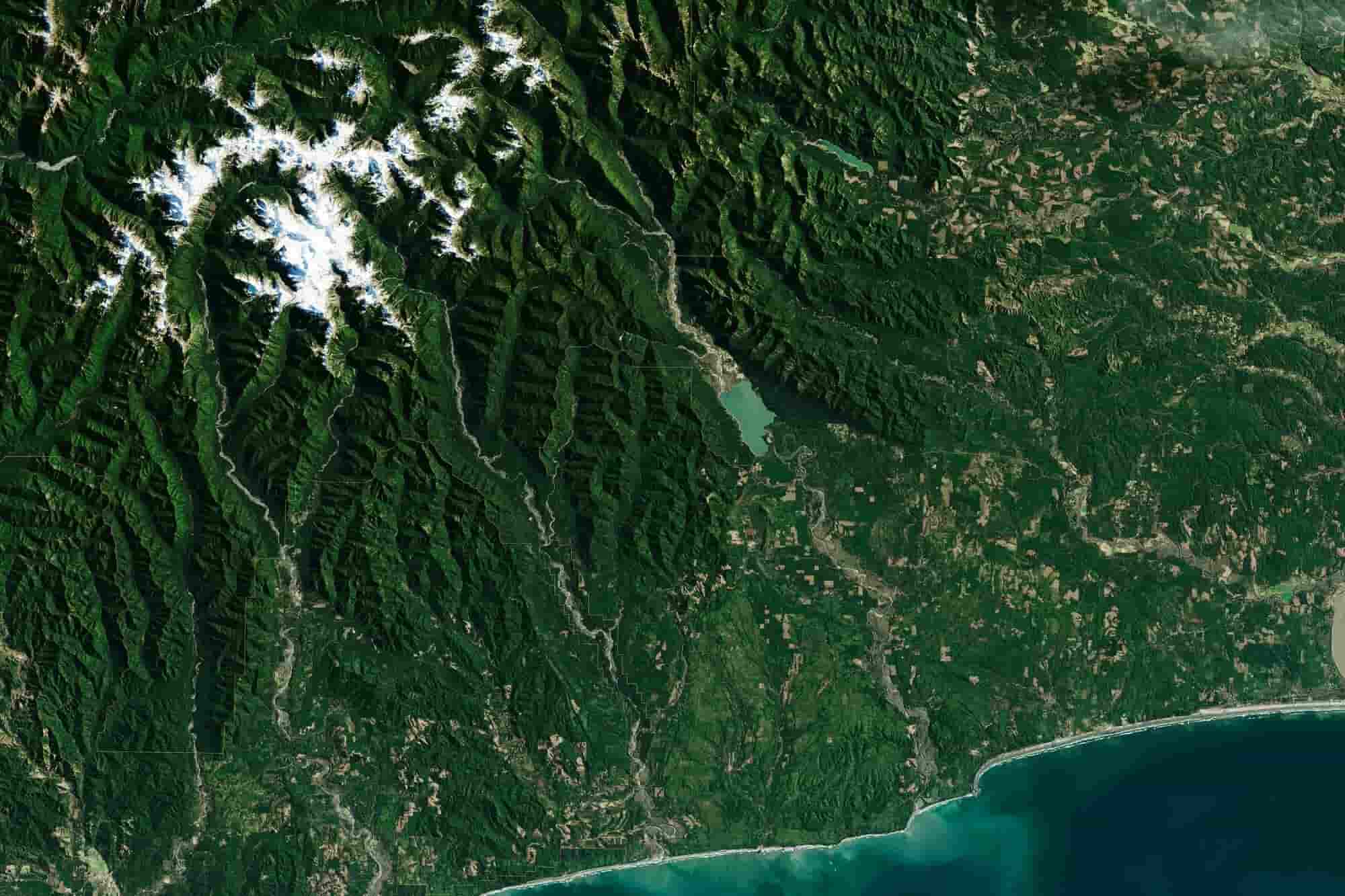
Topographic Mapping
LiDAR plays a crucial role in topographic mapping, a core application in civil engineering. Unlike traditional surveying techniques, which can be time-intensive and may fall short in accuracy for large-scale endeavors, LiDAR offers a faster and more precise alternative. LiDAR, however, generates highly accurate topographic maps in a fraction of the time.
- Site Analysis: Engineers use LiDAR-generated maps to analyze terrain before construction begins, identifying potential challenges like uneven ground or flood-prone areas.
- Urban Planning: LiDAR supports the design of infrastructure projects like roads, bridges, and buildings by delivering precise and detailed elevation data.
LiDAR in Construction
LiDAR plays a critical role in modern construction workflows, from initial site surveys to project completion.
- Volume Calculations: LiDAR helps measure the volume of excavated or filled materials, ensuring precise resource management.
- Structural Monitoring: During construction, LiDAR can monitor the progress and alignment of structures, minimizing the risk of errors and rework.
- 3D Modeling: LiDAR data is often integrated into Building Information Modeling (BIM) systems, providing accurate 3D representations of the construction site.
Flood Risk Assessment
LiDAR’s ability to capture high-resolution elevation data makes it invaluable for flood risk assessments.
- Watershed Analysis: Using topographic data from LiDAR, engineers can assess water flow patterns and pinpoint regions vulnerable to flooding.
- Drainage Design: LiDAR data enables the creation of effective drainage systems, minimizing the potential for water-related damage to infrastructure.
Highway and Road Design
LiDAR has transformed highway and road design by providing engineers with detailed data about existing roadways and their surroundings.
- Alignment and Grading: Engineers use LiDAR to design road alignments and grading plans that meet safety and regulatory standards.
- Obstacle Detection: LiDAR helps identify potential obstacles, ensuring smoother construction processes.
Environmental Impact Assessments
Environmental sustainability is a critical aspect of civil engineering. LiDAR supports this by offering detailed data that helps minimize environmental disruption.
- Vegetation Mapping: LiDAR can distinguish between different types of vegetation, aiding in conservation efforts.
- Wildlife Habitats: Engineers use LiDAR to map and protect wildlife habitats during construction.
3D Scanning in Abu Dhabi: Process & Results


Advantages of LiDAR in Civil Engineering
- Accuracy and Precision: LiDAR provides centimeter-level accuracy, which is essential for civil engineering projects. LiDAR’s capability to capture intricate details ensures that designs are grounded in accurate data, significantly minimizing the margin of error.
- Time Efficiency: Traditional surveying methods can take weeks, if not months, to complete. LiDAR drastically reduces this timeframe, enabling faster project initiation and completion.
- Cost-Effectiveness: While the initial investment in LiDAR technology may seem high, its ability to minimize errors, reduce rework, and optimize resource usage leads to significant cost savings over time.
- Versatility: From aerial surveys to ground-based scans, LiDAR adapts to various project needs. Its applications span urban planning, environmental assessments, and infrastructure design.
- Data Integration: LiDAR data integrates seamlessly with modern design tools like BIM and CAD, enabling engineers to create comprehensive 3D models and simulations.
The Future of LiDAR in Civil Engineering
As LiDAR technology advances, its potential applications within civil engineering are anticipated to grow even further. Improvements in sensor technology, data processing capabilities, and machine learning integration will make LiDAR more powerful and accessible than ever before.
A growing trend is the integration of LiDAR with artificial intelligence (AI), enabling advanced predictive modeling capabilities. By analyzing LiDAR data, AI can identify patterns and provide insights that help engineers make proactive decisions. Moreover, the increasing use of drones equipped with LiDAR sensors is revolutionizing large-scale projects by providing cost-effective and highly efficient solutions.
Conclusion
LiDAR technology has established itself as an essential tool in civil engineering, delivering unmatched accuracy, efficiency, and adaptability. From topographic mapping to environmental assessments, its applications are reshaping the industry and setting new standards for precision and sustainability. As the technology continues to advance, LiDAR’s role in civil engineering will only grow, driving innovation and excellence in construction and design.
For professionals looking to elevate their projects, integrating LiDAR into their workflows is no longer a luxury but a necessity. ScanM2.com offers cutting-edge LiDAR solutions tailored to the needs of civil engineers, ensuring that every project is built on a foundation of accuracy and reliability.