In the world of modern construction and design, precision is key. Every project, whether in engineering, technology, architecture, design, or landscaping, starts with an essential step: the As-Built Survey, also known as an Existing Conditions Survey. This survey, utilizing innovative technologies like point cloud laser scanning, point cloud laser scanner, and 3D laser scanning, forms the foundation of future projects. Our business, SCANM2.COM, is your partner in delivering precision and efficiency. Contact us today to transform your projects with point cloud laser scanning.
Understanding Point Clouds Laser Scanning
What is Point Cloud Data?
Point Cloud Data is a digital representation of a physical space or object. It is a collection of millions of data points in a three-dimensional coordinate system. These points are generated using a 3D laser scanner, capturing the exact spatial position of objects within the surveyed area. This data forms the basis for creating accurate 2D and 3D models of existing structures.
Principles of Laser Scanning Technology
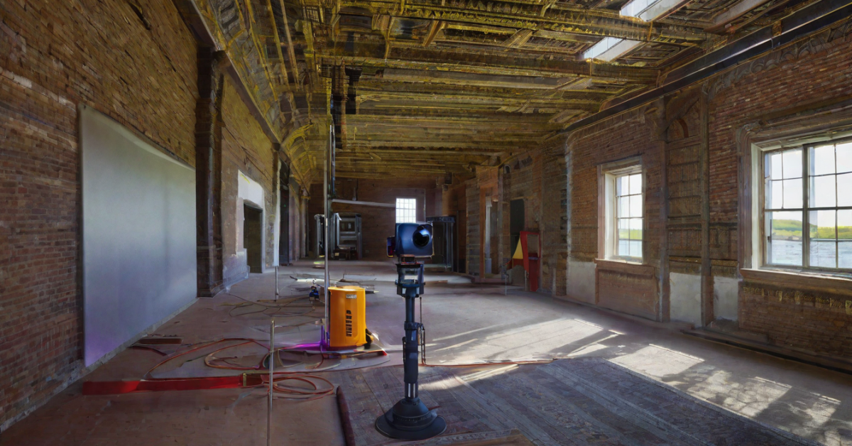
Laser Scanning Technology, specifically Terrestrial Laser Scanning (TLS), is a revolutionary method of data acquisition. It utilizes a laser rangefinder to rapidly measure distances to objects, creating a dense cloud of points. This technology is capable of performing an astounding number of scans per second, making traditional methods seem glacial in comparison. The precision achieved is within an impressive range of 1-2 mm, virtually eliminating the possibility of error.
Applications of Point Clouds Laser Scanning in Various Industries
Point Clouds find applications across a spectrum of industries.
- In construction, they serve as the foundation for Building Information Modeling (BIM) modelling, enabling precise planning and design.
- In the surveying industry, they provide real-time data for accurate assessments.
- On construction sites, Point Clouds offer a scanning solution that enhances efficiency and accuracy.
- In archaeology, they facilitate the documentation and preservation of historical sites.
- Other sectors such as telecommunications, solar energy, and furniture installation benefit from the accuracy provided by Point Cloud Data.
Choosing the Right Point Cloud Laser Scanner
Factors to Consider When Selecting a Laser Scanner
Selecting the right type of laser scanner is crucial for obtaining accurate and reliable Point Cloud Data. Consider factors such as scanning range, accuracy, speed, and compatibility with software platforms like Archicad, AutoCAD, Revit, Sketchup, etc. It’s also important to assess the specific needs of your projects and choose a scanner that aligns with those requirements.
Top Brands and Models for Point Cloud Laser Scanning
Several reputable brands offer high-quality laser scanners. From industry stalwarts like Leica Geosystems to cutting-edge options like Faro and Trimble, a range of models cater to different project scopes and budgets. Researching and consulting experts can help identify the best fit for your specific applications.
Performing a Point Cloud 3D Scan
Step-by-Step Guide to Conducting a 3D Scan
- Preparation: Ensure the scanning area is clear of obstructions and properly illuminated.
- Scanner Setup: Position the laser scanner at strategic vantage points for comprehensive coverage.
- Scanning Process: Initiate the scan, allowing the laser to capture raw scan data consisting of millions of data points.
- Data Registration: Combine multiple scans to create a cohesive Point Cloud Model.
- Quality Check: Verify the integrity of the Point Cloud for accuracy and completeness.
Best Practices for Obtaining High-Quality Point Cloud Data
- Maintain consistent scanner settings for uniform data density.
- Utilize targets for improved registration and alignment of scans.
- Calibrate equipment regularly to ensure accurate measurements.
- Conduct multiple scans from different angles for comprehensive coverage.
Processing and Utilizing Point Clouds
Data Processing Techniques for Point Clouds
After the scanning process, the raw data is transformed into a Point Cloud, a cloud of precise 3D coordinates. This Point Cloud requires processing and cleaning to remove any outliers or noise. Specialized software is used for this purpose, ensuring the resulting model is accurate and reliable.
Integrating Point Clouds into CAD Software and GIS Applications
Once the Point Cloud is processed, it serves as the foundation for creating 2D and 3D documentation. Skilled engineers proficient in software platforms like Archicad, AutoCAD, Revit, Sketchup, etc., use this data to generate detailed models. This integration streamlines the design process, enabling precise planning and execution.
Advantages and Limitations of Laser Scanning and Point Clouds
Benefits of Utilizing Point Cloud Data
- Unparalleled Precision: Point Cloud Data provides a level of precision that traditional surveying methods simply cannot match. With measurements accurate within 1-2 mm, it ensures a high level of fidelity in the resulting models.
- Time Efficiency: 3D laser scanning technology is incredibly efficient, performing a large number of scans per second. This expedites the data collection process, allowing for quicker project turnaround times.
- Reduced Error Margin: The possibility of error is virtually eliminated with laser scanning. This high degree of accuracy ensures that design decisions are based on reliable data.
Common Challenges and How to Overcome Them
- Data Processing Complexity: Processing large Point Clouds can be resource-intensive. Utilizing powerful computers and specialized software is crucial for efficient data processing.
- Scan Registration Issues: Ensuring that multiple scans align accurately can be challenging. Using targets and employing experienced technicians can help mitigate registration errors.
Future Trends in 3D Laser Scanning and Point Cloud Technology
Emerging Technologies in Laser Scanning
- Mobile Laser Scanning: This technology involves mounting laser scanners on vehicles, allowing for rapid data collection over large areas.
- Drone LiDAR: Drones equipped with LiDAR sensors are becoming increasingly popular for capturing data in hard-to-reach or expansive areas.
Predictions for the Evolution of Point Cloud Usage
As technology continues to advance, we can expect even more seamless integration of Point Cloud Data into various industries. Automation and artificial intelligence may play a larger role in data processing, further enhancing efficiency and accuracy.
Exploring the Power of Laser Scanning in Point Cloud 3D
Mastering Point Cloud Laser Scanning Techniques
Key Concepts in Point Cloud Data Acquisition
Understanding the fundamentals of laser scanning, including principles of operation, scanner settings, and data collection best practices, is essential for obtaining high-quality Point Cloud Data.
Leveraging Laser Scanning for Precise 3D Models
By harnessing the power of laser scanning technology, designers and engineers can create highly detailed and accurate 3D models. These models serve as the foundation for informed decision-making and seamless project execution.
The Ultimate Guide to Point Cloud Laser Scanners
In-Depth Analysis of Top Laser Scanning Devices
A comprehensive review of leading laser scanner models, highlighting their specifications, capabilities, and suitability for various applications.
Selecting the Ideal Scanner for Your Specific Needs
Guidance on how to match specific project requirements with the features offered by different laser scanner models, ensuring optimal results.
Transforming Reality into Point Clouds: A Step-by-Step Tutorial
Capturing Real-World Environments with Laser Scanning
Illustrating the step-by-step process of conducting a laser scan, from equipment setup to data capture, providing practical insights for professionals in the field.
Converting Scanned Data into Actionable Point Clouds
An in-depth tutorial on data processing techniques, including tips for cleaning, registering, and extracting valuable information from Point Cloud Data.
Navigating the World of Point Cloud 3D Scanning
Applications Across Industries: From Construction to Archaeology
Exploring real-world applications of Point Cloud Data in diverse industries, showcasing the versatility and impact of laser scanning technology.
Overcoming Challenges in Point Cloud Data Processing
Addressing common hurdles faced during data processing, and offering strategies and tools to streamline the workflow for optimal results.
For unmatched precision and efficiency in your projects, contact us at SCANM2.COM for state-of-the-art 3D Laser Scanning services using Terrestrial Laser Scanners and cutting-edge technology. Let’s transform your visions into reality with Point Cloud Laser Scanning.
FAQs:
What is Point Cloud Data?
Point Cloud Data is a digital representation of a physical space or object, created using a 3D laser scanner. It consists of millions of data points in a three-dimensional coordinate system, accurately capturing the spatial position of objects within the surveyed area. This data forms the basis for creating accurate 2D and 3D models of existing structures.
What is Laser Scanning Technology?
Laser Scanning Technology, specifically Terrestrial Laser Scanning (TLS), is a method of data acquisition that uses a laser rangefinder to rapidly measure distances to objects. It creates a dense cloud of points in a three-dimensional coordinate system. This technology is capable of performing a large number of scans per second, achieving an impressive range of precision within 1-2 mm.
What are the Applications of Point Clouds?
Point Clouds have a wide range of applications across various industries. They are used in construction for Building Information Modeling (BIM), in surveying for real-time data assessments, on construction sites for enhanced efficiency and accuracy, in archaeology for historical site documentation and preservation, and in sectors like telecommunications, solar energy, and furniture installation for improved accuracy in their respective processes.
How do I Choose the Right Point Cloud Laser Scanner?
When selecting a laser scanner, consider factors like scanning range, accuracy, speed, and compatibility with software platforms like Archicad, AutoCAD, Revit, Sketchup, etc. Assess the specific needs of your projects and choose a scanner that aligns with those requirements.
What are the Steps in Conducting a 3D Scan?
The steps in conducting a 3D scan are:
1. Preparation: Ensure the scanning area is clear of obstructions and properly illuminated.
2. Scanner Setup: Position the laser scanner at strategic vantage points for comprehensive coverage.
3. Scanning Process: Initiate the scan, allowing the laser to capture raw scan data consisting of millions of data points.
4. Data Registration: Combine multiple scans to create a cohesive Point Cloud Model.
5. Quality Check: Verify the integrity of the Point Cloud for accuracy and completeness.
What are Best Practices for Obtaining High-Quality Point Cloud Data?
To obtain high-quality Point Cloud Data, it’s important to:
• Maintain consistent scanner settings for uniform data density.
• Utilize targets for improved registration and alignment of scans.
• Calibrate equipment regularly to ensure accurate measurements.
• Conduct multiple scans from different angles for comprehensive coverage.
How is Point Cloud Data Processed and Utilized?
After the scanning process, the raw data is transformed into a Point Cloud, which is a cloud of precise 3D coordinates. This Point Cloud requires processing and cleaning to remove any outliers or noise, using specialized software. Once processed, it serves as the foundation for creating 2D and 3D documentation using software platforms like Archicad, AutoCAD, Revit, Sketchup, etc., enabling precise planning and execution.
What are the Advantages of Laser Scanning and Point Clouds?
The advantages include unparalleled precision, time efficiency due to rapid scanning, and reduced error margin, ensuring design decisions are based on reliable data.
What are Common Challenges in Laser Scanning and Point Cloud Data Processing?
Common challenges include data processing complexity, which can be resource-intensive, and scan registration issues. Strategies to mitigate these challenges include utilizing powerful computers and specialized software, as well as using targets and experienced technicians for accurate registration.
What are the Emerging Technologies in Laser Scanning?
Emerging technologies include Mobile Laser Scanning, which involves mounting laser scanners on vehicles for rapid data collection over large areas, and Drone LiDAR, where drones equipped with LiDAR sensors are used to capture data in hard-to-reach or expansive areas. These technologies are advancing the capabilities of laser scanning for various applications.