How LiDAR Drone Mapping Works?
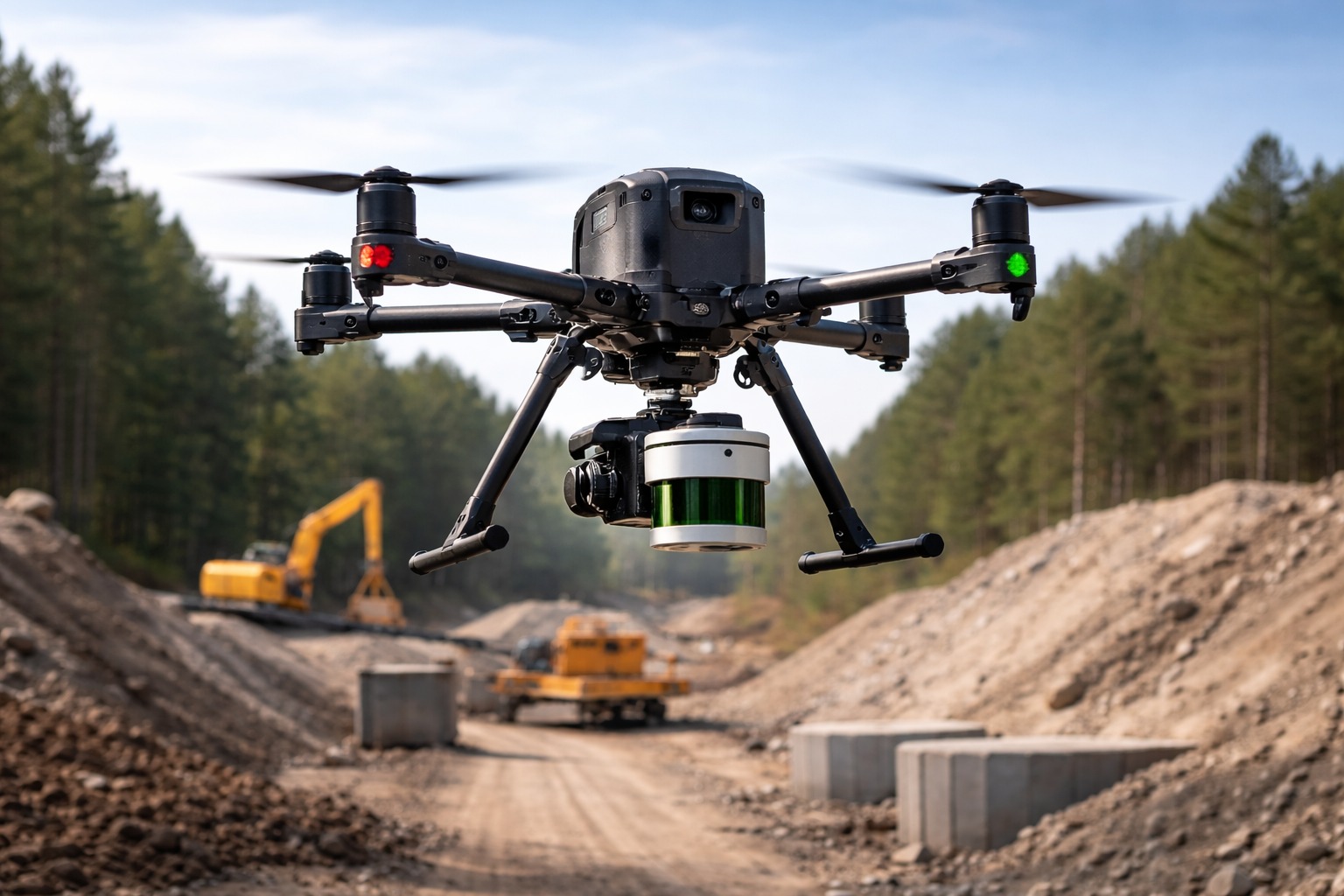

LiDAR drone mapping is a modern surveying method that uses unmanned aerial vehicles (UAVs) equipped with laser scanners to create highly accurate 3D representations of terrain and structures. By combining laser pulse measurements with advanced positioning systems, this technology delivers precise elevation models, dense point clouds, and georeferenced datasets for engineering, construction, and environmental analysis.
Unlike traditional ground-based methods, drone-based LiDAR can rapidly collect data over large and difficult-to-access areas — from forested landscapes to infrastructure corridors.
What Is LiDAR Drone Mapping?
LiDAR drone mapping refers to the process of mounting a Light Detection and Ranging (LiDAR) sensor on a UAV to measure distances using laser pulses. The system emits thousands to millions of pulses per second toward the ground. Each pulse reflects back to the sensor, and the time delay between emission and return determines the exact distance.
Pulse-Based Measurement
LiDAR operates on a time-of-flight principle. Every emitted laser pulse generates one or more returns:
- First return — typically reflects from the top of vegetation or structures
- Intermediate returns — reflect from branches or partial obstructions
- Last return — often represents the ground surface
This multi-return capability allows vegetation penetration, which is a major advantage over image-based methods.
Difference from Photogrammetry
Photogrammetry reconstructs 3D surfaces from overlapping images. It depends on visible texture, lighting, and surface contrast. In contrast:
- LiDAR is an active sensor (works independently of sunlight)
- It measures actual distances, not image correlation
- It can capture ground beneath vegetation
- It performs better on low-texture or uniform surfaces
For projects requiring high-density terrain modeling, many organizations rely on professional LiDAR mapping services to ensure reliable and engineering-grade results.
How LiDAR Drone Mapping Works
The workflow of a UAV LiDAR survey follows a structured data processing pipeline.
1. Flight Planning
Accurate flight planning defines:
- Altitude
- Speed
- Overlap
- Swath width
- Ground sampling density
Mission planning software ensures full coverage and optimal point density for the required deliverables.
2. UAV-Mounted LiDAR System
The drone carries:
- LiDAR sensor
- GPS receiver
- IMU (Inertial Measurement Unit)
The integration of these components enables precise position and orientation tracking during flight.
3. GPS/IMU Integration (RTK / PPK)
Precise geolocation is achieved through:
- RTK (Real-Time Kinematic) — real-time corrections
- PPK (Post-Processed Kinematic) — corrections applied after flight
GPS/IMU integration synchronizes each laser pulse with spatial orientation, forming a highly accurate georeferenced dataset.
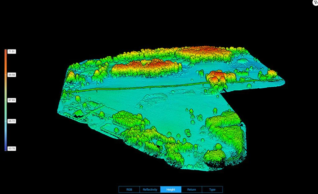
4. Point Cloud Generation
During data processing workflow:
- Raw trajectory is calculated
- Laser returns are matched with position data
- A dense 3D point cloud is generated
Each point contains X, Y, Z coordinates and often intensity values.
5. Ground Classification
During LiDAR data processing, ground classification algorithms separate terrain points from vegetation, buildings, and infrastructure. This step enables accurate Digital Terrain Model (DTM) generation and improves elevation reliability.
Specialized algorithms classify points into categories:
- Ground
- Vegetation
- Buildings
- Infrastructure
This step enables accurate terrain extraction.
6. Surface Modeling (DTM / DSM)
After ground classification, surface modeling is performed to generate elevation-based outputs from the processed point cloud. These models represent terrain and surface geometry in a structured and engineering-ready format.
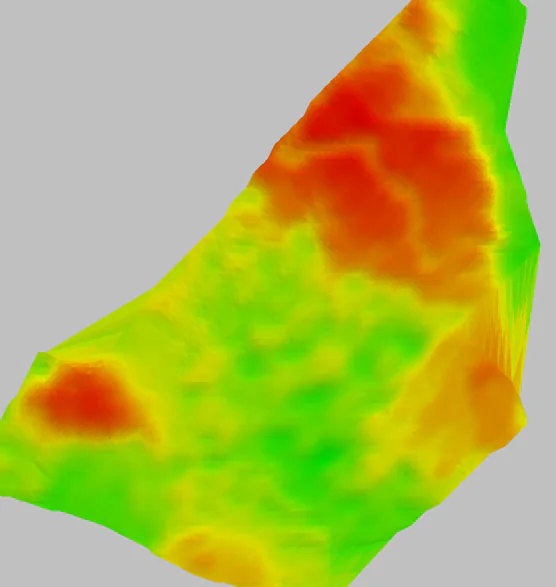
From classified data:
- DSM (Digital Surface Model) includes buildings and vegetation
- DTM (Digital Terrain Model) represents bare earth
These models form the basis for contour maps and engineering design.
LiDAR Drone Mapping vs Photogrammetry
| Feature | LiDAR Drone Mapping | Photogrammetry |
| Measurement Type | Laser pulse distance | Image matching |
| Vegetation Penetration | Yes | No |
| Lighting Dependency | Minimal | High |
| Surface Texture Requirement | None | Requires contrast |
| Performance in Dense Forest | High | Limited |
| Corridor Mapping Efficiency | Excellent | Moderate |
LiDAR drone mapping is particularly advantageous in wooded, uneven, or low-contrast environments where image-based mapping struggles.
Applications of LiDAR Drone Mapping
LiDAR drone survey technology supports a wide range of industries.
Construction Sites
- Earthwork volume calculations
- Site grading validation
- Progress monitoring
For property development projects, integrated drone site survey services provide detailed terrain data to support planning and design decisions.
Infrastructure Corridors
- Road and highway mapping
- Railway corridors
- Transmission lines
- Pipeline routes
Drone-based LiDAR is ideal for long linear assets.
For large-scale infrastructure and land development projects, aerial LiDAR mapping services provide reliable terrain intelligence for engineering teams.
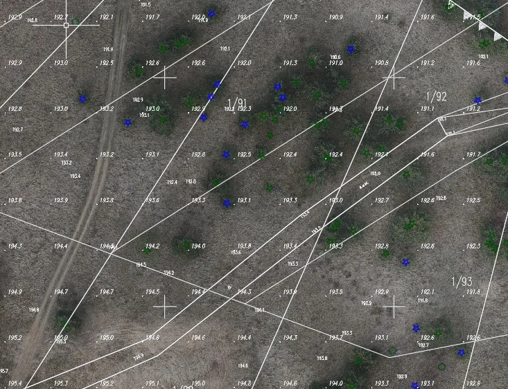
Topographic Surveys
- High-resolution contour mapping
- Floodplain analysis
- Hydrological modeling
Urban Planning
- 3D city models
- Surface analysis
- Utility planning
Forestry
- Canopy height modeling
- Biomass estimation
- Vegetation structure analysis
Mining
- Stockpile volume calculation
- Pit monitoring
- Terrain change detection
Accuracy of LiDAR Drone Surveys
Drone LiDAR surveys typically achieve:
- Vertical accuracy: ±3–5 cm
- Horizontal accuracy: 2–5 cm (depending on system and control)
Accuracy depends on:
RTK vs PPK
Both correction methods enhance positioning accuracy. PPK often provides greater flexibility and reliability in complex environments.
Ground Control Points (GCPs)
Although UAV LiDAR can operate with minimal ground control, GCPs improve validation and error mitigation.
Error Margins
Accuracy is influenced by:
- Flight altitude
- Sensor calibration
- IMU quality
- Processing methodology
It is important to note that drone-based LiDAR does not deliver millimeter-level precision typical of terrestrial laser scanning systems.
Deliverables from LiDAR Drone Mapping
A professional aerial LiDAR mapping project produces structured, engineering-ready datasets derived from classified point cloud processing and surface modeling workflows.
A professional aerial LiDAR mapping project produces several standardized outputs:
- Classified LAS / LAZ files
- Digital Terrain Model (DTM)
- Digital Surface Model (DSM)
- Contour maps
- CAD-ready files
- 3D terrain model
For projects requiring geometry verification and structural documentation, drone-based LiDAR data is often integrated into drone as-built surveys to validate constructed conditions against design models.
These deliverables support engineers, planners, architects, and GIS specialists in design and analysis workflows.
When to Choose LiDAR Drone Mapping
LiDAR drone mapping is especially suitable for:
Large Areas
Efficient coverage of hundreds of acres in a single mission.
Vegetated Terrain
Multi-return capability enables accurate ground classification beneath tree canopy.
Hard-to-Access Zones
Steep slopes, wetlands, and remote regions can be surveyed safely.
Corridor Mapping
Highway, railway, and utility line mapping benefit from consistent swath coverage and reliable elevation modeling.
FAQ
What is lidar drone mapping?
LiDAR drone mapping is a surveying method that uses UAV-mounted laser scanners to collect 3D elevation data and generate accurate terrain models.
How accurate is drone LiDAR?
Typical vertical accuracy ranges between ±3–5 cm, depending on system configuration, RTK/PPK correction, and processing workflow.
Is LiDAR better than photogrammetry?
LiDAR performs better in vegetated areas, low-texture environments, and complex terrain. Photogrammetry may be suitable for visual modeling but lacks vegetation penetration capability.
Is LiDAR better than photogrammetry?
LiDAR performs better in vegetated areas, low-texture environments, and complex terrain. Photogrammetry may be suitable for visual modeling but lacks vegetation penetration capability.
How much does LiDAR drone mapping cost?
Costs vary depending on project size, terrain complexity, required point density, and deliverables. Corridor projects and dense forest mapping may require more advanced processing.
Can LiDAR see through trees?
LiDAR does not “see through” objects in the visual sense. However, multiple laser returns allow ground detection beneath vegetation canopy, enabling accurate bare-earth modeling.