Drone Site & Property Survey Services

Drone land surveying is no longer an experimental technology, it is a production-grade data acquisition method used across construction, architecture, and engineering projects worldwide. At ScanM2 we provide professional drone land surveying services engineered specifically for BIM-based workflows, construction planning, and technical decision-making.
Our drone site survey services are built around precision, repeatability, and integration. Every dataset we deliver is processed, validated, and structured to be immediately usable in CAD and BIM environments—without additional interpretation or rework.
Drone Land Surveying Services for Construction
Our drone land surveying for construction combines high-resolution aerial data capture with precise photogrammetric processing.
Key capabilities:
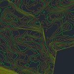
- Topographic surveys and contour mapping
- Orthomosaic generation and digital surface models (DSM)
- Digital terrain models (DTM) for earthworks planning
- Volume calculations (cut & fill)
- As-built verification and progress monitoring
As a drone land surveying company, ScanM2 ensures reliable data accuracy suitable for engineering-grade analysis. Clients can confidently hire drone land surveying services for both early-stage feasibility studies and active construction sites.
Drone Site Survey Services
Our drone site survey services are designed for complex and large-scale environments where traditional methods are time-consuming or impractical.
Applications include:
- Pre-construction site assessment
- Access road and utility corridor surveys
- Commercial drone site survey for industrial facilities
- Drone site survey for construction logistics and planning
As a drone site survey company, we operate compliant UAV platforms and standardized workflows to deliver consistent, repeatable results.
Drone Property Survey Services
ScanM2 offers professional drone property survey services for developers, asset managers, and commercial property owners.
Drone property survey deliverables:
- Boundary visualization and site context mapping
- Roof and façade inspection support
- Commercial drone property survey for large land parcels
- High-resolution imagery for documentation and reporting
Working with a dedicated drone property survey company ensures fast turnaround without compromising technical accuracy.
Drones and Land Surveying Services
The integration of drones and land surveying enables faster data acquisition and enhanced spatial resolution.
Benefits of professional drones and land surveying:
- Reduced on-site labor and safety risks
- Access to hard-to-reach or hazardous areas
- Scalable surveys for large construction zones
- Data compatibility with BIM, CAD, and GIS systems
Our drones and land surveying for construction workflows support engineers, architects, and planners at every project stage.
Drones for Site Surveys
Using professional drones for site surveys, ScanM2 captures precise aerial datasets optimized for engineering analysis.
Commercial drones for site surveys are ideal for:
- Infrastructure corridors
- Industrial plants
- Large-scale commercial developments
- Urban construction sites
Our drones for site surveys services ensure consistent data quality under defined accuracy tolerances.
Using Drones for Land Surveying
Using drones for land surveying services allows rapid coverage of extensive areas with centimeter-level accuracy when combined with ground control points (GCPs).
Professional land surveying using drones supports:
- Feasibility studies
- Design validation
- Construction progress tracking
- Final as-built documentation
ScanM2 specializes in using drones for land surveying in construction, delivering survey-grade outputs ready for engineering use.
How Drone Site & Property Surveys Are Used in Real Projects
Our LiDAR Scanning Results


Using Drones for Surveying
Our using drones for surveying services combine UAV flight planning, photogrammetry, and quality control.
Professional drone surveying services include:
- Aerial data capture
- Point cloud generation
- Orthophoto and elevation models
- CAD and BIM-compatible deliverables
We also provide commercial drone surveying services for large-scale and multi-phase projects.
Drones and Surveying Services by ScanM2
As a provider of drones and surveying services, ScanM2 focuses on technical accuracy, regulatory compliance, and efficient project delivery. Our professional drones and surveying approach ensures reliable results for construction and commercial applications.
FAQ
What is drone land surveying?
Is drone site surveying suitable for construction projects?
How accurate are drone surveying services?
Can I hire drone land surveying services for commercial projects?
Are drone survey outputs compatible with CAD and BIM?
Hire Drone Site Survey Services from ScanM2
If you are looking to hire drone land surveying services, partner with a drone site survey company that understands construction workflows, BIM requirements, and engineering accuracy.
ScanM2 delivers professional drones and surveying services that integrate seamlessly into your project pipeline.
Contact our team to discuss technical requirements, timelines, and deliverables.