3D Laser Scanning for Open-pit quarries

Open-pit quarries require accurate spatial data for planning, measurement, modernization, and infrastructure control. In active quarry operations, terrain changes continuously, haul roads are reworked, benches shift after excavation, and plant areas are often modified over time. 3D laser scanning for open-pit quarries provides a reliable way to capture actual site conditions and turn them into engineering-ready data.
For quarry operators, contractors, and engineering teams, this means better control over pit geometry, quarry infrastructure, processing zones, and site layouts before design, reconstruction, or upgrade work begins.
Contact Us Now for a Free Consultation!
3D Laser Scanning Services for Open-Pit Quarries
Our laser scanning services for open-pit quarries are used to document terrain, quarry infrastructure, plant areas, and operational zones with high geometric accuracy. The goal is not just to collect scan data, but to provide a clear digital basis for planning and technical decision-making.
This service is typically used for:
- existing-condition documentation
- quarry plant upgrades
- haul road and slope analysis
- infrastructure expansion
- stockpile and surface measurement
- conveyor and plant layout verification
- reconstruction planning
- preparation for digital engineering workflows
What Can Be Scanned in Open-Pit Quarry Environments
A quarry scanning scope may include the following areas:
- pit walls and benches
- haul roads and access routes
- stockpiles and excavation zones
- crushers and screening areas
- conveyors and transfer structures
- processing plants and support steel
- drainage systems and site utilities
- industrial platforms, stairs, and access zones
Depending on project needs, the work may focus on one critical area or cover the full quarry and plant environment.
Why 3D Laser Scanning Is Used in Open-Pit Quarries
Open-pit quarries create conditions where traditional measurement methods are often too slow, too limited, or too difficult to apply across large and changing areas. Laser scanning allows engineering teams to work with detailed site geometry instead of fragmented measurements or outdated drawings.
This is especially important when:
- terrain geometry changes after extraction or blasting
- plant infrastructure has been modified over time
- conveyor alignments need verification
- stockpiles and surfaces require accurate measurement
- access routes and gradients must be reviewed
- expansion or reconstruction is planned in active operating conditions
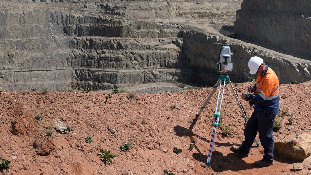
3D Laser Scanning for Benches, Haul Roads, and Quarry Terrain
In open-pit quarries, terrain geometry directly affects planning, safety, and production control. Scanning of pit walls, benches, haul roads, and excavation areas provides current data for engineering review and operational assessment.
This is commonly used for:
- slope and geometry verification
- haul road gradient analysis
- terrain comparison over time
- stockpile and excavation measurement
- planning of earthworks and site changesё
For large quarry sites, this gives teams a much clearer picture of current conditions than legacy topographic records alone.
3D Laser Scanning for Quarry Plants, Conveyors, and Infrastructure
Beyond terrain, quarry operations also depend on accurate documentation of fixed industrial assets. Plant layouts, crushers, conveyors, transfer points, support steel, and service structures must often be measured before modification or expansion.
Laser scanning of quarry plant areas is used for:
- conveyor alignment review
- crusher and screening area documentation
- support structure verification
- transfer point measurement
- plant layout checks before upgrades
- preparation for new equipment integration
Where needed, scan data from these areas can later support Point Cloud Processing, Scan to BIM, BIM Modeling, or As-Built Drawings.
What Makes Scanning in Open-Pit Quarries Different
Quarry environments require a different scanning approach than enclosed industrial sites. Open terrain, multiple elevation levels, blasting zones, dust, and heavy equipment movement all affect how fieldwork is planned and executed.
Key technical considerations usually include:
- large scanning ranges across uneven terrain
- variable weather and visibility conditions
- moving machinery within active production areas
- difficult access to some pit or plant zones
- the need for georeferenced data tied to project coordinates
- filtering of unwanted objects during data processing
Because of these conditions, field planning and scan control are critical to achieving usable results.
Engineering Uses of Quarry Scan Data
3D scan data from open-pit quarries is used in a range of engineering and operational tasks, including:
- volume calculation and material tracking
- quarry plant upgrade planning
- terrain and slope review
- conveyor and infrastructure redesign
- existing-condition verification
- layout analysis for equipment relocation
- reconstruction of transfer and support areas
- long-term asset documentation
The value of the scan is not just in the captured geometry, but in how that geometry supports planning, review, and decision-making.
Table: Typical Deliverables for Open-Pit Quarry Laser Scanning
| Deliverable | Practical Use |
| Registered point cloud | Base dataset for engineering and design review |
| Georeferenced scan data | Alignment with site coordinates and existing records |
| Digital terrain model | Terrain analysis, planning, and measurement |
| Cross-sections and profiles | Slope review, elevation checks, and route analysis |
| Plant area scan dataset | Quarry plant upgrades and infrastructure verification |
| Existing-condition documentation | Base information for reconstruction and future engineering work |
3D Laser Scanning for Quarry Modernization and Expansion
For modernization and expansion projects, scanning provides a practical starting point. Instead of relying on incomplete drawings or isolated field measurements, project teams can work from a full spatial dataset of the existing quarry and plant environment.
This is especially useful before:
- adding or extending conveyors
- upgrading crushers or plant equipment
- modifying support structures
- reworking access roads or plant routes
- preparing design inputs for digital engineering
- documenting existing conditions before phased reconstruction
3D laser scanning for open-pit quarries gives operators and engineering teams accurate site data for terrain review, quarry infrastructure control, and plant planning. For pit geometry, haul roads, conveyors, processing zones, and support structures, scan data provides a more reliable basis for technical decisions in active quarry environments.
FAQ
What is included in 3D laser scanning for an open pit quarry?
It includes scanning of terrain, benches, quarry infrastructure, haul roads, and processing facilities such as crushers and conveyors. The result is a complete spatial dataset of the mining site.
How accurate is laser scanning in quarry environments?
Accuracy typically ranges from a few millimeters to centimeters depending on distance and conditions. Proper planning and data processing ensure reliable results even in challenging environments.
Can scanning be performed without stopping quarry operations?
Yes. Laser scanning is a non-contact method and can be conducted while the quarry remains operational, with proper safety coordination.
How is the data used after scanning?
The data is used for volume calculations, design planning, equipment layout analysis, and creation of digital models or as-built documentation.
Is laser scanning suitable for large open pit mining facilities?
Yes. It is specifically well-suited for large-scale environments due to its ability to capture extensive areas quickly and accurately.