3D Laser Scanning for Land Survey & Site Analysis

At ScanM2, we provide high-precision 3D laser scanning for land survey, site analysis, terrain mapping, and digital site documentation. Using cutting-edge technology from Faro, Leica, and Trimble, we deliver detailed 3D models, point clouds, and 2D drawings in formats like .rvt, .dwg, .pln, .pla, and more. Our services help architects, engineers, and construction professionals streamline projects with unmatched accuracy and efficiency.
Why Choose 3D Laser Scanning for Land Survey and Site Analysis?
Key Benefits of Our Technology:
- Unmatched Accuracy: Capture site conditions with millimeter precision, eliminating human errors common in traditional surveying methods.
- Time Efficiency: Faster data collection than traditional surveying methods, reducing the need for repeat site visits and manual re-measurements.
- Comprehensive Documentation: Generate 3D models, point clouds, and digital site maps that can be easily referenced for future modifications and project planning.
- Cost-Effective Solutions: More affordable than manual scanning while delivering superior detail, helping you optimize project budgets and minimize unexpected expenses.
- Enhanced Safety: Minimizes risks associated with manual surveying in hazardous or hard-to-reach locations.
- Versatility: Ideal for construction sites, infrastructure projects, historical preservation, and more, ensuring a broad range of applications across various industries.
- Non-Intrusive Technology: No need to halt ongoing construction or disrupt site operations; scanning is quick, efficient, and non-invasive.
Where Our Services Apply:
- Topographic Surveys: Accurate elevation and terrain mapping crucial for civil engineering and landscape design.
- Construction Site Surveys: Plan and manage construction phases effectively with precise digital models.
- Digital Site Mapping: Create detailed, data-rich representations for urban planning, property assessments, and environmental studies.
- Building Renovation & Restoration: Document existing structures with precision for seamless remodeling and historical preservation projects.
- Industrial Site Documentation: Essential for plant expansions, safety compliance, and factory floor optimization.
- Transportation & Infrastructure: Generate as-built documentation for roads, bridges, and tunnels, aiding in maintenance and future expansion planning.
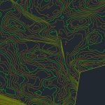
Our Land Survey Results


Our 3D Laser Scanning Process
How We Work:
- Project Assessment: We evaluate your site requirements, considering factors such as size, complexity, and final deliverables.
- On-Site Scanning: Using industry-leading Faro, Leica, or Trimble scanners, our team captures thousands of precise data points.
- Data Processing & Analysis: Convert raw scans into accurate 3D models, point clouds, and CAD files, removing noise and ensuring clarity.
- Quality Control & Optimization: We refine models, ensuring all relevant site details are accurately represented.
- Delivery & Support: Provide files in all required formats, with expert consultation on how to use the data for your project’s needs.
Factors Affecting Pricing:
- Site Size & Complexity: Larger or more complex sites require additional scanning time and processing efforts.
- Indoor vs. Outdoor Scanning: The environment impacts scanning techniques and equipment usage.
- Data Output Requirements: Choose between point clouds, 2D documentation, or 3D models based on project scope.
- Additional Features: Inclusion of utilities, lighting, HVAC, plumbing, and structural reinforcements affects cost and processing time.
Misconception Alert
Many believe 3D laser scanning is expensive, but at ScanM2, we provide affordable pricing compared to competitors using manual scanners—without compromising on precision. Investing in laser scanning can save significant costs by avoiding rework, minimizing material waste, and reducing project delays.
Why Choose ScanM2 for Your Surveying Needs?
Our Competitive Advantages:
- Latest Technology: Industry-leading Faro, Leica, and Trimble scanners, ensuring the highest levels of accuracy and efficiency.
- Affordable Pricing: Lower cost than manual scanning competitors, allowing businesses of all sizes to access cutting-edge solutions.
- Versatile Deliverables: Receive data in .rvt, .dwg, .pln, .pla, and other formats for seamless integration into your existing workflows.
- Fast Turnaround: Optimized workflows for quick project completion, enabling you to meet tight deadlines.
- Expert Team: Our specialists have years of experience in laser scanning, land surveying, and digital mapping, ensuring professional and reliable service.
- Nationwide Service: Available across the USA, covering urban, suburban, and remote project locations with ease.
- Scalable Solutions: Whether you need a small residential survey or a large-scale industrial site scan, we tailor our services to fit your specific needs.
Frequently Asked Questions
How accurate is 3D laser scanning for land surveys?
How long does the scanning process take?
What output formats do you provide?
Is laser scanning cost-effective?
What industries benefit from 3D laser scanning?
Get Started with Precision 3D Laser Scanning Today!
Fill out our form below to request a free consultation and get a custom quote for your project. Our team at ScanM2 is ready to help you achieve high-precision land surveys and site analysis with cutting-edge 3D laser scanning technology.
Request a Free Quote!