LiDAR Scanning in Colorado: Precision 3D Scanning Solutions
At ScanM2, we provide professional LiDAR scanning services in Colorado to create highly accurate 3D models, point clouds, and detailed 2D/3D documentation for buildings, structures, factories, and other complex objects. Using cutting-edge Faro, Leica, and Trimble scanners, we deliver precise results tailored to your needs—whether you require point clouds, 2D plans, or full 3D models.
What is LiDAR Scanning and Why Do You Need It?
LiDAR (Light Detection and Ranging) is a cutting-edge technology that uses laser beams to create accurate and highly detailed 3D representations of objects, buildings, and surrounding environments. By scanning spaces both indoors and outdoors, our team gathers data with unmatched precision.
Whether you are an architect, engineer, construction manager, or business owner, LiDAR scanning ensures:
- High accuracy: Eliminates human errors in measurements.
- Efficiency: Reduces manual effort and saves time.
- Detailed visualization: Generates 3D models, point clouds, and drawings in various formats like .rvt, .dwg, .pln, and .pla.
Our services are perfect for:
- Building renovations and restorations
- Infrastructure projects
- Factory planning and design
- Heritage site preservation
- Industrial equipment modeling
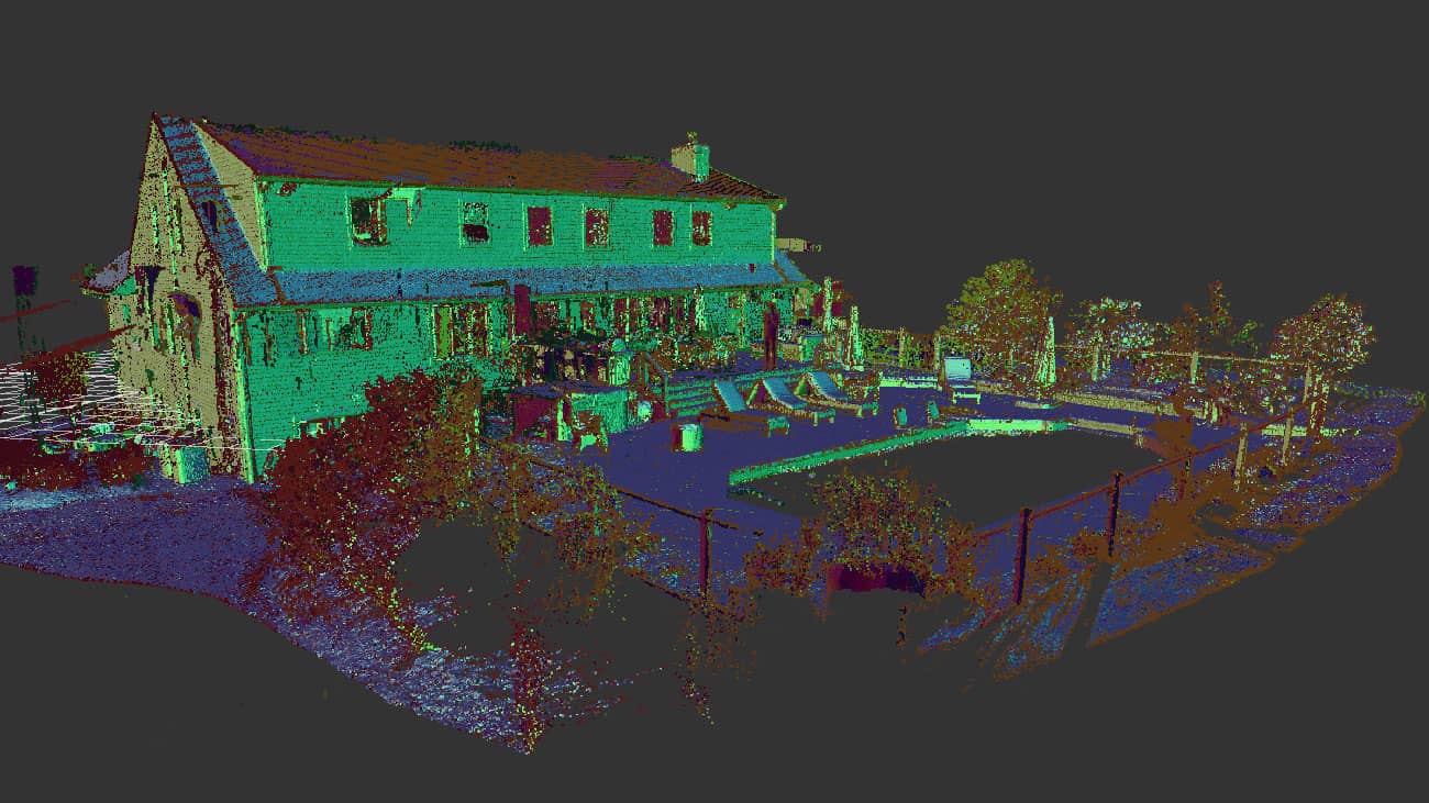
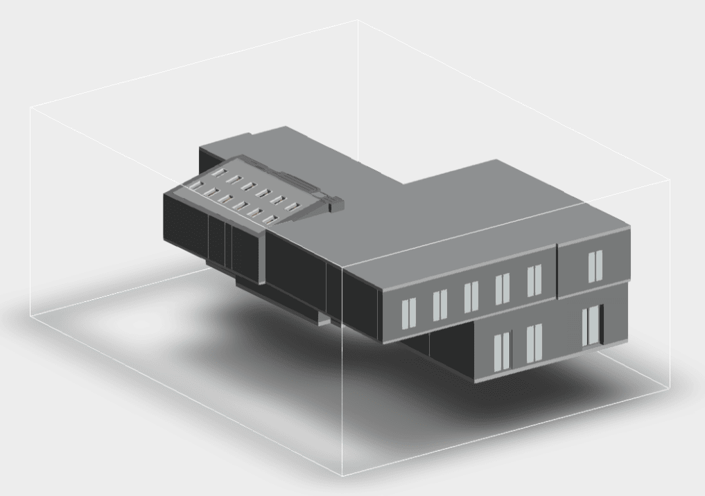
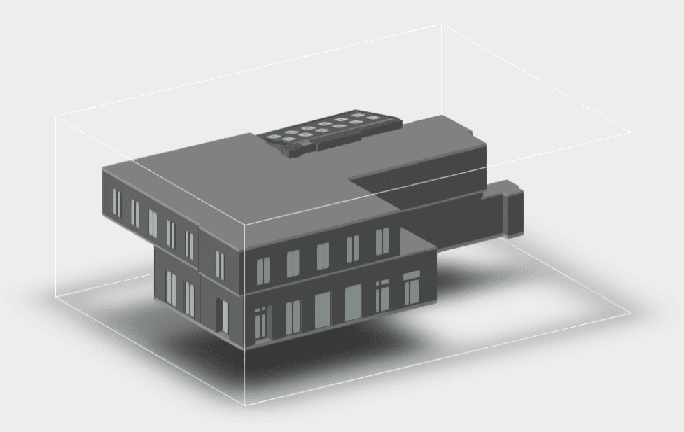
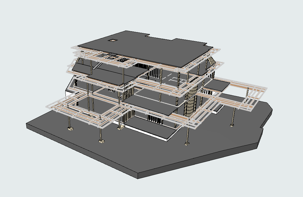
Our LiDAR Scanning Examples


Advantages of LiDAR in Colorado
LiDAR scanning offers many benefits that make it the preferred choice for projects requiring accuracy and efficiency.
- Unparalleled Precision: We use the latest scanners—Faro, Leica, and Trimble—that capture even the smallest details with millimeter-level accuracy. This ensures reliable data for all applications.
- Cost Savings: Contrary to common belief, LiDAR scanning doesn’t have to be expensive. At ScanM2, we offer a more cost-efficient solution compared to competitors who still depend on manual scanning techniques. The efficiency of LiDAR significantly reduces costs without compromising quality.
- Versatility Across Projects: LiDAR scanning is suitable for any object or space:
- Indoor and outdoor environments
- Factories, warehouses, and residential buildings
- Complex industrial infrastructure
- Faster Project Timelines: We quickly collect large volumes of data, speeding up design and construction processes while minimizing project delays.
Our Work Process
At ScanM2, we deliver a streamlined, efficient workflow to ensure customer satisfaction and project success.
- Consultation and Needs Assessment: We start by analyzing your project needs—identifying the object type, area size, and determining if scanning is required for interiors, exteriors, or both. We also determine the output you require: point clouds, 2D documentation, or 3D models.
- Data Collection: Our team uses professional LiDAR scanners to capture accurate laser scans of the space or object.
- Data Processing: We convert the scanned data into practical formats, including: .rvt, .dwg, .pln, and .pla, ensuring seamless integration into your preferred software (Revit, AutoCAD, ArchiCAD, etc.).
- Delivery of Results: The final product—whether a 3D model, point cloud, or detailed plan—is delivered promptly to meet your project timeline.
Why Choose ScanM2 for LiDAR Scanning?
Choosing the right partner for LiDAR scanning can make all the difference. Here’s why ScanM2 stands out:
- State-of-the-Art Technology: We employ industry-leading scanners such as Faro, Leica, and Trimble to achieve unmatched accuracy and detail.
- Cost-Effective Solutions: By leveraging advanced technology, we minimize labor costs, offering more affordable services compared to competitors using manual scanning methods.
- Fast Turnaround: We work efficiently to deliver accurate data within tight deadlines.
- Custom Deliverables: You receive the exact output you need—whether it’s point clouds, 2D plans, or full 3D models.
- Experienced Team: Our skilled specialists ensure every detail is accounted for during scanning and data processing.
- Clear Communication: We keep you informed at every stage of the project.
Frequently Asked Questions
What is LiDAR scanning, and how does it work?
LiDAR scanning uses laser technology to map environments in 3D. It emits laser pulses that bounce off surfaces and return to the scanner for measurement. This data is then processed into accurate point clouds or models.
How much does LiDAR scanning cost?
The cost is determined by factors such as the object’s size and type, scanning conditions (indoor, outdoor, or both), and the required final deliverables. At ScanM2, our pricing is competitive and often lower than manual scanning services.
What file formats do you offer?
We deliver outputs in formats like .rvt, .dwg, .pln, and .pla, guaranteeing smooth integration with top software platforms such as Revit, AutoCAD, and ArchiCAD.
What kind of projects benefit from LiDAR scanning?
LiDAR is ideal for construction, renovation, industrial projects, heritage preservation, and factory design. It provides precise data for buildings, infrastructure, and complex environments.
How accurate is your LiDAR scanning?
Our professional scanners ensure millimeter-level accuracy, making LiDAR scanning one of the most reliable methods for data collection.
What is the typical duration of the LiDAR scanning process?
The project timeline is determined by its size and level of complexity. However, LiDAR scanning is significantly faster than manual measurements.
Take the First Step with ScanM2’s LiDAR in Colorado
Ready to unlock the benefits of accurate LiDAR scanning for your project? Complete our form to kick off your project today. Whether you require point clouds, 2D drawings, or 3D models, ScanM2 delivers high-quality results at competitive rates. Let’s bring precision, efficiency, and value to your project!