Professional LiDAR Scanning in Texas
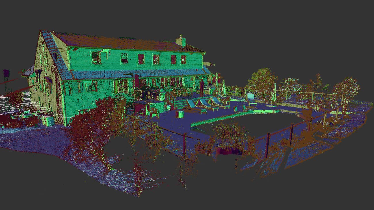
LiDAR (Light Detection and Ranging) is a cutting-edge technology that creates highly accurate 3D models of structures, landscapes, and objects. By utilizing advanced laser scanning systems like FARO, Leica, and Trimble, we provide professional LiDAR services across Texas, tailored to meet your project’s specific needs. Whether you’re looking for point clouds, 2D plans, or 3D models in formats like .rvt, .dwg, .pln, or .pla, we ensure precision and efficiency at every stage.
We serve various industries such as construction, architecture, engineering, and facility management, providing valuable data to support informed decision-making.
Our LiDAR Examples


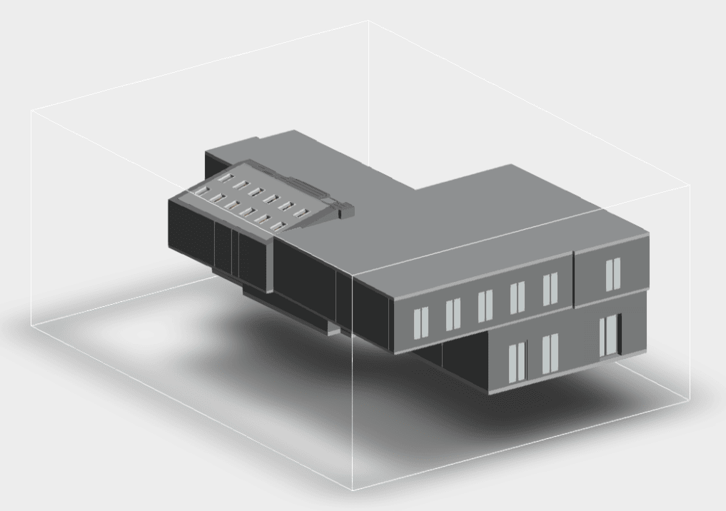
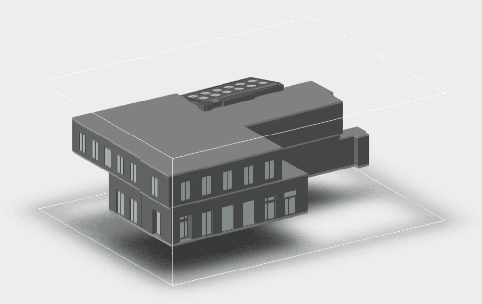

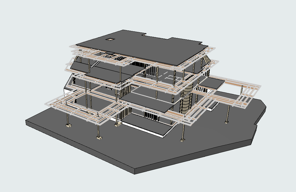


Discover the future of precision mapping and 3D modeling with our state-of-the-art LiDAR scanning solutions in Texas.
The Advantages of LiDAR Scanning
- Unmatched Accuracy: LiDAR scanning captures millions of data points within seconds, offering a level of detail and precision unmatched by traditional measurement methods.
- Time Efficiency: LiDAR allows for rapid data collection, reducing project timelines significantly. Unlike manual methods, which can take days or weeks, our laser scanners complete projects swiftly without compromising quality.
- Diverse Applications: LiDAR scanning is ideal for:
- Building Information Modeling (BIM): Developing accurate and detailed 3D models.
- Surveying and Mapping: Ideal for large-scale infrastructure projects.
- Historical Preservation: Accurately documenting heritage sites.
- Utilities and Infrastructure: Mapping underground and overhead systems like water, sewer, HVAC, and electrical networks.
- Cost-effective solutions: LiDAR scanning is more affordable than many assume. Our services are priced competitively, often costing less than those of competitors using manual scanners, while providing unmatched precision.
How Scanning Works: Our Process
- Initial Consultation: We start by thoroughly discussing your project’s scope, objectives, and desired deliverables.
- Site Survey: Our team uses advanced laser scanners (FARO, Leica, Trimble) to collect comprehensive data. No matter if your project is indoors or outdoors, we ensure every detail is captured with precision.
- Data Processing: The raw data is processed into precise point clouds, which can then be converted into 2D plans, 3D models, or other formats based on your requirements.
- Quality Assurance and Delivery: We perform rigorous quality checks to ensure the final deliverables meet industry standards. We provide all deliverables in the formats you prefer, ensuring seamless integration into your workflows.
Why Choose Our LiDAR Scanning in Texas?
- Cutting-Edge Technology: We utilize top-of-the-line scanners from FARO, Leica, and Trimble to guarantee exceptional detail and precision.
- Expertise and Experience: Our team is made up of seasoned experts with in-depth knowledge of LiDAR scanning and data processing.
- Customized Solutions: Each project is distinct. We customize our services to meet your specific needs, providing deliverables in all major formats compatible with modern software.
- Competitive Pricing: Our streamlined processes and efficient technology allow us to offer LiDAR scanning at a lower cost compared to competitors.
- Comprehensive Support: We manage every stage, from data acquisition to delivering the final 3D model or documentation, with accuracy and attention to detail, providing a hassle-free experience.
Frequently Asked Questions
What is LiDAR scanning, and how does it function?
LiDAR scanning employs laser pulses to calculate distances and generate detailed 3D models of objects, structures, and landscapes. Advanced scanners capture millions of data points in a short time, providing unparalleled accuracy and detail.
How much does LiDAR scanning cost?
The cost depends on factors like the type and size of the site, whether it’s indoors or outdoors, and the desired deliverables (e.g., point cloud, 3D model, or 2D plans). We offer a comprehensive quote following an assessment of your project.
Who can benefit from LiDAR scanning?
LiDAR scanning is invaluable for construction, architecture, engineering, facility management, urban planning, and heritage preservation, among other fields.
What file formats can you deliver?
We provide deliverables in widely used formats like .rvt, .dwg, .pln, .pla, and other formats to guarantee compatibility with your current tools and software.
Is LiDAR scanning suitable for small projects?
Absolutely. LiDAR scanning is versatile and can be tailored to projects of any scale, from a single structure to a large industrial facility.
How does LiDAR scanning’s precision measure up against traditional techniques?
LiDAR scanning offers far greater accuracy, capturing fine details that are often overlooked by traditional methods.
Contact Us for LiDAR in Texas
Ready to experience the precision and efficiency of LiDAR scanning? Fill out our online form now to schedule a consultation or request a custom quote. Our team is committed to bringing your vision to life through accurate, affordable, and customized solutions. Choose precision. Choose affordability.
Choose us for your LiDAR scanning needs in Texas.