3D Laser Scanning and Detailed BIM Modeling of a Historic Mansion in Connecticut
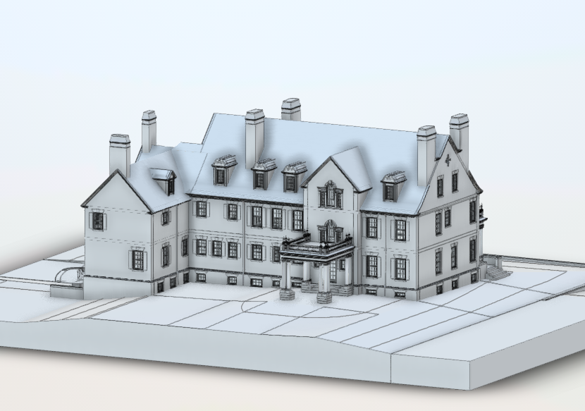
We carried out high-precision laser scanning and detailed BIM modeling of a historic mansion located in Barrington, Connecticut. The project focused on accurately capturing the geometry of the building’s facades and recreating the architectural elements in a highly detailed 3D Revit model.
The mansion features complex architectural geometry and numerous decorative components, including railings, ornamental details, shutters, balconies, and decorative window structures. To accurately document these elements, terrestrial laser scanning technology was used to capture the building geometry with millimeter-level precision.
Based on the collected data, a complete point cloud was generated and used as the foundation for developing a high-detail BIM model. The resulting deliverables provide architects and engineers with reliable documentation for renovation, restoration, and design planning.
Project Overview

Project Type: 3D laser scanning and detailed BIM modeling of mansion facades
Location: Barrington, Connecticut, USA
Building Type: Historic residential mansion
Total Area: Approximately 15,000 sq ft
Project Goal:
Perform high-precision scanning of the mansion facades and develop a detailed Revit BIM model with LOD 400–500, including architectural elevations.
Final Deliverables
• Point cloud dataset
• 3D Revit model (LOD 400–500)
• Architectural elevation drawings
• Exported files in RVT, DWG, and PDF formats
The key objective of the project was to reproduce the real building geometry with high accuracy while maintaining detailed modeling of architectural elements.
Project Challenges
Complex Architectural Geometry
Historic mansions often contain irregular facade structures, decorative architectural elements, and non-standard geometry. The building in Barrington included multiple balconies, detailed window structures, decorative railings, and facade ornaments that required careful measurement and modeling.
High Level of Detail
Because the final model required LOD 400–500, the modeling process needed to capture fine architectural details, including facade elements and decorative components.
Site Conditions
Scanning operations were conducted directly on the mansion grounds. Some elements, including decorative balconies and facade details, required careful positioning of scanning stations to capture the geometry accurately.
Technical Data and Accuracy
The project was performed using terrestrial laser scanning technology to capture the entire building geometry.
Measurement Method: Terrestrial Laser Scanning (TLS)
Data Processing:
• Point cloud generation and alignment
• Processing of scanning data
• Preparation of a unified point cloud model
Accuracy: ±4 mm
The resulting point cloud provided a complete and accurate digital representation of the building geometry and architectural features.
Methodology
1. Field Laser Scanning
The project began with terrestrial laser scanning of the mansion, including the main facade and architectural elements such as balconies, windows, and decorative structures.
Multiple scanning positions were used to ensure complete coverage of the building geometry.
2. Point Cloud Processing
After the field measurements, the collected scans were processed and combined into a single unified point cloud.
The processing stage included:
• Registration of individual scans
• Alignment and accuracy verification
• Preparation of the dataset for BIM modeling
3. BIM Model Development
Using the prepared point cloud as the reference base, a detailed 3D BIM model was developed in Autodesk Revit.
The model included accurate reproduction of:
• facade geometry
• decorative elements
• balconies and railings
• windows and architectural components
The final model achieved LOD 400–500, enabling a high level of architectural detail.
4. Quality Control
Internal verification procedures were conducted to ensure the model accurately represented the real geometry captured during scanning.
The project scope and modeling details were coordinated with the architect and project stakeholders.
5. Documentation Preparation
Based on the completed BIM model, architectural elevation drawings were generated.
Final documentation was exported in the following formats:
• RVT
• DWG
• PDF
Results

Complete Point Cloud Dataset
A detailed point cloud of the mansion was created, representing the actual building geometry and architectural features with high accuracy.
The dataset provides a reliable base for architectural design and engineering analysis.
High-Detail BIM Model
A detailed 3D Revit model (LOD 400–500) was developed based on the scanning data. The model accurately represents the building’s facade elements and architectural features.
Architectural Elevation Documentation
Using the BIM model, a complete set of 2D elevation drawings was generated. These drawings reflect the real geometry of the building and can be used for renovation planning and architectural documentation.
Project Benefits
Accurate representation of the real building
The laser scanning approach ensures that the BIM model reflects the exact geometry of the existing structure.
High level of architectural detail
LOD 400–500 modeling allows designers to analyze architectural components and decorative elements in detail.
Reliable design base
The delivered documentation enables architects and engineers to plan renovation and restoration work with confidence.