3D Laser Scanning services in Washington for Construction, Architecture, and BIM

Accurate existing-conditions data is a critical foundation for modern design, construction, and renovation projects. 3D laser scanning services in Washington provide engineering-grade documentation of buildings, structures, and infrastructure with millimeter-level precision. Using terrestrial laser scanners, project teams capture millions of data points per second, generating precise point clouds that support BIM, CAD, and coordination workflows.
In a market where schedules are compressed and rework is costly, laser scanning services eliminate uncertainty associated with outdated drawings, undocumented field modifications, and complex MEP systems. For architects, engineers, contractors, and owners, this technology delivers reliable geometry that directly supports design validation, clash detection, and constructability analysis.
Why 3D Laser Scanning Is in High Demand in Washington
Washington State remains one of the most active construction and renovation markets in the U.S. Continuous investment in commercial development, infrastructure upgrades, and tenant improvement projects drives demand for accurate as-built data.
A significant share of this activity involves existing buildings where original documentation is incomplete or unreliable. Renovations often uncover undocumented structural changes, congested mechanical rooms, and legacy systems that are difficult to measure manually. In these conditions, 3D laser scanning Washington projects rely on deliver consistent, survey-grade data that reduces project risk, shortens design cycles, and minimizes site revisits.
According to McKinsey, rework caused by inaccurate or missing information can account for up to 30% of total construction costs on complex projects. Laser scanning directly addresses this issue by establishing a single, verifiable source of truth.
What Are 3D Laser Scanning Services?
Laser scanning services use LiDAR-based equipment to capture the exact geometry of physical environments. The result is a dense point cloud that represents walls, floors, ceilings, structural elements, and MEP systems in true spatial relationships.
Core Deliverables
- Registered point clouds (E57, RCP, RCS)
- 2D CAD drawings (DWG)
- BIM models (RVT)
- IFC models for openBIM workflows
Typical accuracy for professional 3d scan service near me providers is ±2 mm, suitable for architectural, structural, and MEP coordination.
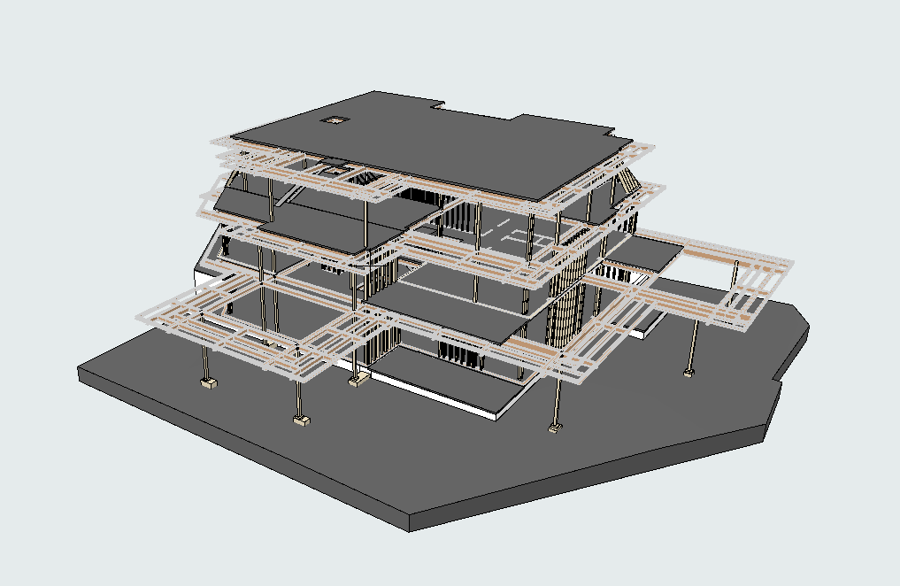
3D Building Scanning Services
Comprehensive As-Built Documentation
3D building scanning services focus on capturing complete interior and exterior conditions of existing structures. This includes architectural layouts, structural framing, and visible mechanical, electrical, and plumbing systems.
Unlike traditional field surveys, scanning captures all geometry simultaneously, reducing human error and ensuring no critical elements are missed.
Typical Use Cases
- Renovation and adaptive reuse projects
- Tenant improvement and fit-out design
- Structural retrofit and seismic upgrades
- Facility management and lifecycle documentation
According to Autodesk, projects using scan-to-BIM workflows report up to 50% reduction in design conflicts during construction phases.
Laser Scanning Workflow
1. Pre-Scan Planning
Scan locations, resolution requirements, and control targets are defined based on project scope and required accuracy.
2. Field Data Capture
High-resolution terrestrial scanners collect millions of points per second. Minimal site disruption allows scanning during active building operations.
3. Registration and Quality Control
Individual scans are registered into a unified coordinate system. Accuracy checks ensure tolerance compliance.
4. Modeling and Documentation
Point clouds are converted into CAD drawings or BIM models aligned with client standards and LOD requirements.
Comparison: Traditional Survey vs 3D Laser Scanning
| Parameter | Traditional Survey | 3D Laser Scanning Services |
|---|---|---|
| Accuracy | ±10–20 mm | ±2 mm |
| Data Density | Selective measurements | Full-field capture |
| Field Time | Multiple visits | Single visit in most cases |
| BIM Readiness | Limited | Direct Scan-to-BIM |
| Risk of Missing Data | High | Minimal |
This comparison highlights why many 3d scanning companies near me are now the standard choice for complex projects.
Applications Across Washington Projects
Commercial and Office Buildings
Accurate floor plans and MEP layouts support efficient tenant improvements and phased renovations.
Industrial and Manufacturing Facilities
High-density scanning captures congested pipe racks, equipment foundations, and steel structures for retrofit planning.
Infrastructure and Public Facilities
Laser scanning supports coordination in transportation hubs, campuses, and healthcare facilities with minimal operational downtime.
Choosing 3D Laser Scanning Services in Washington
When selecting 3D laser scanning services in Washington, technical capability, local project experience, and data quality matter more than speed alone. For construction, architectural, and infrastructure projects across the state, it is important to evaluate scanning providers based on accuracy, equipment, and their ability to deliver reliable as-built and BIM-ready data. Key criteria include:
- Proven ±2 mm accuracy
- Experience with BIM and CAD standards
- Clear QA/QC procedures
- Ability to deliver RVT, DWG, and IFC formats
Professional building scanning services integrate seamlessly into design and construction workflows rather than functioning as isolated survey tasks.
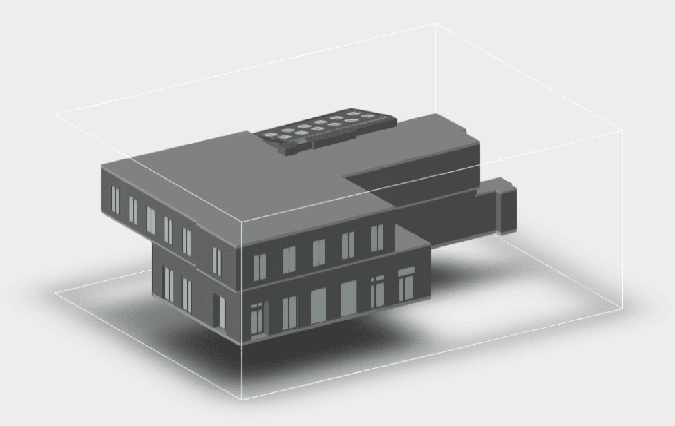
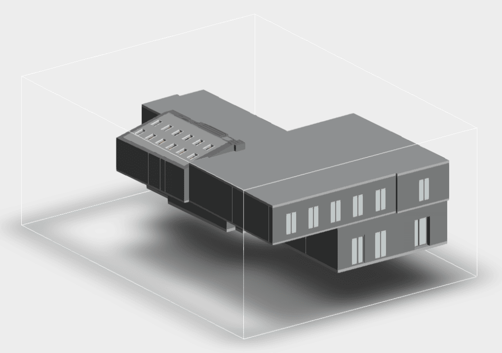
3D Laser Scanning Projects in Washington
Our As Built Services in Washington Examples


3D Laser Scanning Services Pricing in Washington
Pricing for 3D laser scanning services in Washington depends on technical scope, required accuracy, building complexity, and final deliverables. Unlike commodity survey services, professional laser scanning is engineered per project and priced based on data quality, processing requirements, and modeling effort.
There is no “flat rate” for reliable 3d scanning Washington projects. Accurate pricing reflects the level of responsibility associated with millimeter-accurate documentation used for design, coordination, and construction decisions.
Key Factors That Affect Cost
Several technical variables directly influence the cost of laser scanning services:
- Building size and geometry
Total square footage, ceiling heights, structural density, and architectural complexity. - Scan density and accuracy requirements
Higher point density is required for MEP-heavy environments, tight tolerances, and fabrication-level coordination. - Level of documentation required
Raw point clouds only, 2D CAD drawings, or full Scan-to-BIM models. - MEP complexity
Congested mechanical rooms, interstitial spaces, and industrial piping increase processing and modeling time. - Site conditions
Occupied buildings, limited access windows, or active operations may affect field logistics.
Cost vs. Value: Why Laser Scanning Pays Off
While 3d laser scanning near me services represent an upfront investment, multiple studies confirm measurable downstream savings.
- According to McKinsey, reducing rework can save up to 15–30% of total project cost on complex builds.
- Autodesk reports that projects using accurate as-built data reduce RFIs by up to 50% during construction.
- AEC industry benchmarks show Scan-to-BIM workflows can shorten design cycles by up to 40%.
When compared to the cost of redesigns, field re-measurements, and construction delays, building scanning servicesconsistently deliver a strong return on investment.
Why Low-Cost Scanning Is Risk
Extremely low pricing often indicates:
- Insufficient scan density
- Poor registration accuracy
- Lack of QA/QC procedures
- Limited BIM and CAD expertise
Inaccurate point clouds or poorly modeled BIM files can introduce more risk than no data at all. Professional 3d scanning companies near me price services based on accountability, not volume.
Getting an Accurate Quote
To receive a reliable estimate for 3D laser scanning services in Washington, project teams should be prepared to provide:
- Approximate square footage
- Building type and use
- Required deliverables (RVT, DWG, IFC)
- Target level of detail (LOD)
- Project timeline and access constraints
A structured scope allows scanning providers to define the correct workflow, accuracy level, and pricing without hidden assumptions.
FAQ
What is the typical accuracy of 3D laser scanning?
Professional services achieve ±2 mm accuracy under controlled conditions.
Can scanning be done in occupied buildings?
Yes. Most projects are completed with minimal disruption.
What formats are supported?
Common deliverables include RVT, DWG, IFC, and registered point clouds.
How long does a typical project take?
Field scanning often takes 1–2 days, depending on size and complexity. Modeling timelines vary by LOD.
Conclusion
igh-quality 3D laser scanning services in Washington are no longer optional for complex renovation and construction projects. They provide precise, reliable data that directly supports better design decisions, reduces risk, and ensures more predictable project outcomes.
For teams requiring dependable 3d building scanning services, laser scanning remains the most efficient method to capture existing conditions with engineering-level accuracy and confidence.
Get Started with ScanM2
If you are looking for 3D laser scanning services in Washington, ScanM2 delivers precise, construction-ready data you can rely on.