LiDAR Scanning in BIM Modeling: Transforming Modern Architecture and Construction


As technology continues to revolutionize architecture and construction, LiDAR scanning is emerging as a game-changer in Building Information Modeling (BIM). By merging the accuracy of laser scanning with the capabilities of digital modeling, this cutting-edge method is transforming the processes of designing, constructing, and maintaining buildings. Thanks to advancements in LiDAR technology, professionals can now reach unprecedented levels of precision and efficiency in their work. In this blog, we’ll explore the fascinating intersection of LiDAR scanning and BIM modeling, its benefits, and its real-world applications, showcasing why this combination is vital for the future of construction and design.
What Is LiDAR Scanning and BIM Modeling?
LiDAR scanning (Light Detection and Ranging) uses laser technology to measure distances with pinpoint accuracy. LiDAR generates detailed 3D models of objects and environments by sending out laser beams and analyzing the signals that bounce back. This method is ideal for accurately capturing complex details of buildings, landscapes, and urban settings. Building Information Modeling (BIM) is a digital approach that produces detailed 3D representations of a building’s physical structure and functional attributes. BIM serves as a centralized hub for data, enabling architects, engineers, and construction professionals to collaborate efficiently throughout a project’s lifecycle.

When LiDAR scanning is integrated into BIM workflows, it creates unparalleled opportunities for precision, efficiency, and innovation in construction and design. This combination allows professionals to connect physical structures with digital models, fostering smarter and more sustainable construction methods.
Why LiDAR Scanning Is Essential for BIM Integration
LiDAR scanning provides the foundation for accurate BIM models by capturing real-world data with unmatched precision. This ensures that every measurement, angle, and feature of a structure is accurately reflected in the digital model. Let’s dive deeper into the key reasons why LiDAR is essential for BIM:
- Accuracy Beyond Traditional Methods: LiDAR scans capture details with millimeter-level precision, offering a level of accuracy that traditional surveying methods cannot match. Such accuracy is especially crucial for intricate designs and complex structures, where even small mistakes can cause major problems during the construction process.
- Time Efficiency: Large-scale scans can be completed in hours, significantly reducing the time required for data collection. This efficiency allows project teams to move forward quickly, minimizing delays and ensuring that tight project deadlines are met without compromising on quality.
- Comprehensive Data Collection: LiDAR captures a vast amount of information in a single scan, including complex geometries, surface textures, and hard-to-reach areas. This comprehensive dataset forms the backbone of detailed and reliable BIM models, eliminating the need for multiple site visits.
- Improved Collaboration: With accurate data integrated into BIM, project teams can collaborate more effectively. The shared access to precise and up-to-date information helps reduce miscommunications, streamlines workflows, and ensures that all stakeholders are on the same page.
- Enhanced Design Optimization: LiDAR-based BIM models allow for advanced design analysis and optimization. Detecting potential conflicts and inefficiencies early in the design stage allows professionals to make well-informed decisions, resulting in cost reductions and better project outcomes.
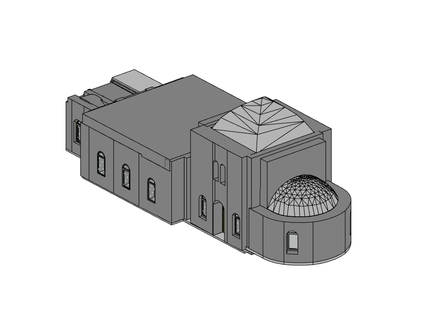
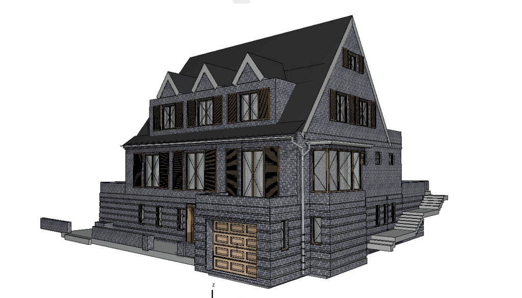
Our BIM Models Examples


Applications of LiDAR Scanning in BIM
LiDAR technology is being used across a wide range of projects to enhance BIM workflows. Below are some of the key applications:
- Renovation Projects
LiDAR and BIM are ideal for restoring aging or historic buildings. By capturing detailed scans of existing structures, teams can create accurate models that respect the building’s original design while enabling modern upgrades. These models help preserve architectural heritage while facilitating compliance with modern building codes and sustainability goals. - Urban Planning
LiDAR-based BIM models are increasingly used for urban planning, allowing city planners to create smart city initiatives, improve infrastructure, and optimize land use. These models provide critical insights for managing urban growth, improving transportation systems, and ensuring environmental sustainability. - Construction Planning
Incorporating LiDAR scans into BIM ensures precise construction planning, minimizing risks and maximizing efficiency during the building process. This is especially important for large-scale projects where precision and effective coordination are vital for success. - Smart Building Design
LiDAR scanning plays a crucial role in the development of smart buildings by providing accurate 3D data for system integration, such as IoT sensors, energy optimization tools, and automated building management systems. These advancements improve occupant comfort while lowering operational expenses. - Historic Preservation
For architects working on historic preservation, LiDAR and BIM provide a way to document and protect cultural heritage while allowing for future restoration. The detailed 3D models ensure that restoration efforts are carried out with precision and respect for the building’s original features.
LiDAR and BIM: Shaping the Future of Architecture
As industries continue to embrace digital transformation, the integration of LiDAR scanning with BIM is becoming increasingly vital. Here’s how this integration is driving the future forward:
- Digital Twins: LiDAR and BIM enable the creation of digital twins, which are virtual replicas of physical assets. These twins are invaluable for monitoring and maintaining building performance, as they provide real-time data for predictive maintenance and operational efficiency.
- Reality Capture: LiDAR enhances reality capture, ensuring that BIM models are based on real-world conditions rather than theoretical designs. This capability is particularly valuable for renovation and retrofit projects where accurate as-built data is critical.
- Smart Cities: By combining LiDAR and BIM, cities can develop smarter, more efficient urban environments that improve quality of life for residents. These technologies enable better resource management, sustainable urban growth, and more effective disaster planning and recovery.
- Environmental Sustainability: LiDAR-powered BIM workflows advance sustainability by optimizing resource utilization and cutting down on waste. Precise data empowers teams to make well-informed choices that adhere to environmental standards and objectives.
Real-World Examples of LiDAR in BIM Workflows
While specific project details may vary, the following examples illustrate how LiDAR and BIM are being used in real-world scenarios:
- Modernizing Commercial Spaces
LiDAR scans of retail and office buildings provide accurate data for remodeling and modernization. These scans help designers create layouts that maximize functionality and align with modern aesthetic trends. - Infrastructure Upgrades
Bridges, highways, and railways benefit from LiDAR-based BIM workflows for maintenance and expansion projects. The detailed models allow engineers to assess structural integrity, plan upgrades, and ensure long-term safety. - Residential Developments
LiDAR helps optimize residential building designs by accurately capturing site conditions. This ensures that homes are built to exact specifications, minimizing construction delays and costs. - Historic Building Preservation
Architects and conservationists use LiDAR and BIM to document historic landmarks with unparalleled detail. These models serve as a blueprint for restoration efforts, ensuring that every element of the building is preserved for future generations. - Disaster Recovery
LiDAR-based BIM workflows are invaluable for assessing damage and planning reconstruction after natural disasters. These technologies provide the data needed to rebuild efficiently and resiliently.
Conclusion
LiDAR scanning and BIM modeling are at the forefront of innovation in architecture, construction, and urban planning. By combining the precision of laser scanning with the versatility of BIM, professionals can achieve unprecedented levels of accuracy, efficiency, and collaboration. Whether you’re planning a new construction project, renovating a historic building, or designing a smart city, LiDAR and BIM are the tools you need to succeed. ScanM2.com offers advanced LiDAR scanning services tailored for BIM integration. Contact us today to learn how we can support your next project with cutting-edge technology and expertise.
Services
- High-Quality Scan to BIM in Los Angeles
- Professional Scan to BIM in Illinois
- Professional Scan to BIM Services in Houston
- Professional Scan to BIM in Florida
- Professional Scan to BIM in Dallas
- Professional Scan to BIM Services in Chicago
- Professional BIM in Washington
- Professional BIM Services in Tampa
- Expert BIM Services in St Louis
- Professional BIM Services in Seattle
- BIM Services in San Francisco
- BIM Services in Portland
- Professional BIM Services in Phoenix
- Professional BIM Services in Orlando
- High-Quality BIM Services in Omaha
- BIM Services in NYC for Architects, Designers, and Builders
- BIM Services in Nashville
- Leading Minnesota BIM Services
- BIM Services in Minneapolis
- BIM Services in Milwaukee
- BIM services in Miami
- BIM Services in Massachusetts
- BIM Services in Los Angeles
- BIM Services in Las Vegas
- BIM Services in Jersey City
- Innovative BIM Services in Irvine
- BIM Services in Connecticut
- BIM Services in Illinois
- BIM Services in Florida
- BIM services in Dallas
- BIM Services in Colorado
- BIM Services in Chicago
- BIM Services in California
- BIM Services in Boston
- BIM Services in Austin
- BIM Services in Atlanta
- BIM Services in San Diego
- BIM Services in San Antonio
- BIM Services in Denver

Clash Detection in Revit: Enhancing Accuracy in 3D Laser Scanning and BIM Modeling
07.07.2025
How integrating as-built documentation using advanced 3D scanning and laser scanning technology can revolutionize your real estate marketing strategy. Learn the benefits for agents and ...

Why 3D Scanning + BIM = Better Projects, Lower Costs, Less Stress
11.04.2025
Developers, architects, and contractors all face the same chronic problems: outdated plans, design clashes, change orders, and construction delays. Most of these issues stem from ...

3D Scanning and BIM Integration: Revolutionizing Smart Building Design
21.01.2025
Discover how 3D scanning and BIM integration shape smarter, more sustainable buildings with advanced laser scanning and design tools.

How Contractors Use 3D Scanning to Minimize Budget Overruns
20.12.2024
Discover how 3D scanning technology revolutionizes modern construction by improving accuracy, planning, and reducing budget overruns.