3D Laser Scanning, LOD 500 Modeling, and 3D Tour Creation for a Timber Frame House in Warwick, New York
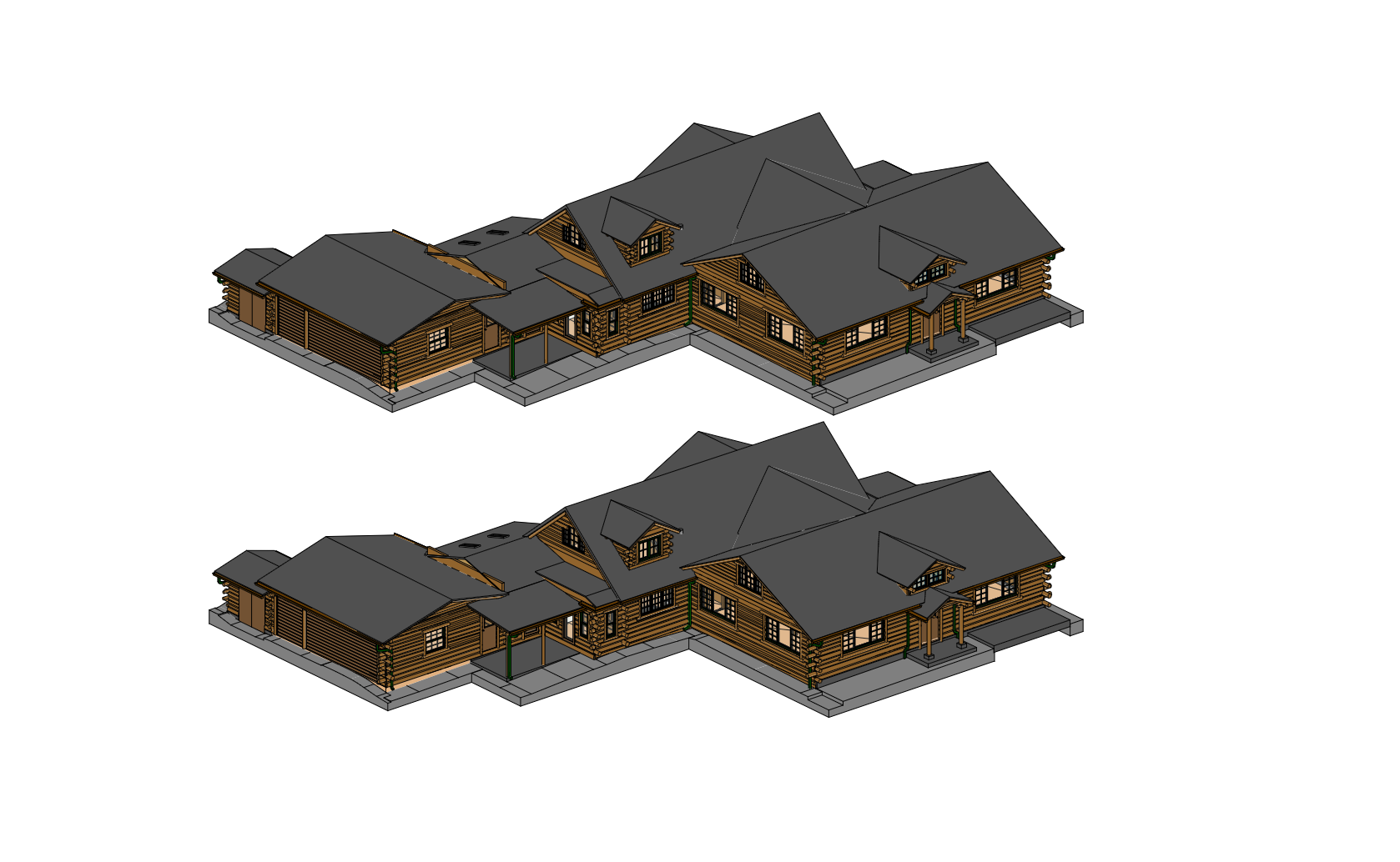
We completed an express 3D laser scanning project for a residential timber frame house in Warwick, New York, with a total area of approximately 5,500 sq ft. The scope included interior and facade scanning, preparation of a highly detailed 3D model, development of 2D documentation, and creation of an interactive 3D tour for future restoration planning. The entire on-site scanning process was completed in just 8 hours, and the final deliverables were provided within a tight project schedule.
This project required much more than standard as-built documentation. The house was built from natural timber beams, which introduced a high level of geometric irregularity and demanded extremely careful modeling of each structural element. In addition, the client required a highly detailed model suitable for restoration planning, including the representation of cracks, deformations, damaged plaster, and other existing conditions.
Project Overview

Project type: 3D laser scanning, as-built documentation, LOD 500 modeling, and 3D tour creation
Location: Warwick, New York
Area: Approximately 5,500 sq ft
Scope: Interior scanning, facade scanning, colorized point cloud capture, 3D modeling, 2D drawing development, and interactive 3D tour preparation
Objective: Deliver a complete digital package for accurate restoration planning within a limited timeframe
Key requirement: Exceptionally detailed representation of geometry, materials, and visible damage conditions at LOD 500
Client’s Request
The client needed a reliable digital representation of the house for future restoration works. The required output was not limited to standard floor plans or a basic model. The architectural team needed a complete dataset that would allow them to analyze the building in detail, identify damaged elements, and prepare restoration decisions with confidence.
The requested deliverables included:
- complete point cloud data;
- accurate 2D floor plans and documentation;
- a detailed 3D model at LOD 500;
- an interactive 3D tour based on colorized scan data.
Why This Project Was Technically Demanding
Natural timber structure
The house was constructed from natural timber beams, and this significantly increased the modeling complexity. Unlike modern standardized materials, timber elements often contain natural deviations, uneven geometry, and visible aging. As a result, each major beam had to be approached individually rather than interpreted as a simplified generic element.
High LOD requirement
The client required an LOD 500 model, which is a much higher level of detail than is needed for typical residential documentation. This level is especially relevant for restoration, preservation, and highly controlled renovation workflows, where the model must closely reflect real existing conditions.
Damage mapping and condition visibility
Another important requirement was the clear representation of cracks, deformations, and damaged building elements. The model needed to show structural and finish-related issues both inside and outside the house, including plaster cracks and deformed timber parts. A stone fireplace also had to be recreated with a very high level of geometric fidelity.
Tight deadline
Although the level of detail was exceptionally high, the project still had to be delivered within a compressed timeframe. The speed of data capture and the efficiency of the post-processing workflow were critical to meeting the client’s schedule.
Technology and Data Capture Approach
To complete the project, we used high-precision FARO 3D laser scanning with color capture. This allowed us to collect both accurate geometric information and colorized visual data during the same fieldwork session. The colorized point cloud played an especially important role in this case because it improved the interpretation of damage, surface conditions, and material transitions while also serving as the basis for the interactive 3D tour.
The choice of laser scanning made it possible to:
- rapidly capture a large and geometrically complex building;
- reduce the need for repeated site visits;
- provide precise geometry for detailed modeling;
- support both technical documentation and visual analysis from one dataset.
Workflow and Project Execution
Day 1 — On-site scanning
The field team completed interior and exterior scanning of the house in approximately 8 hours. The work included colorized data capture to support not only the modeling process but also the future creation of the 3D tour. Despite the large size of the property and the complexity of its geometry, the survey was completed efficiently within a single working day.
Days 1–2 — Point cloud registration and cleanup
After fieldwork, the scan data was registered, aligned, and cleaned. At this stage, we prepared a coordinated point cloud suitable for detailed modeling and drawing extraction. Accuracy at this step was essential because the entire project depended on correctly interpreting complex timber geometry and existing damage conditions.
Days 3–5 — LOD 500 modeling
The main production phase involved developing a highly detailed 3D model in Revit at LOD 500. This included:
- individual modeling of timber beams;
- representation of cracks and deformations;
- detailed modeling of plaster damage;
- reconstruction of the stone fireplace with stone-by-stone precision.
This part of the project was especially demanding because the team had to balance modeling precision with delivery speed, while still preserving the real-world characteristics of the building.
Days 5–6 — 2D drawing development
In parallel with the model completion stage, we prepared accurate 2D floor plans and supporting documentation in DWG and PDF formats. These drawings were derived directly from the processed scan data and model geometry, ensuring consistency across all deliverables.
Day 6 — Interactive 3D tour creation
Using the colorized scan data, we created an interactive 3D tour of the house. This gave the architectural bureau a practical visual tool for remote inspection and planning, allowing the team to review spaces, material conditions, and damaged zones without returning to the site.
Day 7 and final delivery
The final stage included quality control, verification of the required level of detail, and preparation of the full project package for handover. The result was a complete digital dataset for restoration planning and technical coordination.
Deliverables

The client received a full set of project deliverables, including:
- complete point cloud in RCP and RCS formats;
- accurate 2D documentation in DWG and PDF formats;
- 3D model in RVT and DWG formats at LOD 500;
- interactive 3D tour of the house.
Result for the Client
This project gave the client and architectural team a reliable and highly detailed basis for restoration planning. Instead of relying on fragmented manual measurements or repeated site inspections, they received a precise digital record of the building’s actual condition.
The project created value in several ways:
- reduced time spent on site;
- minimized the need for repeated field visits;
- improved visibility of damaged and deformed elements;
- supported accurate restoration planning;
- lowered the risk of design and construction errors during future works.
Most importantly, the LOD 500 model made it possible to identify timber elements requiring replacement or repair with a high degree of confidence, which is essential in restoration-oriented projects involving irregular natural materials.
Conclusion
This case shows how ScanM2 approaches technically demanding residential documentation projects where speed, accuracy, and detail are equally important. For this timber frame house in Warwick, New York, our team combined precise laser scanning, colorized data capture, advanced LOD 500 modeling, and 3D tour creation into one integrated workflow.
The result was not just a set of drawings, but a complete digital foundation for informed restoration decisions