How Point Clouds Are Used in Architecture

Point clouds have become one of the most valuable data sources in modern architectural practice. In projects involving existing buildings, renovation, adaptive reuse, restoration, or complex fit-out, architects need accurate information about real site conditions before design begins. A point cloud provides that foundation.
In architecture, a point cloud is a dense digital representation of a building, space, façade, or site captured through 3D laser scanning or other reality-capture methods. These datasets record the actual geometry of walls, slabs, ceilings, structural elements, openings, and visible building systems. Once processed, they can be used for documentation, design coordination, modeling, and decision-making across the full project lifecycle.
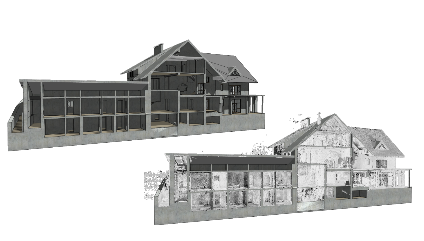
Scan-to-BIM converts point cloud data captured through 3D laser scanning into accurate BIM models that reflect real site conditions. For architects, this workflow provides a dependable foundation for renovation, adaptive reuse, reconstruction, and coordination in existing buildings. In many cases, the resulting data also supports the production of as-built drawings and other existing-condition documentation.
What Is a Point Cloud in Architecture
A point cloud in architecture is a spatial dataset made up of millions of measured points. Each point has coordinates in 3D space, and together these points form a highly detailed digital record of the physical environment. Instead of relying on assumptions, outdated drawings, or manual measurements, architects can work from the actual geometry of the building.
This is especially important in projects where original drawings are incomplete, inaccurate, or no longer reflect site reality. Existing conditions modeling guidance from Penn State’s BIM Project Execution Planning framework defines this as the development of a 3D model of site or facility conditions using methods such as laser scanning and conventional surveying, so the model can be queried for information during modernization or new construction.
How Point Clouds Are Created for Architectural Projects

The workflow typically starts with 3D laser scanning services, during which millions of spatial points are captured from multiple scan positions across the building or site. This process records the visible geometry of walls, floors, ceilings, structural elements, openings, and other architectural features with a high level of detail.
Once the fieldwork is complete, the collected scans are registered and aligned into a single dataset. At this stage, the point cloud is checked for consistency, cleaned of unnecessary noise, and prepared for further use through point cloud processing. This step is essential because raw scan data must be structured and verified before it can support design, documentation, or modeling tasks.
After registration and processing, the point cloud can be imported into architectural software such as Revit, AutoCAD, Archicad, and similar platforms. There, it becomes a precise digital representation of the existing site, allowing architects to work with actual geometry rather than assumptions or outdated drawings.
In practical terms, this transforms the point cloud into a measurable foundation for documentation, coordination, design development, and Scan-to-BIM workflows. Instead of serving as a simple visual reference, it becomes a reliable source of spatial information that supports accurate architectural decisions from the earliest project stages.
How Architects Use Point Clouds in Real Projects
Architects use point clouds in several core scenarios, especially where precision and site awareness are critical.
Existing Conditions Documentation

One of the most common applications is documenting a building exactly as it exists. This includes floor plans, reflected ceiling plans, elevations, sections, façade surveys, and detailed records of interior geometry. For renovation and retrofit work, this step is essential because the design team needs reliable dimensions before making planning decisions.
Point clouds help architects document irregular geometry, sloped floors, non-standard structural grids, settlement, façade deformation, and undocumented modifications that may not appear in legacy drawings.
Renovation and Adaptive Reuse

Point clouds are especially valuable in renovation projects because existing buildings rarely correspond exactly to their archived drawings. Before design work starts, architects need a clear understanding of actual wall locations, slab edges, beam depths, service zones, and available clearances.
A point cloud provides this information by capturing the building as it truly exists, not as it was originally designed. This creates a dependable basis for renovation, reconstruction, and adaptive reuse, where accurate existing-condition data is essential for reducing clashes, avoiding rework, and improving coordination between disciplines.
For architectural teams, this means greater confidence in early design decisions and a more reliable path from survey to implementation.
Heritage and Restoration Projects
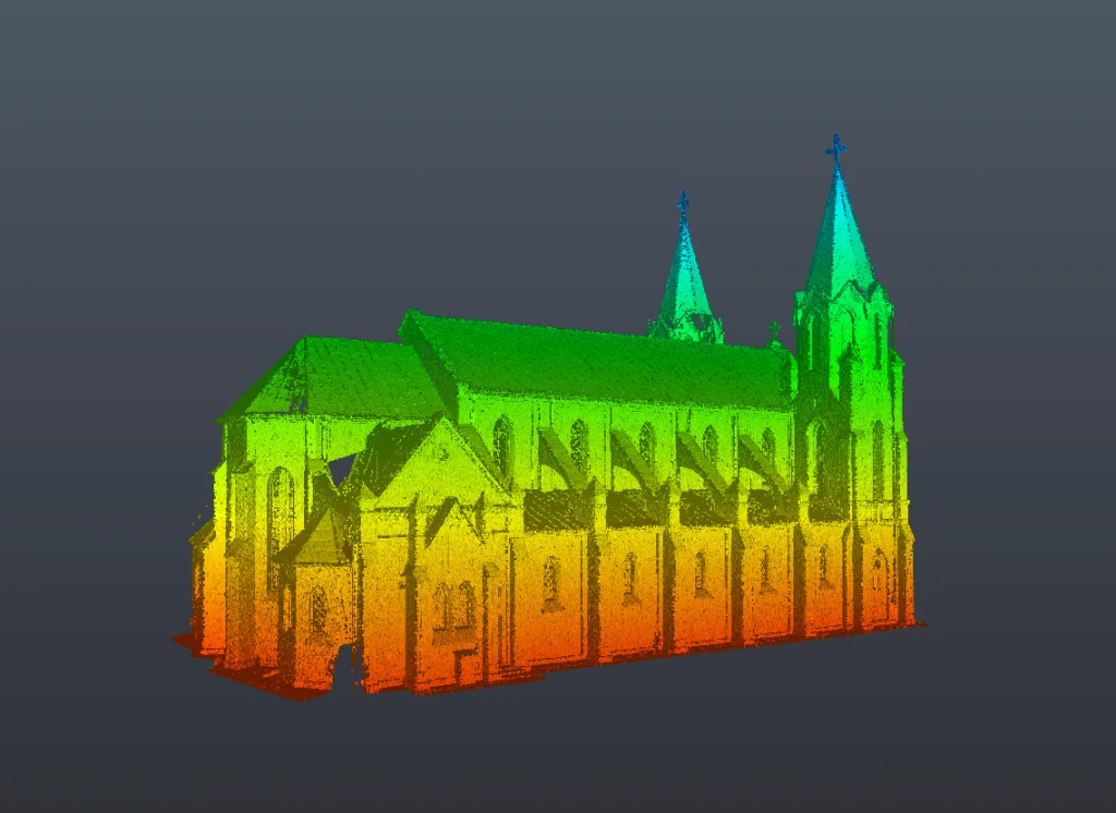
Historic buildings require careful capture of complex geometry, decorative surfaces, vaults, columns, façades, and irregular structural behavior. Manual measurement in these conditions is slow and often incomplete. Point clouds allow architects to preserve geometric detail and create accurate digital references for restoration, conservation, and intervention planning.
Scan-to-BIM and CAD Production
A point cloud is often the starting point for 2D drawings and BIM models. Architects and modeling teams use it to create floor plans, elevations, sections, façade drawings, and intelligent building models with the required level of detail.
This workflow is especially useful when a project needs:
- as-built drawings,
- BIM for existing conditions,
- design coordination before reconstruction,
- tenant fit-out planning,
- MEP routing inside existing buildings,
- accurate base models for consultants.
Comparative Table: Traditional Measurement vs Point Cloud Workflow in Architecture
| Criterion | Traditional manual survey | Point cloud workflow |
|---|---|---|
| Data capture speed | Slower for complex buildings | Faster site capture for large or detailed spaces |
| Geometry coverage | Selective measurements only | Dense capture of visible geometry |
| Complex shapes | Hard to document consistently | Better for irregular and non-standard forms |
| Renovation readiness | Depends heavily on survey scope | Strong base for renovation and adaptive reuse |
| Re-checking dimensions | Often requires return visits | Many dimensions can be verified from the dataset |
| BIM/CAD integration | Requires more reinterpretation | Supports direct modeling and documentation workflows |
| Collaboration | Usually drawing-based | Easier to share across design and technical teams |
| Risk of missed conditions | Higher | Lower, when scanning scope is planned correctly |
Why Point Clouds Matter for Architectural Quality
Architectural design quality depends on the quality of source information. If the team starts with incomplete measurements or outdated plans, errors multiply during design, coordination, and construction. This is one reason digital workflows matter so much in the built environment.
A NIST study estimated that inadequate interoperability in the U.S. capital facilities industry cost $15.8 billion annually, highlighting how fragmented information and disconnected systems create major efficiency losses. While point clouds alone do not solve all interoperability issues, they significantly improve the accuracy and reliability of existing-condition data entering design workflows.
For architects, this translates into practical benefits:
- better confidence in spatial decisions,
- fewer assumptions during concept design,
- stronger coordination with engineers,
- reduced need for repeated site checks,
- more dependable as-built documentation,
- a stronger foundation for BIM-based delivery.
Point Clouds in Design Development
Once imported into the design environment, point cloud data helps architects test interventions against real geometry. Instead of designing against an approximate base, the team works against the actual site.
This is especially useful for:
- interior redesign and fit-out,
- façade remodeling,
- structural alterations,
- extension design,
- MEP integration,
- accessibility upgrades,
- space planning in constrained buildings.
In these scenarios, the point cloud helps reveal where new elements may conflict with existing conditions. It also improves communication between architects, engineers, survey teams, and contractors because all parties can reference the same measured environment.
Challenges of Working with Point Cloud Data
Although point clouds provide significant value for architectural workflows, they still require proper hanAlthough point clouds provide significant value for architectural workflows, they still require proper handling before they can support design and documentation tasks. Raw scan data is not a finished architectural product. It must be registered, checked, cleaned, and interpreted by specialists who understand both spatial geometry and project requirements.
Common challenges include:
- large file sizes,
- visual noise,
- reflective or transparent surfaces,
- incomplete visibility in crowded areas,
- the need for correct scan planning,
- the gap between captured geometry and the modeling logic required for architectural deliverables.
In many projects, additional processing is needed to remove temporary objects, reduce noise, verify alignment, and prepare the dataset for CAD or BIM use. For that reason, point cloud processing services are just as important as the scanning itself.
Without this stage, even a high-quality scan may be difficult to use efficiently in architectural workflows. Properly processed data is what turns raw capture into a reliable basis for documentation, modeling, coordination, and design development.
From Point Cloud to Architectural Deliverables
For architectural teams, the real value of a point cloud lies in the deliverables it supports. Depending on the project, this may include:
- as-built floor plans,
- sections and elevations,
- reflected ceiling plans,
- façade drawings,
- area verification,
- existing conditions BIM models,
- coordination models for renovation,
- digital bases for design development.
This transition from raw scan data to practical architectural documentation is what makes point clouds so powerful. They are not just technical survey files. They are a bridge between physical reality and architectural decision-making.
Why Point Clouds Are Now Essential in Architecture
Architecture increasingly depends on reliable data from the real world, especially as more projects involve redevelopment, modernization, and working within existing constraints rather than designing from empty sites. In that context, point clouds are no longer optional on many project types. They are a core information layer.
They help architects understand the real building, model existing conditions more accurately, coordinate interventions more effectively, and reduce design risks before construction begins. In a market where precision, speed, and coordination directly affect project outcomes, point cloud workflows give architecture teams a major advantage.
Conclusion
Point clouds are used in architecture to capture real site conditions and convert them into usable design intelligence. They support measured documentation, renovation planning, restoration, Scan-to-BIM workflows, and more accurate architectural modeling. For projects involving existing buildings, they provide the clarity that architects need to design with confidence.
If the goal is to reduce uncertainty and build from reality rather than assumption, point cloud data is one of the most effective tools available in contemporary architectural practice.
FAQ
What is a point cloud in architecture?
A point cloud is a dense 3D dataset captured through laser scanning or reality capture that represents the actual geometry of a building or space.
How are point clouds used by architects?
Architects use point clouds for existing conditions documentation, renovation planning, as-built drawings, Scan-to-BIM workflows, and coordination with engineering teams.
Can a point cloud be converted into a BIM model?
Yes. Point clouds are commonly used as the base for BIM modeling, especially in renovation, retrofit, and adaptive reuse projects.
Are point clouds useful for historic buildings?
Yes. They are especially valuable for buildings with irregular geometry, decorative features, and complex surfaces that are difficult to document manually.
What is the main advantage of using point clouds in architecture?
The main advantage is accurate understanding of real site conditions, which improves design quality and reduces errors.