LiDAR Scanning Services for Accurate Spatial Data Capture
LiDAR scanning is used when a project requires reliable spatial information based on real conditions rather than assumptions, outdated drawings, or incomplete records. It helps capture measurable geometry across buildings, sites, technical zones, and external project environments where accurate digital reference is essential.
Our LiDAR services support:
spatial data capture for buildings and sites
digital reference creation for project planning
measurable geometry for technical review
mapping-related project workflows
existing condition documentation
prepared data for engineering and coordination use
This approach helps teams work with more accurate site information and creates a stronger basis for documentation, analysis, and digital project development.
LiDAR Mapping and Site Documentation Workflows
LiDAR mapping services are especially useful when projects require structured spatial information for survey, documentation, planning, or review. Instead of relying only on fragmented field notes or partial geometry references, LiDAR data helps create a clearer digital picture of the site or object.
Typical LiDAR mapping workflows may support:
site documentation
digital terrain and surface reference
project area review
mapping for planning and coordination
measurable data collection for existing conditions
structured geometry for further project use
This type of workflow is relevant for buildings, external sites, technical facilities, land-related project areas, and other environments where measured data improves project accuracy and decision-making.
What LiDAR Services May Include
The exact scope depends on project goals, site conditions, and the required outputs. LiDAR services may include:
site scanning
spatial data capture
LiDAR mapping support
measured geometry collection
point cloud generation
data preparation for project use
organized outputs for documentation and coordination
processed datasets for downstream engineering workflows
Depending on the project, LiDAR data can be used for documentation, digital review, planning, survey support, and further model-based development.
LiDAR Deliverables and Project Use
LiDAR scope What is included Typical use Site scanning Spatial geometry capture from field conditions Survey, mapping, digital reference LiDAR mapping Structured spatial data for land and project workflows Planning, site review, documentation Data processing Organized LiDAR datasets and cleaned outputs Coordination, downstream modeling, analysis Point cloud generation Measured 3D reference data Scan-based workflows, documentation Project-ready outputs Prepared data for further engineering use BIM, as-built, coordination, planning
When LiDAR Services Are Required
LiDAR services are typically required when a project needs measurable site or object geometry for planning, review, documentation, or downstream project development.
Typical situations include:
when accurate spatial data is needed for existing conditions
when project teams require mapping-based digital reference
when buildings or sites must be documented before development begins
when measurable geometry is needed for planning and coordination
when raw scan data must be prepared for further use
when field-based information must support technical workflows
when project documentation depends on verified site conditions
In such cases, LiDAR helps provide more dependable data than fragmented manual reference or incomplete legacy information.
LiDAR for Existing Conditions, Mapping, and Downstream Project Workflows
LiDAR is especially useful for projects where measured conditions must be documented, mapped, and prepared for further technical use. This includes existing building work, site-based review, external areas, technical environments, and project conditions where accurate field geometry is needed before additional engineering steps begin.
LiDAR-based workflows may support:
documentation of existing conditions
mapping of project areas
preparation of digital site reference
organization of measured geometry for engineering use
support for downstream project coordination
more structured digital inputs for technical teams
Depending on project goals, LiDAR data may also support point cloud processing before further modeling or documentation begins. In broader field-data workflows, it may connect with 3D laser scanning and later support scan to BIM development where measured geometry is turned into usable digital models. For projects that require coordinated model environments, LiDAR-based reference may also contribute to BIM modeling workflows and updated as-built documentation .
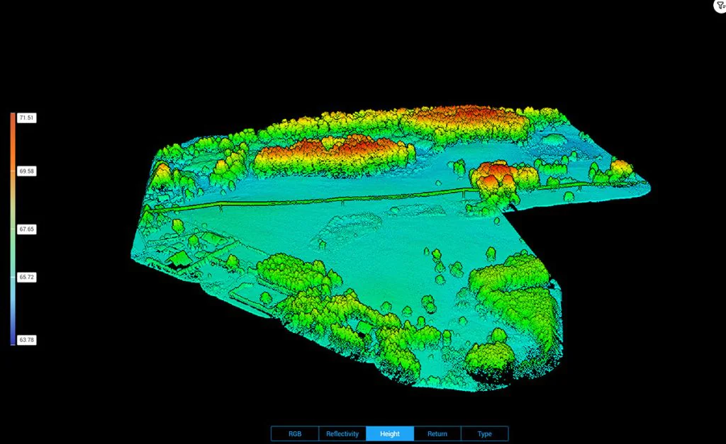
Typical LiDAR Project Types
Examples of LiDAR-based scanning, mapping, and spatial data workflows for buildings, sites, and project documentation.
Our LiDAR Scanning Results
×
❮
❯
Why Choose LiDAR Services in UAE
Companies use LiDAR services when they need accurate spatial information for planning, documentation, and technical workflows that depend on real field conditions.
Key advantages include:
accurate spatial data capture
better digital reference for planning and review
support for mapping and site documentation
usable data for downstream engineering workflows
stronger inputs for scan-based development
improved readiness for coordination and model-based processes
For projects involving existing conditions, external areas, technical spaces, and survey-related documentation, LiDAR creates a more reliable data foundation for engineering and project delivery.
Need LiDAR Services in UAE?
ScanM2 provides LiDAR services in UAE for scanning, mapping, and data processing workflows that require accurate spatial information for documentation, coordination, and project development. We support projects where measured geometry must be captured, organized, and prepared for further technical use.
FAQ
LiDAR services involve the capture and preparation of spatial data using laser-based measurement workflows. They are used for scanning, mapping, digital documentation, and project development where accurate geometry is required.
What is included in LiDAR scanning services?
LiDAR scanning services may include site scanning, spatial data capture, point cloud generation, mapping support, and preparation of measured data for further engineering or documentation use.
Do you provide LiDAR mapping services?
Yes. LiDAR mapping services can support site review, planning, project documentation, and digital spatial reference workflows depending on project scope and required outputs.
Can LiDAR data be processed for project workflows?
Yes. LiDAR data can be organized, cleaned, and prepared for downstream coordination, modeling, documentation, and analysis workflows depending on project needs.
Can LiDAR support BIM and documentation workflows?
Yes. Depending on the project, LiDAR data can support point cloud-based development, scan to BIM workflows, model-based coordination, and documentation updates based on verified site conditions.