

Point Cloud Scanning Services for Buildings and Structures in UAE
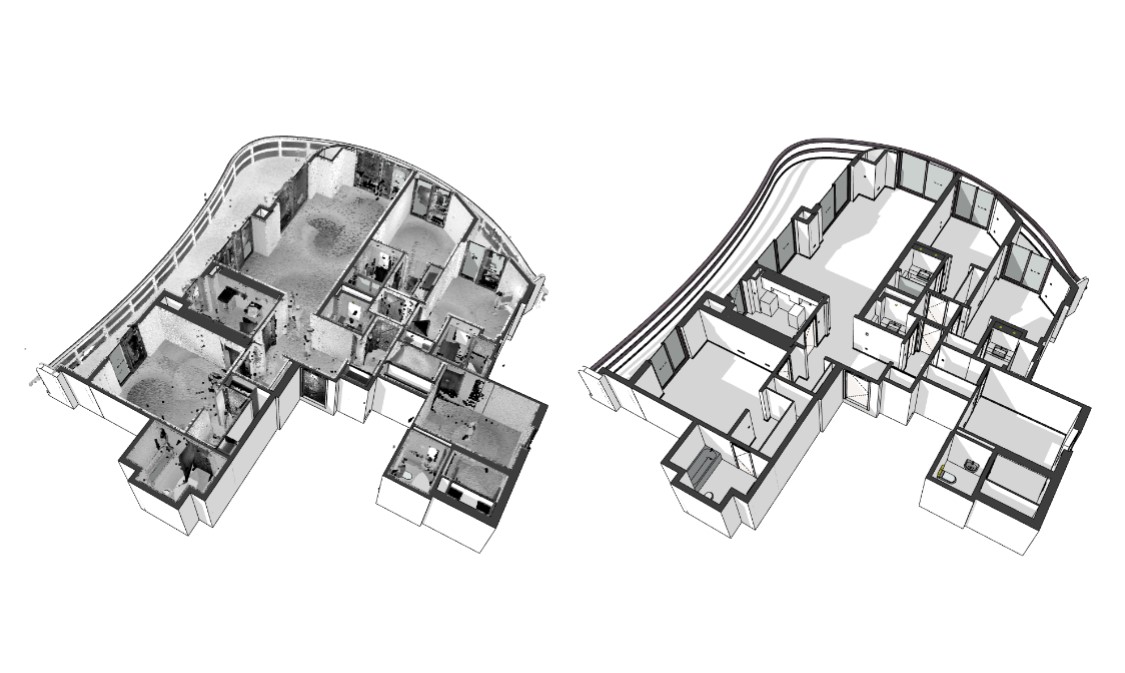
Construction projects in the UAE increasingly rely on measurable, verifiable spatial data rather than assumptions based on outdated drawings. Point cloud scanning services provide a precise digital record of existing conditions, enabling engineers and designers to work with real geometry instead of approximations.
ScanM2 delivers laser-based point cloud scanning focused on engineering usability. Our datasets are created to support construction coordination, BIM workflows, and accurate 3D modeling — not for visualization or marketing purposes.
Contact Us Now for a Free Consultation!
Why Point Cloud Data Matters in UAE Projects
High-rise construction, dense MEP systems, and phased developments are standard in the UAE. In such environments, even small geometric deviations can result in costly clashes and redesigns.
Point cloud surveys allow project teams to:
- capture actual building geometry before design decisions are made;
- verify as-built conditions during construction;
- reduce uncertainty in renovation and retrofit projects;
- provide a single source of spatial truth for all stakeholders.
This makes point cloud scanning a foundational step rather than an optional add-on.
Laser Point Cloud Scanning in UAE: From Site to Dataset
3D Point Cloud Scanning on Site
We perform laser point cloud scanning using terrestrial scanners configured for architectural and engineering environments. Scan positions and density are planned based on required accuracy, line-of-sight constraints, and downstream use.
Registration and Control
All scans are registered into a unified coordinate system. Control checks are performed to ensure spatial consistency across the dataset.
Point Cloud Processing
Processed datasets include:
- noise filtering and cleanup;
- classification of structural and architectural elements;
- preparation for modeling and analysis.
The result is a clean, engineering-ready point cloud, not raw scan output.
Point Cloud Modeling Services
Point cloud modeling services focus on transforming processed scan data into structured 3D representations suitable for engineering analysis and coordination. Unlike visualization models, point cloud–based models are created with strict reference to measured geometry and validated datasets.
ScanM2 develops point cloud models that support:
- dimensional verification and spatial analysis;
- preparation for point cloud to BIM workflows;
- coordination of architectural and structural elements;
- generation of reliable inputs for design and construction planning.
Model complexity and level of detail are defined based on project objectives, ensuring that modeling efforts remain aligned with practical engineering requirements.
Point Cloud Processing and Conversion Workflows
Point cloud data becomes valuable only when it is usable. ScanM2 provides structured workflows for:
- point cloud processing for CAD and BIM environments;
- point cloud to BIM conversion for coordinated modeling;
- point cloud to Revit for architectural and MEP design;
- point cloud data to 3D model development for engineering analysis.
These workflows ensure that captured data directly supports project decisions.
Examples of Point Cloud Applications
Point Cloud Applications in Real Projects UAE


Point Cloud to BIM Services
Point cloud scanning delivers accurate spatial data, but its full value is realized only when this data is transformed into structured BIM models. ScanM2 provides point cloud to BIM services that convert laser scan datasets into coordinated models suitable for architectural, structural, and MEP workflows.
Our process focuses on engineering usability rather than visual approximation. Geometry, levels, and reference systems are defined to ensure that BIM models created from point cloud data can be reliably used for coordination, documentation, and construction planning.
Point Cloud to Revit (Scan to BIM Revit)
For projects based on Autodesk environments, we deliver point cloud to Revit conversion using controlled Scan to BIM Revit workflows. Laser scan data is imported, aligned, and modeled using BIM-native parametric elements to maintain accuracy and consistency.
Scan to BIM Revit is commonly applied in:
- renovation and retrofit projects;
- MEP coordination in existing buildings;
- preparation of as-built BIM documentation;
- verification of design models against real conditions.
The resulting Revit models are structured for downstream use, not visualization, and can be exported to RVT, IFC, and DWG formats.
When Point Cloud to BIM Is the Right Choice
Point cloud to BIM services are most effective when:
- existing drawings are outdated or unreliable;
- geometric accuracy directly affects coordination outcomes;
- construction tolerances must be verified before design decisions.
In such cases, scan-based BIM modeling significantly reduces uncertainty and rework compared to manual reconstruction from legacy documentation.
Accuracy, Density, and Deliverables
Our point cloud scanning service is defined by measurable technical parameters.
Typical specifications:
- Accuracy: up to ±2 mm (project-dependent);
- Formats: E57, RCP/RCS, RVT, IFC, DWG;
- Applications: point cloud modeling services, Scan to BIM, coordination models.
Accuracy targets are defined during project setup to align with construction or design requirements.
Point Cloud Building Scan vs Traditional Documentation
| Aspect | Traditional Drawings | Point Cloud Building Scan |
|---|---|---|
| Basis | Assumptions / legacy data | Measured reality |
| Level of detail | Limited | Full geometry |
| Update effort | Manual | Digital |
| BIM readiness | Low | High |
| Coordination reliability | Medium | High |
This is why point cloud building scans are now standard for complex UAE projects.
Industry Context and Digital Construction
The UAE construction sector actively adopts digital workflows to reduce risk and improve efficiency.
- Autodesk reports that reality capture integrated with BIM improves coordination accuracy and reduces rework.
- McKinsey highlights that data-driven construction processes increase productivity on large-scale projects.
Point cloud scanning aligns directly with these objectives by providing reliable spatial data at the earliest stages.
Typical Use Cases Across Project Stages
Point cloud scanning is applied at multiple stages of building and infrastructure projects where reliable spatial data is critical. SCANM2 point cloud services support engineering decisions from early assessment through construction and documentation.
Typical use cases include:
- Commercial and residential buildings — verification of existing conditions, floor layouts, and façade geometry prior to design or renovation.
- Industrial and logistics facilities — capture of complex structural grids, equipment zones, and clearance conditions for layout planning.
- Renovation and adaptive reuse projects — accurate documentation where original drawings are incomplete or no longer reflect reality.
- BIM coordination and as-built documentation — generation of coordinated datasets for clash detection, verification, and record models.
Each point cloud dataset is structured to remain usable throughout the project lifecycle, supporting design validation, coordination, construction planning, and long-term asset management.
FAQ – Point Cloud Scanning Services
What is included in point cloud surveys?
Can point cloud data be used directly for BIM modeling?
Is point cloud scanning suitable for renovation projects?
Do you provide point cloud modeling services?
Request Point Cloud Scanning Services in UAE
If your project requires accurate spatial data for design, coordination, or construction, SCANM2 delivers point cloud scanning services engineered for real-world use.
📩 Contact ScanM2 to discuss point cloud scanning and processing solutions tailored to your project in the UAE.

