How Existing Building Documentation Is Created from Laser Scanning

Accurate existing building documentation is the foundation of renovation, reconstruction, retrofit, and technical upgrade projects. Before architects, engineers, or contractors can move into design and coordination, they need dependable information about the building as it actually exists. In reality, this is often a problem: legacy drawings may be outdated, incomplete, or missing entirely, while manual measurements can leave gaps that later turn into design conflicts and construction errors.
This is why many project teams use 3D Scanning Services For Existing Buildings to capture real site conditions and turn them into usable technical documentation. Laser scanning creates a detailed digital record of the property, allowing specialists to work from measured geometry rather than assumptions. That digital record can then be converted into drawings, models, and coordinated deliverables for further project stages.
Why Existing Building Documentation Matters
Existing building documentation is required whenever a team needs to understand the real geometry, dimensions, and configuration of a property before design or construction begins. Even relatively simple renovation work can be affected by undocumented changes in wall positions, ceiling levels, openings, structural elements, or engineering systems.
It is most commonly needed for:
- renovation and retrofit planning
- design coordination across disciplines
- tender and permit documentation
- verification of actual on-site conditions
Without reliable documentation, the project team is forced to make decisions based on incomplete information. That usually increases the risk of rework, site clarification requests, change orders, and delays during later phases.
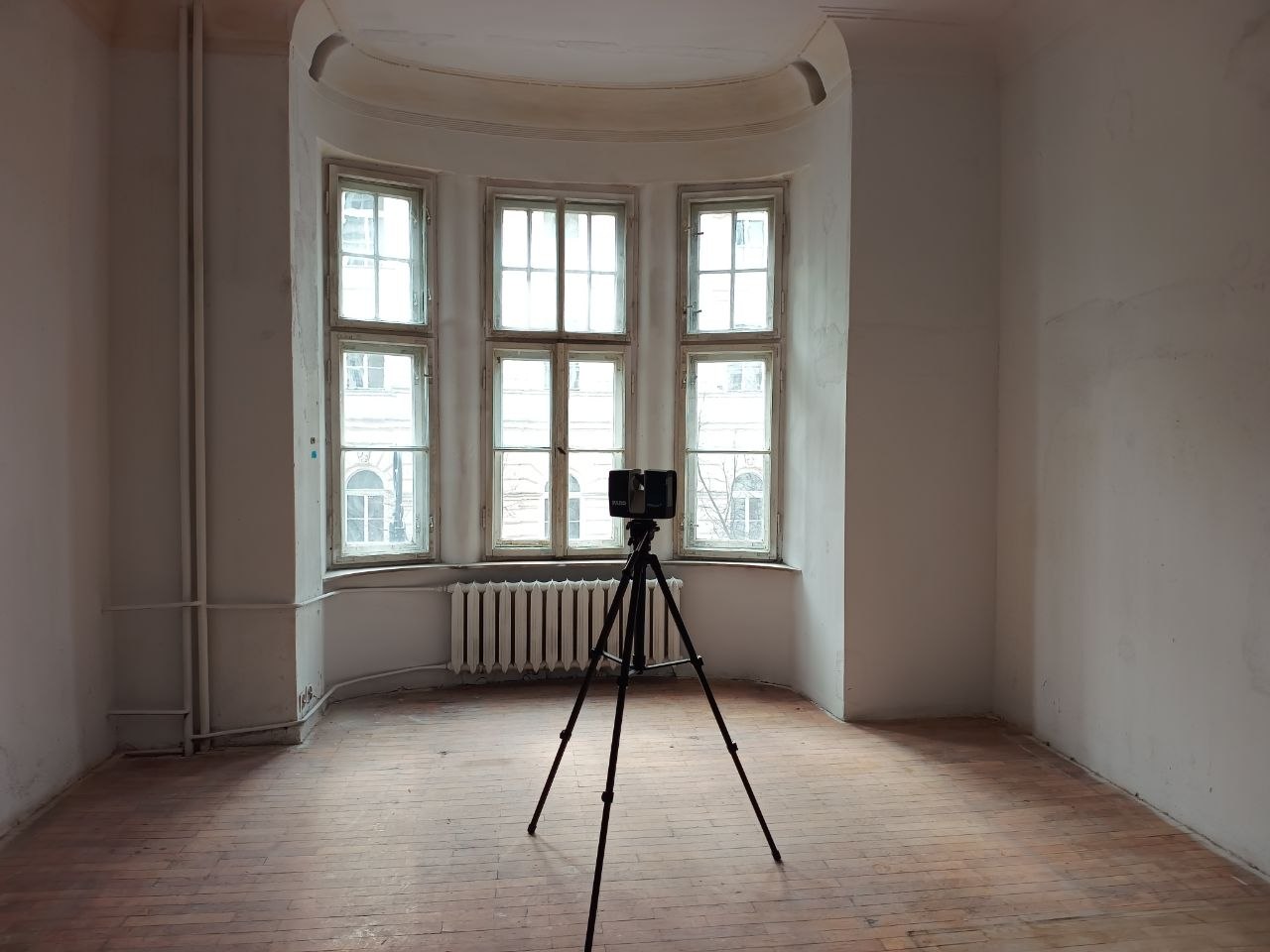
How Laser Scanning Captures Existing Conditions
The process begins on site with terrestrial laser scanning. The scanner is placed at multiple positions throughout the building so it can capture visible surfaces from different viewpoints. Each scan records millions of measured points in three-dimensional space, creating a highly detailed geometric representation of the property.
Compared with traditional hand measurement, this method allows much broader and more consistent coverage. It is especially effective for larger buildings, irregular spaces, technical rooms, renovation projects, and sites where precision is critical for downstream design work.
Laser scanning typically captures:
- walls, floors, and ceilings
- openings, stairs, and façade elements
- visible structural and MEP geometry
The result is not yet a drawing or a model, but a raw digital dataset that reflects the actual building condition.
Workflow: From Site Capture to Final Documentation

After fieldwork is completed, the scan data passes through several technical stages before it becomes a finished deliverable. The core workflow is usually straightforward, but the quality of each stage affects the final result.
| Stage | Description | Output |
|---|---|---|
| Site scanning | On-site capture from multiple scan positions | Raw scan data |
| Registration | Alignment of scans into one coordinate system | Registered point cloud |
| Review | Quality control, coverage check, geometry verification | Verified site data |
| Drafting / modeling | Conversion into drawings or BIM outputs | Final documentation package |
Once the scans are registered, the project team works with a point cloud — a dense digital representation of the building formed from measured spatial data. This point cloud becomes the basis for extracting dimensions, tracing geometry, producing drawings, or building a BIM model of existing conditions.
How As-Built Drawings Are Created

One of the most common outputs of this workflow is a set of as-built drawings services deliverables. In this stage, specialists interpret the point cloud and trace the actual building geometry in CAD-based software. The goal is to convert raw scan data into clear, structured 2D documentation that architects, engineers, contractors, and owners can use in practice.
These drawings are especially valuable when old plans cannot be trusted or when the building has undergone undocumented changes over time. Because the drawings are based on measured site conditions, they provide a much more reliable basis for renovation and technical planning.
Typical as-built deliverables include:
- floor plans
- sections
- elevations
- reflected ceiling plans
Depending on the scope, the package may also include façade documentation, roof plans, dimensioned layouts, or room-by-room technical drawings.
How BIM Models for Existing Buildings Are Developed

In more advanced projects, the point cloud is not used only for 2D drafting. It can also serve as the reference for a digital building model. This is where BIM modeling services for existing buildings become relevant.
A BIM model transforms measured site data into a structured digital representation of the property. Instead of viewing the building only through plans and sections, the project team can work with a coordinated 3D model that reflects actual existing conditions. Depending on the project scope, the model may include architectural elements, structural systems, and selected MEP components.
A BIM model is typically used for:
- renovation design
- multidisciplinary coordination
- clash detection
- digital asset documentation
For projects with multiple stakeholders or more complex design workflows, this approach often provides much greater value than a 2D-only documentation package.
Contact Us Now for a Free Consultation!
Laser Scanning vs Manual Measurement
Manual measurement may still be acceptable for very small and simple spaces, but its limitations become clear on medium-sized, large, or technically complex buildings. Laser scanning provides a much stronger digital base, particularly when the same site data will be reused for drawings, BIM, and coordination.
| Aspect | Manual Measurement | Laser Scanning |
|---|---|---|
| Speed on complex sites | Slower | Faster |
| Coverage | Limited | Broader |
| Accuracy consistency | Less stable | More consistent |
| Reuse for CAD/BIM | Limited | High |
This is why laser scanning is often the preferred option for existing buildings that require dependable documentation and future-ready digital outputs.
What Affects Documentation Quality
Even with good scan technology, final documentation quality still depends on how well the project is executed. The fieldwork must provide sufficient scan coverage, the registration must be stable and accurate, and the required level of detail must be defined from the start. The experience of the production team also matters, because converting point cloud data into useful drawings or models requires technical judgment as well as software skill.
The main factors that affect quality are:
- scan coverage
- registration quality
- required level of detail
- experience of the production team
If these parts are handled correctly, the resulting documentation becomes a strong basis for design, coordination, and construction planning.
Conclusion
Existing building documentation created from laser scanning gives project teams a reliable digital foundation for renovation and design. Instead of relying on assumptions, outdated drawings, or fragmented field notes, specialists can work from measured site data that reflects the true condition of the property.
From on-site capture and point cloud registration to as-built drawings and BIM deliverables, this workflow helps reduce uncertainty and improve coordination across the entire project lifecycle. For buildings where accuracy matters, laser scanning is one of the most efficient ways to create dependable existing conditions documentation.
FAQ
What is existing building documentation?
What is created from laser scanning data?
Are as-built drawings created from point clouds?
When is a BIM model better than 2D drawings?
Is laser scanning better than manual measurement?

How Existing Building Documentation Is Created Using 3D Laser Scanning
23.07.2026
From Reality Capture to Accurate CAD Drawings and BIM Models Accurate Existing Building Documentation is the foundation of every successful renovation, modernization and adaptive reuse ...

BIM Coordination for Data Centers: Preventing Costly Conflicts Before Construction
15.07.2026
Coordinated BIM Models for Mission-Critical Facilities, MEP Systems, and Data Center Expansion Modern data centers are among the most technically demanding building types in the ...

ScanM2 at INTERGEO 2026 in Munich – Meet Us at the World’s Leading Geospatial Technology Exhibition
10.07.2026
This September, ScanM2 will participate as an exhibitor at INTERGEO 2026, the world’s leading trade fair for geodesy, surveying, laser scanning, mapping, BIM, GIS, and ...

Digital Twin vs BIM: What’s the Difference?
30.06.2026
Why Are BIM and Digital Twins Often Confused? The terms Building Information Modeling (BIM) and Digital Twin are frequently used interchangeably. Both involve digital representations ...