What Makes a Point Cloud Ready for BIM Modeling

Many project teams assume that once a building has been scanned, the data is immediately ready for BIM modeling. In reality, the quality of the final BIM model depends heavily on the quality, completeness, and organization of the point cloud itself.
Even highly accurate laser scanning can produce datasets that are difficult to model if coverage is incomplete, scans are poorly registered, or project requirements were not properly defined from the start.
Before BIM modeling begins, the point cloud should be reviewed, validated, and prepared to ensure that it supports the intended project goals.
This is why professional point cloud services play a critical role in successful BIM workflows.
What Is a BIM-Ready Point Cloud?
A BIM-ready point cloud is a point cloud that contains sufficient geometric information, accuracy, coverage, and organization to support efficient BIM model creation.
The goal is not simply to collect a large amount of data. The goal is to collect the right data.
A BIM-ready point cloud should provide:
- complete geometric coverage;
- accurate measurements;
- reliable registration;
- minimal data gaps;
- organized coordinate systems;
- clear visibility of required building elements.
Without these characteristics, BIM modelers may need to make assumptions, reducing overall model reliability.
Complete Coverage Is More Important Than Point Count

Many people focus on the number of points captured during scanning. However, point density alone does not guarantee a successful BIM project.
What matters more is whether all required elements have been properly captured.
Typical elements that must be visible include:
- walls;
- floors;
- ceilings;
- structural systems;
- doors and windows;
- equipment;
- exposed MEP systems;
- façade elements.
Missing areas often create modeling challenges that cannot be solved later in the office.
Even a highly detailed scan may become difficult to use if critical geometry was never captured on site.
Accurate Registration Creates Reliable Geometry

Individual scans must be registered into a unified coordinate system before modeling begins.
Registration aligns multiple scan positions and creates a single, coherent point cloud.
Poor registration can result in:
- duplicated geometry;
- shifted walls;
- distorted dimensions;
- alignment errors;
- unreliable measurements.
A BIM model is only as accurate as the point cloud used to create it.
This is one of the reasons why quality control is a critical step in every point cloud to BIM services workflow.
Why Noise and Unnecessary Data Should Be Removed
Raw scan data often contains information that is not useful for BIM modeling.
Examples include:
- moving people;
- temporary construction materials;
- vehicles;
- equipment not included in project scope;
- environmental interference.
Point cloud cleaning helps remove unnecessary information and improves modeling efficiency.
A cleaner dataset allows BIM specialists to focus on relevant building geometry rather than processing excessive amounts of unwanted data.
Defining BIM Requirements Before Modeling Starts
Not every project requires the same level of BIM detail.
Before modeling begins, the project team should clearly define:
- project goals;
- required disciplines;
- level of detail;
- accuracy requirements;
- deliverable formats;
- coordination needs.
Typical BIM deliverables may include:
- architectural models;
- structural models;
- MEP models;
- Revit models;
- IFC exports;
- as-built BIM documentation.
Clear requirements help prevent unnecessary modeling work while ensuring that important project information is captured.
Common Problems That Make Point Clouds Difficult to Model
Several issues can significantly reduce modeling efficiency.
Common examples include:
- incomplete scan coverage;
- inaccessible areas;
- poor scan planning;
- weak registration quality;
- missing coordinate control;
- excessive noise;
- unclear project requirements.
These issues often lead to additional modeling time, reduced accuracy, and increased project costs.
Most of them can be avoided through proper planning before scanning begins.
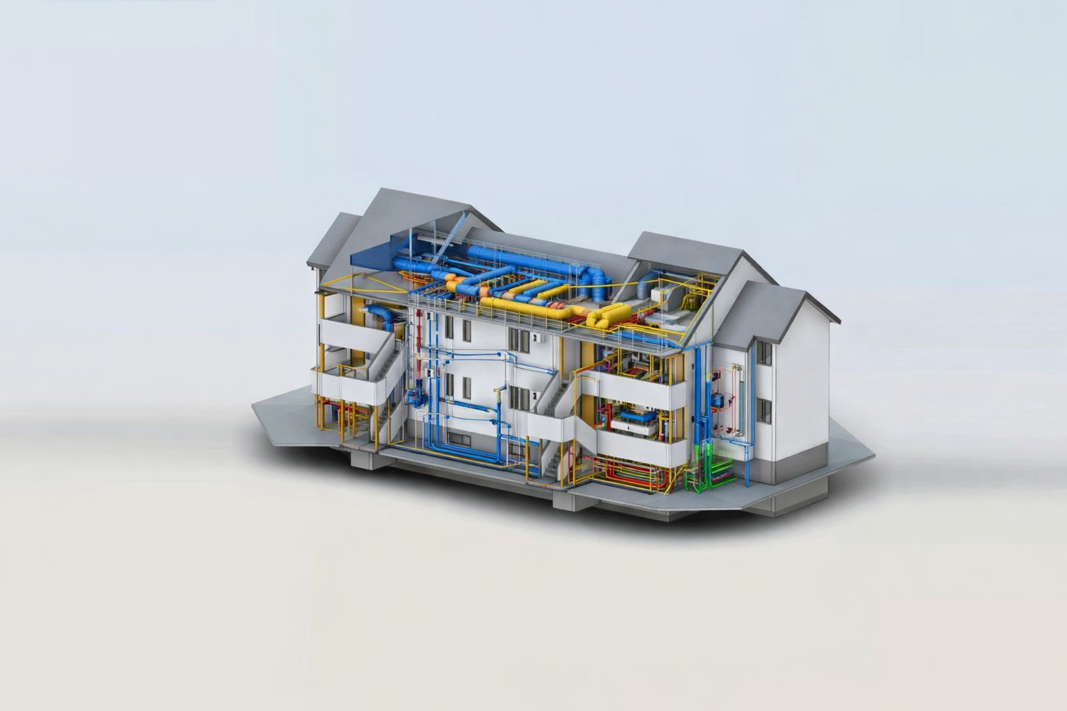
How Point Clouds Support Scan-to-BIM Projects
A point cloud serves as the foundation for the entire BIM workflow.
Once validated and prepared, it allows modelers to accurately recreate:
- building geometry;
- structural systems;
- architectural layouts;
- MEP infrastructure;
- equipment locations;
- existing site conditions.
Professional Scan to BIM services rely on well-prepared point clouds to produce coordinated digital models that support renovation, reconstruction, facility management, and future project development.
From Point Cloud to BIM Model

After preparation and validation, the modeling process can begin.
A typical workflow includes:
| Stage | Output |
|---|---|
| Laser scanning | Raw scan data |
| Registration | Registered point cloud |
| Quality control | Verified point cloud |
| Point cloud processing | Modeling-ready dataset |
| BIM modeling | Revit or IFC model |
| QA/QC review | Coordinated BIM deliverable |
Each stage contributes to the quality and reliability of the final model.
Skipping preparation steps often creates problems later in the project lifecycle.
Why BIM Model Accuracy Starts with Good Scan Data
The accuracy of a BIM model is not determined during modeling alone.
It starts much earlier with project planning, scanning strategy, registration quality, and point cloud preparation.
When scan data is complete, organized, and validated, BIM teams can create models more efficiently and with fewer assumptions.
This leads to:
- higher model accuracy;
- fewer coordination issues;
- improved renovation planning;
- reduced rework;
- better project outcomes.
For this reason, successful BIM modeling services always begin with high-quality point cloud data.
Ready to Transform Point Cloud Data into BIM?
ScanM2 provides point cloud processing, BIM modeling, Scan-to-BIM workflows, and digital documentation services for existing buildings, renovation projects, industrial facilities, and infrastructure assets.
Our team helps clients convert laser scan data into accurate Revit and IFC models that support design, coordination, construction, and facility management.
Contact ScanM2 to discuss your point cloud, Scan-to-BIM, or BIM modeling project.
FAQ
What is a BIM-ready point cloud?
Why is point cloud registration important?
Can BIM models be created from any point cloud?
Does a higher point count automatically mean a better BIM model?
What file formats can be used for BIM modeling?
Can ScanM2 process existing point cloud data?

What Architects Should Check Before Ordering a Scan-to-BIM Model
25.05.2026
Why Good Scan-to-BIM Projects Start Before Scanning Many architects approach Scan-to-BIM workflows expecting that laser scanning automatically produces a fully coordinated BIM model ready for ...

When a Point Cloud Should Become CAD and When It Should Become BIM
11.05.2026
Laser scanning technology allows project teams to capture highly accurate information about existing buildings. After scanning is completed, the result is typically a point cloud — ...

What Is Scan to Revit and When Is It Needed
20.04.2026
Working with existing buildings is rarely straightforward. Original drawings may be outdated, incomplete, or missing altogether, while manual site measurements often fail to capture real ...

How Point Clouds Improve HVAC and Electrical BIM Coordination
02.03.2026
HVAC and electrical system coordination becomes significantly more reliable when design teams work from verified field data rather than assumptions. In renovation and retrofit environments, ...