

3D Laser Scanning for Hydroelectric power station
Hydroelectric power stations combine large civil engineering structures with complex mechanical and electrical systems. Turbine halls, generators, penstocks, intake structures, spillways, technical galleries, and auxiliary equipment must operate within tightly coordinated spaces. When a facility undergoes modernization, reconstruction, or equipment replacement, accurate information about its existing geometry becomes essential.
ScanM2 provides 3D Laser Scanning Services for Hydroelectric Power Stations, capturing existing building structures, industrial equipment, piping systems, and accessible infrastructure with high-precision terrestrial laser scanning. The resulting point clouds provide a measured digital foundation for engineering design, plant upgrades, as-built documentation, and BIM modeling.
Contact Us Now for a Free Consultation!
Why Hydroelectric Power Stations Need Accurate 3D Surveys
Hydroelectric facilities often operate for decades while their equipment, auxiliary systems, and building structures undergo successive modifications. Original construction drawings may not reflect the current arrangement of machinery, pipelines, supports, cable routes, or technical spaces.
For engineers planning new installations or reconstruction, even relatively small geometric discrepancies can create problems where equipment interfaces with existing structures. Laser scanning establishes a measurable spatial reference based on the facility’s current visible conditions.
This information is particularly useful when a modernization project must be designed around existing turbines, generators, structural supports, or operational infrastructure.
What We Scan at Hydroelectric Power Stations
The scanning scope depends on the facility layout, site accessibility, and engineering objectives. Individual technical zones can be surveyed independently or combined into a coordinated dataset covering multiple parts of the hydroelectric installation.
Turbine Halls and Generator Areas
Turbine halls contain major equipment, structural elements, access platforms, lifting equipment, and auxiliary systems. Their geometry is important when planning machinery replacement, installation routes, maintenance access, or changes to equipment foundations.
3D laser scanning captures visible equipment envelopes, structural columns, floors, overhead elements, openings, and other accessible features required for engineering coordination.
Penstocks and Pressure Piping
Penstocks and associated pressure piping can involve large diameters, changes in direction, complex connections, and structural supports. Accurate measurements are important when designing modifications or coordinating new components with existing installations.
Laser scanning can document accessible external pipe geometry, bends, flanges, support structures, and surrounding clearances. Internal surfaces require a separate capture approach where access and operating conditions permit.
Intake Structures and Spillways
Intake areas, spillways, gates, channels, and associated concrete structures form an important part of hydroelectric infrastructure. Their existing geometry may need to be documented before repair, reconstruction, or modification.
Survey methods are selected according to visibility, accessibility, environmental conditions, and the required coverage. Terrestrial laser scanning can capture accessible structural surfaces and exposed components, while underwater or otherwise inaccessible areas require other measurement methods.
Technical Galleries and Service Areas
Hydroelectric power stations can contain narrow technical galleries, service corridors, equipment chambers, and utility spaces with limited access. These areas often include densely arranged piping, valves, supports, electrical installations, and mechanical equipment.
Multiple scanning positions help capture visible geometry around obstructions and establish spatial relationships between equipment and the surrounding structure.
Scanning Mechanical Equipment and Complex Piping Systems
Auxiliary mechanical systems can occupy significant space within a hydroelectric facility. Pumps, valves, tanks, compressors, heat exchangers, and associated piping may be installed close to structural elements or other equipment.
Laser scanning helps document the existing arrangement of these systems before replacement, rerouting, or installation of additional equipment. The captured geometry can be used to examine available space, identify potential interferences, and prepare models or drawings for engineering teams.
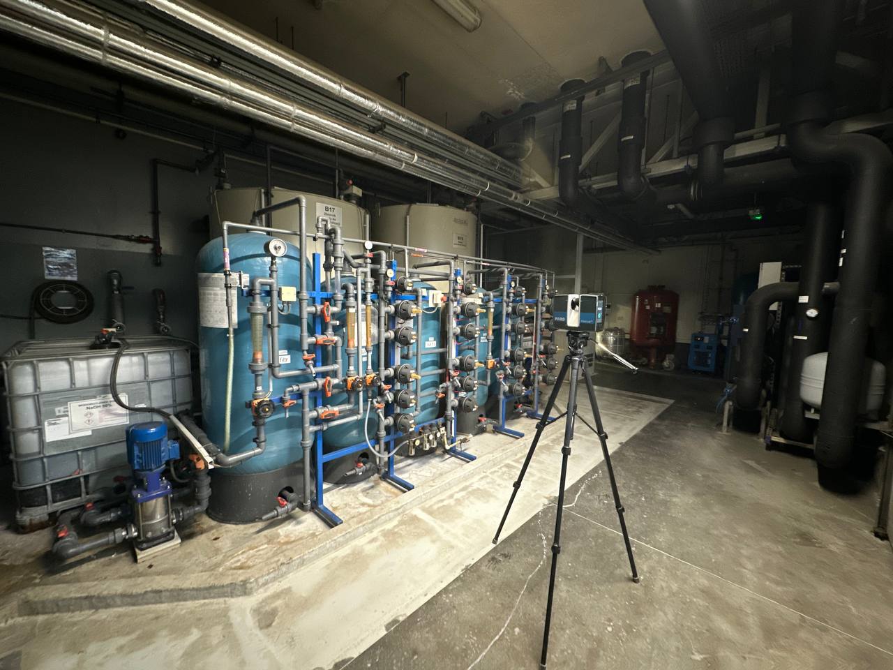
ScanM2 also performs 3D laser scanning in equipment-dense industrial environments. Such surveys demonstrate the practical approach used to capture mechanical installations and piping, although the equipment and photographs shown are not presented as a completed hydroelectric power station project.
3D Laser Scanning for Hydroelectric Plant Modernization
Modernization projects frequently require new equipment to fit within an existing powerhouse or technical building. The available installation space may be constrained by structural columns, floor elevations, overhead systems, foundations, and existing machinery.
A measured point cloud provides engineers with a common geometric reference before detailed design begins. It can support the evaluation of equipment dimensions, installation clearances, pipe routing, access requirements, and the relationship between new components and existing construction.
When a coordinated information model is required, the scan data can support Scan to BIM Services for Hydroelectric Power Stations.
Documenting Equipment Foundations and Structural Interfaces
Equipment replacement is not limited to the machinery itself. Existing foundations, mounting surfaces, support frames, access openings, and nearby structural elements may influence the design and installation process.
3D laser scanning captures visible existing conditions around these interfaces, providing a basis for dimensional assessment and engineering coordination. Where detailed structural assessment, hidden geometry, or material verification is required, scanning must be supplemented by appropriate engineering investigations.
Capturing Large Structures and Small Technical Details
Hydroelectric power stations create a particular measurement challenge: a single project may involve large concrete structures and relatively compact equipment areas requiring much closer observation.
Scanning density, station placement, and survey coverage should therefore be planned around the intended use of the data. A general structural survey does not necessarily require the same capture strategy as detailed equipment coordination.
For example, a powerhouse reconstruction project may require broad structural coverage, while the replacement of a specific auxiliary system may require a focused survey of its connection points and surrounding equipment.
Working Around Operational Hydroelectric Infrastructure
Surveying an operating power station requires coordination with facility personnel and compliance with site access and safety procedures. Restricted areas, moving machinery, high-voltage equipment, wet surfaces, and operational systems can affect where and when scanning is permitted.
The survey plan should account for these restrictions, identify accessible scanning locations, and establish whether specific areas require an approved shutdown or additional access arrangements.
Terrestrial laser scanning is a non-contact measurement method, but it does not remove the need for plant-specific safety planning or authorization.
From Hydroelectric Power Station Scans to a Coordinated Point Cloud
Each scanner position records visible surfaces from a particular location. To create a useful facility dataset, individual scans must be registered and aligned within a consistent spatial reference.
The resulting point cloud can represent multiple connected areas of the power station, including equipment rooms, structural spaces, piping installations, and accessible exterior structures.
Registration, cleaning, organization, and preparation of the captured data can be carried out through our Point Cloud Processing Services for Hydroelectric Power Stations.
What Can Engineers Do with the Scan Data?
Once the survey has been processed, the point cloud can support different engineering workflows depending on the project’s requirements.
- Measure existing equipment locations and accessible clearances
- Review the spatial relationship between machinery and structures
- Plan equipment installation and replacement
- Coordinate piping modifications and new equipment connections
- Prepare existing-condition CAD drawings
- Develop BIM models for modernization and reconstruction
- Document visible structural geometry
- Reduce the need for repeated site measurements during design
From 3D Laser Scanning to As-Built Documentation
Not every hydroelectric modernization project requires a complete BIM model. Some engineering tasks primarily need accurate plans, elevations, sections, equipment layouts, or documentation of existing technical areas.
Scan data can be used to prepare measured drawings that reflect accessible existing conditions. Our As-Built Drawings Services for Hydroelectric Power Stations focus on producing the required 2D documentation from measured survey information.
When a Hydroelectric Power Station Needs a BIM Model
Projects involving several interconnected engineering systems may benefit from a structured 3D model. Building geometry, structural components, major equipment, and selected piping systems can be represented together to support spatial coordination.
Our BIM Modeling Services for Hydroelectric Power Stations can transform the required existing-condition geometry into a coordinated model with content and detail defined by the engineering task.
3D Scanning for Equipment Replacement and Reverse Engineering
Existing mechanical components sometimes need to be modified, replaced, or reproduced when complete original geometry is unavailable. Laser scanning can capture accessible external surfaces and the surrounding interfaces required for subsequent geometric reconstruction.
For projects that require a reconstructed digital model of specific components, our Reverse Engineering Services for Hydroelectric Power Stations provide a workflow focused on existing equipment geometry and engineering interfaces.
Our 3D Laser Scanning Workflow for Hydroelectric Facilities
- Survey planning. Define the facility areas, project objectives, access restrictions, required outputs, and measurement requirements.
- On-site laser scanning. Capture accessible equipment, structures, piping, and technical spaces from planned scanner positions.
- Scan registration. Align individual scans into a coordinated spatial dataset.
- Point cloud preparation. Review, clean, and organize the data for the agreed engineering workflow.
- Quality control. Check registration and data coverage against the defined survey requirements.
- Final delivery. Provide the agreed point cloud files and any additional CAD or BIM outputs included in the project scope.
Typical 3D Laser Scanning Deliverables
The deliverables depend on the survey scope and the intended use of the measured data. A hydroelectric power station project can include:
- Registered 3D point cloud
- Organized scan data for selected facility areas
- Point cloud exports in agreed formats, such as RCP or RCS
- Measured sections and geometric references
- 2D as-built drawings where included in scope
- 3D CAD or BIM models where required
- Survey documentation and relevant data-quality information
Survey Scope and Measurement Accuracy
Required accuracy should be established before fieldwork. A general existing-condition survey of a powerhouse may have different tolerances from a detailed survey intended for equipment replacement or geometric reconstruction.
Actual achievable accuracy depends on scanner specifications, measurement distance, surface characteristics, registration quality, site conditions, and the survey methodology. ScanM2 defines the required deliverables and measurement approach according to the technical objectives of the project.
Plan Hydroelectric Modernization with Measured Existing Conditions
Hydroelectric power stations contain interconnected infrastructure where existing geometry directly affects engineering decisions. Reliable spatial data helps project teams understand the actual arrangement of equipment and structures before designing modifications.
ScanM2 provides 3D laser scanning, point cloud processing, and engineering documentation for complex industrial facilities. Contact our team to discuss the areas to be surveyed, the required measurement detail, and the deliverables for your hydroelectric power station project.

