

Point Cloud Processing for Hydroelectric power station
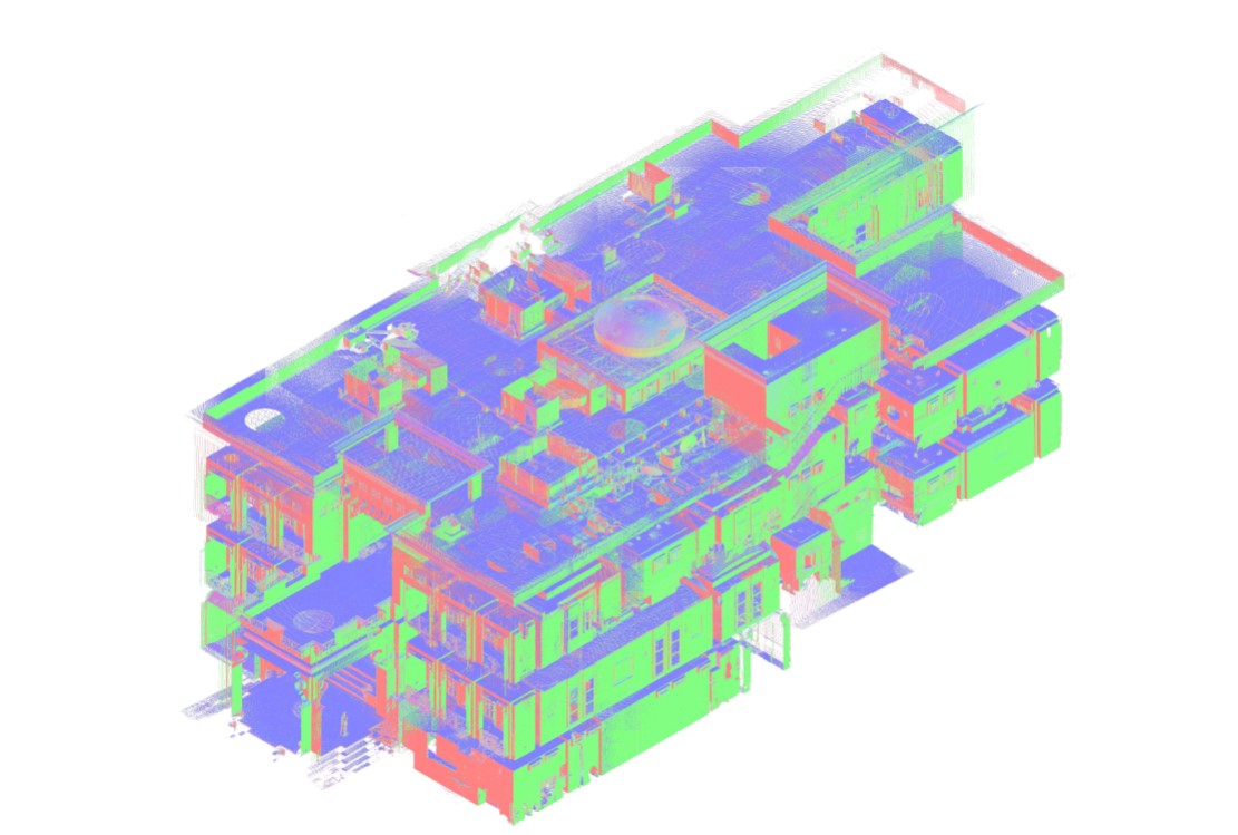
A hydroelectric power station can generate large volumes of 3D measurement data during a laser scanning survey. Turbine halls, generator rooms, technical galleries, penstocks, and mechanical installations contain complex geometry that must be accurately aligned and organized before engineers can use it for design or documentation.
ScanM2 provides Point Cloud Processing Services for Hydroelectric Power Stations, transforming raw laser scanning datasets into registered, cleaned, and structured point clouds. The processed data can be used for dimensional analysis, as-built drawings, BIM modeling, equipment replacement planning, and hydroelectric facility modernization.
Contact Us Now for a Free Consultation!
Why Point Cloud Processing Matters for Hydroelectric Facilities
Laser scanners capture millions of spatial measurements, but raw scans are not automatically ready for engineering use. Individual scan positions may use different local coordinate systems, and the dataset may contain unwanted measurements, redundant points, or areas with limited visibility.
Point cloud processing brings these measurements into a consistent geometric dataset. This allows engineers to examine the existing facility, extract dimensions, and use the captured geometry as a reference for subsequent design work.
For hydroelectric projects, reliable registration is particularly important when survey data covers multiple powerhouse levels, interconnected technical rooms, and equipment areas.
Registering Multiple Laser Scans into One Coordinate System
A hydroelectric power station cannot usually be captured from a single scanner position. Large machinery, structural columns, platforms, and piping systems create occlusions that require measurements from multiple locations.
During registration, individual scans are aligned into a common coordinate system using appropriate registration methods and available reference information.
The result is a combined point cloud in which measurements from different positions can be examined together. Registration quality must be checked to identify alignment problems before the dataset is used for CAD or BIM production.
Processing Point Clouds from Different Hydroelectric Plant Areas
Different parts of a hydroelectric facility present distinct challenges for point cloud processing. The dataset must preserve the geometry relevant to each area while remaining practical to navigate and analyze.
Turbine Halls and Generator Rooms
Large generating equipment, structural columns, floor openings, and overhead installations create complex spatial relationships. Processing must preserve the measurable geometry of these elements so that their positions and clearances can be evaluated.
Penstocks and Pressure Piping
Large cylindrical surfaces, bends, connections, and supporting structures require careful handling of scan alignment and measurement density. Point clouds can provide geometric references for visible pipe surfaces and adjacent infrastructure.
Technical Galleries and Underground Areas
Long corridors, enclosed spaces, and repeated structural features can complicate registration. Suitable scan overlap and reference information are important for maintaining consistent geometry across interconnected areas.
Auxiliary Mechanical Rooms
Dense piping, pumps, valves, and equipment supports create overlapping surfaces and areas of limited visibility. The processed dataset must retain useful details without introducing misleading geometry from noise or registration errors.
Point Cloud Cleaning and Noise Removal
Raw laser scanning data may contain unwanted measurements caused by reflections, moving objects, environmental conditions, or other scanning limitations. These points can interfere with visualization and geometric interpretation.
Cleaning removes identified unwanted data while preserving the measured surfaces needed for engineering work.
Care is required around equipment edges, small components, and closely spaced installations. Excessive filtering can remove legitimate measurements and reduce the usefulness of the dataset.
Managing Large Industrial Point Cloud Datasets
Hydroelectric surveys may cover extensive buildings and multiple technical zones. The resulting datasets can become difficult to store, transfer, and navigate without appropriate organization.
Depending on the project requirements, processing may include:
- Combining individual scan positions into registered datasets
- Organizing point clouds by building, level, or technical area
- Removing identified noise and unwanted measurements
- Preparing optimized copies for specific engineering applications
- Separating relevant project areas for easier navigation
- Exporting data in agreed software-compatible formats
Optimization must be balanced against the need to preserve measurement detail. The appropriate dataset size and point density depend on the intended use.
Point Cloud Alignment for Multi-Level Powerhouse Buildings
Hydroelectric powerhouse buildings frequently contain multiple operating levels, service floors, equipment foundations, and overhead technical installations.
Point clouds collected on different levels must be correctly related within the chosen coordinate system. This is important when engineers need to compare vertical clearances, equipment positions, floor elevations, and structural interfaces.
Where project control points or survey references are available, they can support consistent alignment and coordination with other engineering information.
Point Cloud Quality Control and Registration Verification
A visually convincing point cloud is not necessarily an accurately registered one. Small alignment errors can affect dimensions and the relative positions of equipment and structures.
Quality control involves reviewing registration results, checking relevant overlap areas, examining available reference measurements, and identifying inconsistencies that could affect the intended deliverables.
Project-specific accuracy requirements should be established before processing begins. Any significant data limitations or inaccessible areas should be communicated rather than concealed during editing.
Preparing Point Clouds for As-Built Drawings
Registered point clouds provide a measurable reference for preparing floor plans, sections, elevations, and equipment layouts.
For hydroelectric facilities, this may involve extracting geometric information from turbine halls, equipment foundations, technical rooms, and structural elements.
Our As-Built Drawings Services for Hydroelectric Power Stations use suitable measurement data to produce project-specific technical documentation.
Preparing Point Clouds for BIM Modeling
Developing an existing-condition BIM model requires consistent geometric references. A registered point cloud allows modelers to identify the position and shape of accessible structures, equipment, and engineering systems.
Processing can prepare the dataset for model development by organizing the relevant survey areas and delivering compatible reference files.
For projects requiring the conversion of measured geometry into a structured information model, see our Scan to BIM Services for Hydroelectric Power Stations.
Using Point Clouds to Evaluate Equipment Clearances
Hydroelectric modernization often requires evaluating the space available for replacement equipment, new piping, access platforms, or modified structural elements.
A processed point cloud can support geometric measurements and comparisons with proposed equipment models. Engineers can review the spatial relationship between existing installations and planned modifications.
The reliability of these comparisons depends on registration quality, surface visibility, and the measurement accuracy achieved during the original survey.
Working with Existing Survey Data
Point cloud processing does not always require a new site survey. If a hydroelectric facility already has suitable laser scanning data, it may be possible to register, clean, reorganize, or convert the existing files for a new engineering task.
Before processing, the available files should be reviewed to establish their format, coordinate information, registration status, coverage, and suitability for the intended use.
Missing measurements cannot be reliably reconstructed through point cloud processing alone. Where essential areas were not captured, additional 3D Laser Scanning Services for Hydroelectric Power Stations may be necessary.
Point Cloud Processing for Modernization and Reconstruction
Processed point clouds can serve as a shared geometric reference throughout hydroelectric modernization projects.
Design teams can use the measured dataset to review existing equipment arrangements, prepare reconstruction drawings, develop BIM models, and evaluate the relationship between proposed installations and existing structures.
Where project requirements extend beyond geometric references, our BIM Modeling Services for Hydroelectric Power Stations support the creation of structured digital models for engineering coordination.
Point Cloud Processing Workflow
Our workflow is adapted to the available source data, the complexity of the facility, and the intended engineering deliverables.
- Review source files. Examine scan formats, available reference information, coverage, and processing requirements.
- Register scan positions. Align individual scans into a consistent coordinate system where required.
- Verify alignment. Review registration quality and investigate significant inconsistencies.
- Clean the dataset. Remove identified noise and unwanted measurements while preserving useful geometry.
- Organize project areas. Structure the point cloud according to the agreed buildings, levels, or engineering zones.
- Prepare output files. Export the processed data in the formats required for the next project stage.
- Complete final checks. Review the deliverables for consistency with the agreed processing scope.
Point Cloud Processing Deliverables
Depending on the source data and project requirements, deliverables may include:
- Registered and aligned point cloud datasets
- Cleaned point clouds with identified noise removed
- Organized datasets for individual facility areas
- Point cloud files prepared for CAD and BIM applications
- Agreed exchange formats such as E57, RCP/RCS, or other compatible outputs
- Available registration or processing quality information
Point Clouds for Component Geometry and Reverse Engineering
Some modernization projects require detailed geometric information about individual mechanical components, equipment housings, or custom-built installations.
Processed point clouds can provide measured surface references for these tasks when the relevant features have been captured with sufficient quality and resolution.
For projects requiring reconstruction of component geometry, see our Reverse Engineering Services for Hydroelectric Power Stations.
Reliable Point Cloud Data for Hydroelectric Engineering
Effective point cloud processing transforms a collection of individual measurements into a practical engineering reference. Accurate registration, appropriate filtering, and clear dataset organization help project teams work with the existing geometry of complex hydroelectric facilities.
ScanM2 prepares point cloud datasets for hydroelectric modernization, reconstruction, CAD documentation, and BIM development, with processing requirements defined around the intended engineering use.

