

3D Laser Scanning for Residential buildings
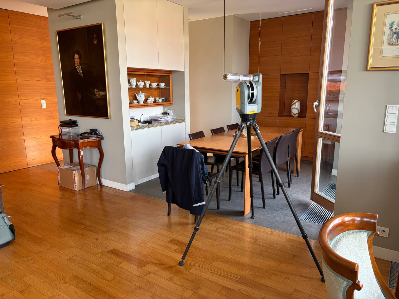
Residential buildings often look straightforward to measure until renovation or redesign begins. Multiple rooms, stairs, changes in floor level, irregular walls, sloped ceilings, built-in elements, façades, and limited access can make conventional measurements difficult to coordinate across an entire property.
ScanM2 provides 3D Laser Scanning Services for Residential Buildings, including houses, apartments, villas, and multi-level residences. Laser scanning captures existing conditions as a coordinated point cloud that can support renovation, interior design, architectural documentation, BIM modeling, and as-built drawing production.
Contact Us Now for a Free Consultation!
Residential Measurement Is More Than Room Dimensions
A residential survey may need to document much more than wall-to-wall distances. Designers can require the relationship between rooms, floor levels, openings, stairs, ceiling geometry, structural elements, and exterior conditions.
3D laser scanning captures visible geometry from multiple positions and combines these measurements into a common spatial reference. Instead of creating a collection of disconnected field dimensions, the survey produces a three-dimensional record of the accessible existing conditions.
Scanning Residential Interiors for Renovation and Redesign
Renovation projects frequently begin with drawings that are incomplete, outdated, or unavailable. Previous remodeling may also mean that the current property no longer corresponds to its original documentation.
Laser scanning provides current measurements before new design work begins. The resulting data can be used to document room geometry, openings, ceiling conditions, stairs, and other features that influence proposed layouts and interior solutions.
Connecting Multiple Floors in One Coordinated Survey
Multi-level homes and apartments introduce another measurement challenge: each floor must relate correctly to the others. Staircases, double-height spaces, floor openings, and changes in elevation create vertical relationships that cannot be fully described by separate room measurements.
By registering scans from different levels into one dataset, laser scanning provides a coordinated spatial reference for the property. This is particularly useful when renovation affects stairs, floor openings, vertical circulation, or architectural elements extending between levels.
Furnished and Compact Residential Spaces
Residential interiors may contain furniture, built-in cabinetry, finishes, and other objects that limit direct visibility. Compact apartments can be especially challenging because many architectural elements are concentrated within a relatively small area.
Scan positions are planned to capture the required visible geometry while reducing blind zones. The survey scope can also be defined around the elements that are actually needed for the subsequent design or documentation task.
Complex Geometry in Houses and Apartments
Not every residential property follows a simple rectangular layout. Renovated houses, custom residences, duplex apartments, and architect-designed villas can include geometry that is difficult to document efficiently with individual manual measurements.
Laser scanning is particularly useful for capturing spatial relationships involving:
- Irregular wall geometry
- Internal staircases
- Sloped and complex ceilings
- Changes in floor elevation
- Double-height spaces
- Non-standard openings
- Built-in architectural elements
- Complex connections between rooms and levels
Interior and Exterior Conditions Can Be Captured Together
Some residential projects require more than an interior survey. Additions, façade renovations, roof modifications, window replacement, and broader architectural redesign can depend on the relationship between interior spaces and the exterior building envelope.
Where required by the project scope, laser scanning can document accessible exterior geometry together with the interior survey, providing a coordinated basis for subsequent architectural work.
What We Capture in a Residential Laser Scan
The required geometry is determined by the project. Depending on the property and intended deliverables, the survey can include:
- Interior and exterior walls
- Floors and ceilings
- Doors, windows, and other openings
- Staircases and vertical connections
- Columns, beams, and visible structural elements
- Built-in architectural features
- Façade geometry where required
- Roof geometry where accessible and included in scope
- Other visible elements required for design or documentation
Project Example: 3D Laser Scanning of a Duplex Apartment in UAE
ScanM2 performed high-precision 3D laser scanning of a residential duplex apartment in Marsa Al Arab, UAE. The property has an area of approximately 90 m² and consists of two levels connected by an internal staircase.
The objective was to create an accurate digital representation of the apartment’s existing condition for interior design, renovation planning, and technical coordination.
The compact interior contained multiple architectural and interior elements, while the two-level configuration required careful scan positioning to maintain the correct vertical relationship between both floors. Particular attention was paid to walls, ceilings, the staircase, doors and windows, and built-in interior elements.
±4 mm Measurement Accuracy
Terrestrial 3D laser scanning was used to capture both apartment levels with a stated measurement accuracy of ±4 mm. Individual scans were processed, registered, and aligned into a single coordinated point cloud.


Deliverables for Design and Renovation
The project produced a complete point cloud of both levels together with 2D documentation. Floor plans, sections, and elevations were delivered in DWG and PDF formats. A 3D model compatible with Revit, ArchiCAD, and other BIM platforms was also available as an optional project output.
View the full 3D Laser Scanning of a Duplex Apartment in UAE case study.
What Happens to the Scan Data After the Site Survey?
Field scanning creates the measured source data, but most residential projects require a usable design or documentation output. Individual scan positions are registered into a coordinated point cloud and prepared for the next project stage.
Our Point Cloud Processing Services for Residential Buildings prepare captured data for subsequent measurement, CAD drafting, modeling, and design workflows.
From Residential Point Cloud to As-Built Drawings
Architects and interior designers often need conventional drawings rather than the raw point cloud. The measured dataset can be used as a geometric reference for floor plans, elevations, sections, and other existing-condition documentation.
For these projects, our As-Built Drawings Services for Residential Buildings convert captured conditions into project-ready 2D documentation.
When the Residential Project Needs a BIM Model
A three-dimensional model can be more useful when renovation requires spatial coordination across multiple floors, complex architectural geometry, structural elements, or several design disciplines.
Our Scan to BIM Services for Residential Buildings use measured point cloud data as the geometric basis for creating models of required existing conditions.
Residential 3D Laser Scanning Workflow
The survey is planned around the property and the required final documentation rather than using the same capture strategy for every residence.
- Define the project requirements. Establish the areas to be captured and the required final deliverables.
- Plan scan positions. Determine how rooms, corridors, stairs, exterior areas, and multiple levels will be connected within the survey.
- Capture existing conditions. Perform terrestrial laser scanning of the required accessible areas.
- Register the scans. Align individual scan positions into a coordinated point cloud.
- Verify the dataset. Review captured geometry and registration before downstream production.
- Prepare required outputs. Process the point cloud for drawings, BIM modeling, measurements, or other agreed deliverables.
Where Residential Laser Scanning Is Used
- Home and apartment renovation
- Interior redesign
- Residential additions and extensions
- As-built documentation
- Scan to BIM projects
- Façade and exterior renovation
- Roof reconstruction and modification
- Complex geometry documentation
- Architectural and interior design coordination
- Existing-condition records
Residential Laser Scanning Deliverables
The final deliverables depend on how the captured residential data will be used. A project can include:
- Registered point cloud
- Processed point cloud data
- 2D floor plans
- Elevations and sections
- Existing-condition BIM model where required
- DWG, PDF, and other agreed project formats
Capture Existing Conditions Before Residential Design Begins
Residential renovation decisions depend on the geometry that exists today. Accurate spatial data gives architects, designers, engineers, and property owners a common reference before layouts are changed, interiors are redesigned, or new construction is connected to an existing home.
ScanM2 combines field capture, point cloud processing, drawing production, and BIM modeling to turn measured residential conditions into usable project information.

