

Point Cloud Processing for Residential buildings
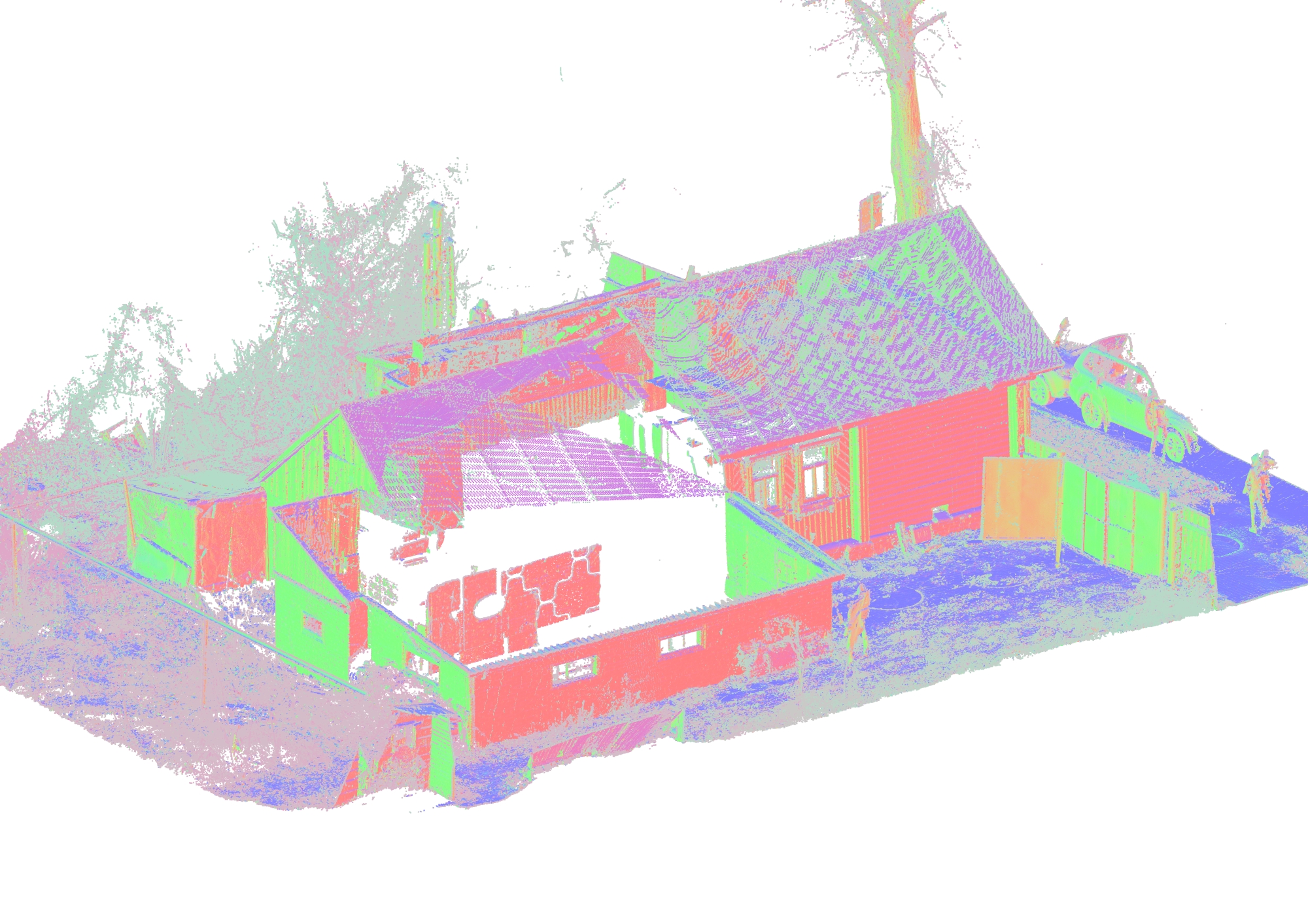
A residential point cloud can contain millions of measured points representing walls, floors, ceilings, façades, roofs, stairs, openings, and surrounding site conditions. But raw scan data alone is not always ready for architects, designers, or BIM specialists to use efficiently.
ScanM2 provides Point Cloud Processing Services for Residential Buildings, transforming laser scanning data from houses, apartments, villas, and other residential properties into coordinated datasets prepared for measurement, CAD drafting, BIM modeling, renovation planning, and existing-condition documentation.
Contact Us Now for a Free Consultation!
A Residential Point Cloud Must Work as One Coordinated Dataset
A residential property is typically captured from multiple scanner positions. Individual scans may cover separate rooms, floors, façades, staircases, roof areas, and exterior zones. These scan positions need to be brought together into a consistent spatial reference before the dataset can support further project work.
Point cloud processing turns separate field captures into a coordinated representation of the measured residence.
Registration Connects Rooms, Floors, and Exterior Geometry
Registration is particularly important in residential buildings because the dataset may need to maintain relationships between enclosed rooms, narrow corridors, staircases, several floor levels, façades, terraces, and exterior areas.
Once the scan positions are registered and aligned, measurements and geometry can be reviewed within a common coordinate system rather than as isolated scan locations.
Cleaning the Point Cloud Without Losing Important Building Geometry
Residential scan data can contain information that is not required for subsequent design or documentation. The processing stage helps prepare a more practical dataset while preserving the geometry needed for the project.
The objective is not simply to remove as many points as possible. Walls, openings, floor and ceiling surfaces, stairs, façades, roofs, and other relevant architectural conditions must remain sufficiently represented for the intended downstream work.
Furnished Residential Interiors Create Dense Scan Data
Unlike an empty construction site, an occupied house or apartment may contain furniture, fixtures, built-in elements, and many overlapping surfaces. These conditions can make residential point clouds visually dense and more difficult to interpret.
Organizing the dataset helps architects, designers, and modeling teams focus on the building geometry relevant to renovation and design rather than navigating an unmanaged collection of scan data.
Multi-Level Homes Need Consistent Vertical Alignment
In a multi-story house or villa, the relationship between levels matters. Staircases, floor openings, balconies, terraces, and roof access connect different parts of the residence and need to remain spatially consistent within the processed dataset.
A coordinated point cloud allows these vertical relationships to be examined together and provides a measured basis for subsequent drawings or models.
Complex Residential Geometry Makes Point Cloud Quality More Important
Residential architecture is not always composed of straight walls and standard openings. Curved façades, radius walls, arches, irregular roofs, exterior stairs, decorative elements, and sloped sites can make geometric interpretation considerably more demanding.
In these situations, the point cloud becomes an important geometric reference. Sections and measured spatial data can be extracted from the dataset to understand shapes that would be difficult to reconstruct reliably from conventional measurements alone.
Organizing Point Clouds for Large Houses and Villas
A residential dataset should remain practical for the people who will use it after scanning. Depending on the size and complexity of the property, data can be organized around floors, building zones, interior and exterior areas, or other logical divisions required by the project workflow.
This can make navigation and downstream production more manageable, particularly when the property includes several levels or extensive exterior geometry.
Preparing Residential Point Clouds for CAD
When the required result is 2D documentation, processed scan data can provide the measured reference for floor plans, ceiling plans, elevations, sections, and other drawings.
Our As-Built Drawings Services for Residential Buildings use existing-condition data to produce documentation for renovation, remodeling, and architectural design.
Preparing Residential Point Clouds for BIM
BIM modeling places different demands on scan data. Modelers need to interpret building surfaces, levels, openings, roof geometry, stairs, façades, and other elements from the measured dataset.
A properly prepared point cloud gives the modeling team a consistent geometric reference for developing the required existing-condition model. For the complete measured-data-to-model workflow, see our Scan to BIM Services for Residential Buildings.
Project Example: Point Cloud Processing for a Complex 300 m² Villa in Dubai
A ScanM2 project involving a 300 m² luxury villa in Dubai demonstrates why reliable point cloud data becomes particularly important when residential architecture contains complex geometry.
The property combines two full floors, an accessible rooftop terrace, rounded façades, radius walls, arched openings, balconies, exterior staircases, castellated parapets, and tower-like architectural elements. The surrounding site also includes local elevation changes.
Project Example Luxury Villa in Dubai


Capturing Geometry That Conventional Measurements Would Struggle to Describe
3D laser scanning produced a dense point cloud dataset representing the villa’s existing conditions. The measured data provided the geometric reference needed to interpret curved surfaces, align arched windows and doors with rounded walls, understand rooftop geometry, and capture elevation changes across the site.
Using Point Cloud Sections to Resolve Complex Geometry
The project required more than simply viewing the scan data in three dimensions. Point cloud information and scan sections were used during modeling to reconstruct complex building forms. Roof geometry, in particular, required a combination of scan sections, geometric constraints, and manual contour adjustments.
From Measured Dataset to LOD250 BIM Model
The processed survey data became the basis for an LOD250 BIM model of the villa and adjacent site. The final documentation included the 3D BIM model, floor plans, roof model, elevations, vertical sections, and digital representation of relevant platforms, ramps, and canopies.
This project shows how a reliable point cloud can preserve complex existing residential geometry and provide the measured foundation for subsequent architectural modeling and documentation.
View the full 3D BIM Modeling of a 300 m² Luxury Villa in Dubai case study.
Residential Point Cloud Processing Workflow
- Review the source scan data. Evaluate the available scans and the requirements of the downstream project.
- Register the scans. Bring individual scan positions into a coordinated spatial dataset.
- Align and verify the dataset. Review the spatial relationship between captured areas and levels.
- Clean the point cloud. Prepare the data while retaining geometry relevant to the project.
- Organize the dataset. Structure scan data so that required areas can be accessed efficiently.
- Prepare for downstream use. Deliver point cloud data suitable for the agreed CAD, BIM, measurement, or documentation workflow.
What Can Be Done with a Processed Residential Point Cloud?
- Existing-condition measurements
- Floor plan production
- Ceiling plans
- Interior and exterior elevations
- Building sections
- BIM modeling
- Renovation and remodeling planning
- Architectural coordination
- Existing-condition documentation
Residential Point Cloud Deliverables
The required outputs depend on the source data and intended downstream workflow. Deliverables can include:
- Registered point cloud
- Cleaned and organized scan dataset
- Point cloud prepared for CAD production
- Point cloud prepared for BIM modeling
- Project-specific point cloud exports in agreed formats
From Field Data to a Working Residential Dataset
The value of residential laser scanning does not end when fieldwork is completed. Scan data needs to become a dataset that architects, designers, engineers, and BIM specialists can actually use.
ScanM2 combines 3D Laser Scanning Services for Residential Buildings with point cloud processing and BIM Modeling Services for Residential Buildings to support the complete workflow from measured conditions to project documentation.

