

Point Cloud Processing for Office buildings
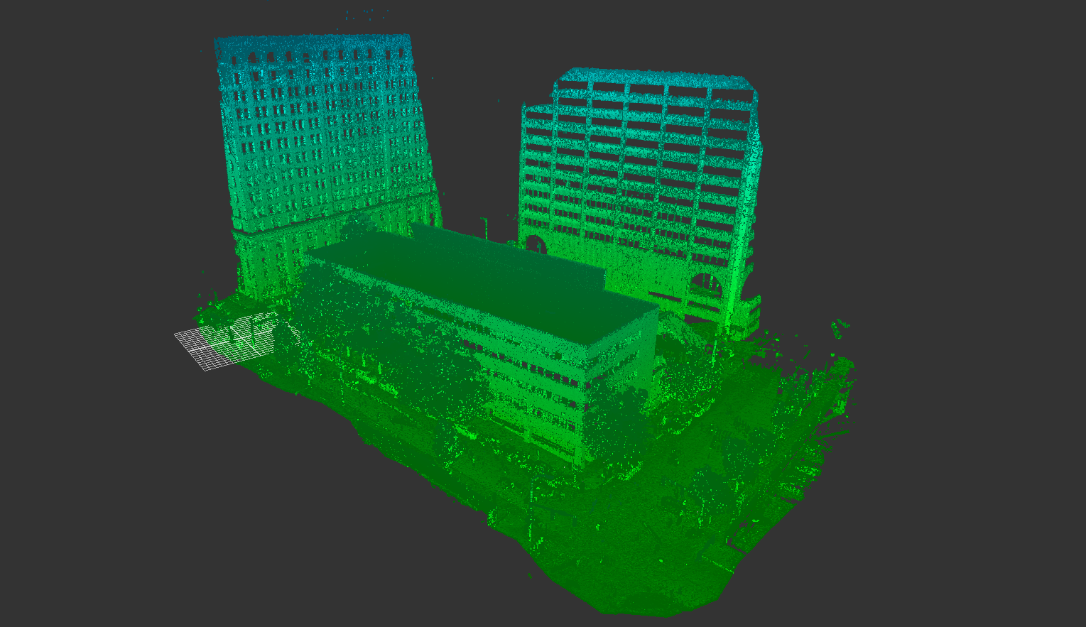
Office building laser scanning can generate millions of measured points across façades, interiors, structural elements, ceilings, roofs, and building systems. Before this data can be efficiently used for CAD drafting, BIM modeling, renovation planning, or design coordination, the individual scans must be registered, cleaned, checked, and organized into a reliable project dataset.
ScanM2 provides Point Cloud Processing Services for Office Buildings for renovation, tenant improvements, workplace reconfiguration, façade projects, as-built documentation, and BIM workflows. We transform raw laser scan data into structured point clouds ready for architects, engineers, contractors, and BIM teams.
Contact Us Now for a Free Consultation!
Point Cloud Processing for Existing Office Buildings
A raw collection of laser scans is not the same as a project-ready point cloud. Individual scan positions must be aligned into a common coordinate system, checked for registration accuracy, cleaned where necessary, and prepared according to the intended downstream use.
For office buildings, this process can involve data captured across multiple floors, tenant spaces, common areas, façades, roofs, technical zones, and other parts of the property. Proper processing brings these separate measurements together into one coordinated representation of existing conditions.
If the project also requires field data capture, our 3D Laser Scanning Services for Office Buildings provide the measured source data for subsequent point cloud processing and documentation.
What Point Cloud Processing Includes
Scan Registration
Individual scans captured from different positions are aligned and combined into a coordinated point cloud. For multi-story office buildings, maintaining consistent relationships between floors, façades, cores, and other building areas is essential for subsequent design and modeling work.
Point Cloud Cleaning
Unwanted or irrelevant data can be removed where appropriate to make the dataset easier to navigate and use. The objective is to preserve the measured building information required for the project while reducing unnecessary visual noise.
Registration Quality Control
The registered dataset is reviewed for alignment and consistency before it is released for drafting or modeling. Problems in registration can propagate into drawings and models, so quality control is an important part of the processing workflow.
Point Cloud Organization
Large office datasets can be organized according to project requirements so that teams can work efficiently with specific floors, areas, façades, or other defined building zones.
Optimization and Export
The processed point cloud can be prepared in formats suitable for the software and workflow used by the project team. This allows the same measured dataset to support CAD, BIM, verification, coordination, and existing-condition analysis.
Processing Point Clouds from Multi-Story Office Buildings
Multi-story office buildings can produce large and complex scan datasets. Multiple floors, repeated room layouts, stairwells, elevator cores, corridors, façades, roof areas, and technical spaces must remain correctly positioned relative to one another.
Organizing the point cloud by floor or building zone can make large datasets easier to manage while preserving the overall coordinate relationship. This is especially useful when different design teams are responsible for separate floors or tenant areas.
Point Clouds for Office Renovation and Tenant Improvements
Renovation projects often begin with incomplete or outdated documentation. A processed point cloud provides a measured digital record of the conditions captured during the survey and allows project teams to examine existing geometry before developing new design solutions.
For tenant improvements, processing can focus on the relevant office floor, suite, or project area rather than forcing designers to work with an unnecessarily large building dataset. Surrounding geometry can be retained where it is needed for coordination with common areas, structural elements, or building systems.
Point Cloud Data for Office Fit-Out
Office fit-out projects require new layouts to work within an existing building. Wall positions, columns, doors, windows, floor levels, ceiling conditions, and visible building services can all influence the proposed design.
A processed point cloud allows architects and designers to inspect and measure captured existing conditions digitally. It can also serve as the source dataset for creating the drawings or BIM models required for the fit-out.
Point Cloud Processing for Office Façades
Office façade surveys can generate dense datasets covering windows, openings, cladding geometry, architectural details, rooflines, and other exterior elements. Processing combines the scan positions into a coordinated representation of the exterior geometry.
The resulting point cloud can support measured elevations, façade renovation, restoration planning, architectural redesign, and 3D modeling without relying exclusively on manual exterior measurements.
Our Office Building Point Cloud Processing Workflow
1. Review the Source Data
We review the available scan data, project scope, required coordinate system, expected outputs, and intended use of the point cloud.
2. Register Individual Scans
Separate scan positions are aligned to create a coordinated representation of the surveyed office building or project area.
3. Clean and Organize the Dataset
Unnecessary data is removed where appropriate, and the point cloud is structured to make navigation and subsequent production more efficient.
4. Perform Quality Control
The registered point cloud is checked for alignment, completeness, and consistency with the required project scope.
5. Optimize for Downstream Use
The dataset is prepared according to whether it will be used for CAD drafting, BIM modeling, renovation design, measurement, coordination, or another defined workflow.
6. Export and Deliver
Processed data is exported in the required point cloud format and prepared for integration into the client’s project environment.
Project Example: Office Building Point Cloud in Wilmington, Delaware
ScanM2 completed a 3D laser scanning survey of a five-story office building at 900 N King Street in Wilmington, Delaware. The project was carried out to support architectural redesign, renovation, and façade restoration.
The survey included the building façades and roof, with approximately 33,690 sq ft of façade area captured at approximately 3 mm precision. Multiple scans documented the existing exterior geometry and architectural conditions.
After field capture, the individual scans were processed into a high-density point cloud. The registered dataset provided the measured foundation for subsequent production of 2D plans and elevations, as-built survey documentation, and a detailed 3D model developed to LOD 200.
Process & Results of 3D scanning office


This workflow allowed the same measured dataset to support several project outputs, demonstrating how a properly processed office building point cloud can become the foundation for both 2D documentation and 3D modeling.
From Point Cloud to As-Built Drawings
A processed point cloud can serve as the measured source for floor plans, elevations, sections, roof plans, and other existing-condition drawings. Designers can work from captured geometry instead of depending entirely on legacy documentation or isolated manual measurements.
When 2D documentation is the required final output, our As-Built Drawings Services for Office Buildings provide a direct workflow from measured scan data to project-ready drawings.
From Point Cloud to BIM
Point clouds can also provide the geometric reference for developing existing-condition BIM models. Walls, floors, openings, façades, structural elements, and required building systems can be modeled against the measured scan data according to the defined project scope.
For projects requiring a structured building model, our Scan to BIM Services for Office Buildings continue the workflow from processed reality-capture data to BIM. We also provide BIM Modeling Services for Office Buildings for renovation, tenant improvements, redevelopment, and design coordination.
Processing Existing Point Cloud Data
Point cloud processing does not always require ScanM2 to perform the original field survey. If laser scan data has already been captured by another survey team, we can review the available dataset and determine whether it is suitable for the required processing, drafting, or modeling workflow.
This can be useful when a client already has raw or partially processed scan data but needs it organized and prepared for use by architects, engineers, CAD specialists, or BIM teams.
Applications of Office Building Point Clouds
- Office renovation and modernization
- Tenant improvement and fit-out
- Workplace reconfiguration
- As-built documentation
- BIM modeling and Scan to BIM
- Façade renovation and restoration
- Architectural redesign
- Existing-condition verification
- Remote measurements
- Design and construction coordination
Point Cloud Deliverables for Office Buildings
Depending on the source data and project requirements, deliverables may include:
- Registered point cloud
- Cleaned and organized point cloud
- Project-specific point cloud subsets
- RCP / RCS files
- E57 point cloud data
- Other agreed point cloud formats
- Datasets prepared for CAD or BIM production
Why Choose ScanM2 for Office Point Cloud Processing
Point cloud processing is not an isolated technical step. The way scan data is registered, organized, and prepared directly affects how efficiently it can be used for drawings, BIM models, renovation planning, and coordination.
ScanM2 combines reality capture, point cloud processing, CAD drafting, and BIM modeling within one workflow. This allows the processed dataset to be prepared with its final purpose in mind, whether the project requires measured drawings, an existing-condition model, façade documentation, or a digital foundation for office renovation.

